
Topo map USGS Amidon Prominence 166 m | Elevation 1,069 m Easiest route Hiking | |
 | ||
Listing U.S. state high point 30th Similar Hawkeye Point, Mount Arvon, Woodall Mountain, Mount Sunflower, Eagle Mountain | ||
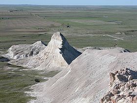
White butte north dakota s highest point
White Butte is the highest natural point in the U.S. state of North Dakota. At an elevation of 3,506 ft (1,069 m), it is a prominent butte in Slope County, in the Badlands of the southwestern part of the state. It is located 3 miles (5 kilometers) east of US 85 and about 6.5 mi (10 km) south of Amidon.
Contents
- White butte north dakota s highest point
- Map of White Butte Chalky Butte ND 58623 USA
- White butte north dakota
- References
Map of White Butte, Chalky Butte, ND 58623, USA
The nearest town is Amidon, about seven miles to the northwest. The summit is located within the boundaries of the Little Missouri National Grassland and is about 35 miles (56 km) south of Theodore Roosevelt National Park. It is on private property, owned by the Dennis family who live nearby. At the trailhead, the family maintains a small mailbox-like receptacle for donations to help maintain the area, and requests a $5 contribution from visitors.
The Killdeer Mountains, 75 miles (121 km) to the north, rise 900 feet (270 m) from their foothills, but are 225 feet (69 m) shorter than White Butte.