
Elevation 448 ft (137 m) | Prominence 32 ft (9.8 m) | |
 | ||
Similar Jerimoth Hill, Charles Mound, Campbell Hill, Britton Hill, Woodall Mountain | ||
Delaware highest point ebright azimuth alt 448 feet
The Ebright Azimuth is the point with the highest benchmark monument elevation in the U.S. state of Delaware. It is marked with a geodetic benchmark monument and has an elevation of 447.85 feet (136.50 m) above sea level. The only state high-point with a lower elevation is Britton Hill in the state of Florida at 345 feet (105 m) above sea level.
Contents
- Delaware highest point ebright azimuth alt 448 feet
- Map of Ebright Azimuth Azimuth DE 19810 USA
- Ebright azimuth delaware s highest point
- Radio tower historyEdit
- References
Map of Ebright Azimuth, Azimuth, DE 19810, USA
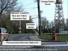
The Ebright Azimuth is located about 6.5 miles (10.5 km) north of downtown Wilmington, Delaware, in far northern New Castle County, within a few feet of the Pennsylvania state line. It is near Concord High School, to the north of Naamans Road, at the middle of the intersection of Ebright Road and Ramblewood Drive. This is an entrance to the Dartmouth Woods development.
Surveying by Delaware Geological Survey personnel indicates that the mobile home park just west of Ebright Road is at least 2 feet (61 cm) higher than the benchmark.
"Ebright Azimuth" is not a person's first and last name. James and Grant Ebright owned the property on which the benchmark was placed.
Since the schematic photograph was taken the blue and yellow monument sign has been moved across the street closer to the geodetic marker. A curb extension has been installed and the area around the sign has been modestly landscaped.
Ebright azimuth delaware s highest point
Radio tower historyEdit
The self-supporting radio tower just south of the benchmark was constructed in 1947 by Western Union as part of an historic C-band microwave radio relay system that linked New York City and Washington, D.C. This site was assigned the name "Brandywine" in recognition of Brandywine Creek located several kilometers to the west and was licensed with the call sign KGB29. Western Union's engineers specified a heavy-duty prefabricated fire tower structure, which allowed the microwave transmitters and receivers to be installed inside the cab. "Dish" antennas, mounted behind the window openings, were aimed towards the adjacent relay stations at Mt. Laurel, New Jersey, 33.8 miles (54.4 km) to the northeast, and Elk Neck near Elkton, Maryland, 30.5 miles (49.1 km) to the southwest.
Like most of their early microwave relay sites, Western Union decommissioned the Brandywine installation near Ebright Azimuth as more-reliable broadband fiber systems were developed. The structure now supports several VHF and UHF land mobile radio antennas.