
Country United States Founded 1734 Elevation 630 ft (192 m) Local time Wednesday 6:26 PM | Incorporated March 21, 1803 Time zone EST (UTC-5) Population 20,508 (2013) | |
 | ||
Weather 14°C, Wind SW at 24 km/h, 21% Humidity Points of interest Cluggy's Amusement Center, The Old Jail, Chambersburg Heritage Center & Gift Shop Colleges and Universities Wilson College, Franklin County Career and Technology Center | ||
Chambersburg is a borough in the South Central region of Pennsylvania, United States. It is 13 miles (21 km) miles north of Maryland and the Mason-Dixon line and 52 miles (84 km) southwest of Harrisburg in the Cumberland Valley, which is part of the Great Appalachian Valley. Chambersburg is the county seat of Franklin County. According to the United States Census Bureau the 2010 population was 20,268. When combined with the surrounding Greene, Hamilton, and Guilford Townships, the population of Greater Chambersburg is 52,273. Chambersburg is at the core of the Chambersburg, PA Micropolitan Statistical Area which includes surrounding Franklin County. The population of the Chambersburg Micropolitan Area in 2010 was 149,618.
Contents
- Map of Chambersburg PA USA
- European settlement
- 17751858
- Underground railroad John Brown
- First two Confederate occupations selective burnings
- Burning of entire town 1864
- General Jubal Early accused of war crimes flees the United States
- Reconstruction of town
- Formation of first school for orphaned children of soldiers killed in the Civil War
- Early memorialization of Civil War
- Contemporary memorialization
- National Register of Historic Places
- Historic images
- Geography
- Demographics
- Economy
- Culture
- Government
- Wilson College
- Public schools
- Scotland School for Veterans Children
- Private schools
- Library
- Newspapers
- Television and radio
- Sister city
- Notable people
- References
Map of Chambersburg, PA, USA
Chambersburg's settlement began in 1730 when water mills were built at the confluence of Conococheague Creek and Falling Spring Creek that now run through the center of the town. Its history includes episodes relating to the French and Indian War, the Whiskey Rebellion, John Brown's raid on Harpers Ferry, and the American Civil War. The borough was the only major northern community burned down by Confederate forces during the war.
Chambersburg is located along the Lincoln Highway, U.S. 30, between McConnellsburg and Gettysburg, Pennsylvania and along U.S. 11, the Molly Pitcher Highway, between Shippensburg, Pennsylvania, and Hagerstown, Maryland. Interstate 81 skirts the borough to its east. The town also lies approximately midpoint on US Route 30 between Pittsburgh and Philadelphia with the local geography reflecting both flatter areas like Philadelphia and mountainous areas like Pittsburgh.
European settlement
Native Americans living or hunting in the area during the 18th century included the Iroquois, Lenape and Shawnee. "Falling Spring" was first settled by Benjamin Chambers, a Scots-Irish immigrant, in 1730, who started a grist mill and saw mill by a then-26-foot (7.9 m) high waterfall where Falling Spring Creek joined Conococheague Creek. The creek provided power to the mills, and the settlement was known as "Falling Spring."
On March 30, 1734, Chambers was issued a "Blunston license" for 400 acres (160 ha), from a representative of the Penn family, but European settlement in the area was of questionable legality until the treaty ending the French and Indian War, because not all Indian tribes with land claims had signed treaties. The Penn family encouraged settlement in the area in order to strengthen its case in a border dispute with the Maryland Colony, which had resulted in hostilities known as Cresap's War. This dispute was not settled until 1767 and the surveying of the border known as the Mason-Dixon line. Chambers traveled to England to testify in support of Penn's claims. To maintain peace with the Indians, European settlers were sometimes removed from the nearby area. In May 1750, Benjamin Chambers participated in removing settlers from nearby Burnt Cabins, which took its name from the incident.
The area was officially part of Chester County, then Lancaster, and then Cumberland until it became part of the newly established Franklin County in 1784.
The Great Wagon Road connecting Philadelphia with the Shenandoah Valley passed nearby. In 1744, it was completed through Harris's Ferry, Carlisle, Shippensburg, and Chambersburg to the Potomac River.
In 1748 a local militia was formed for protection against Indians, with Benjamin Chambers being named colonel.
Chambersburg was on the frontier during the French and Indian War. The area's population dropped from about 3,000 in 1755 at the start of the war to about 300, with most settlers not returning until after 1764 when the peace treaty was signed. Benjamin Chambers built a private stone fort during the war, which was equipped with two 4 pounder cannons and fighting occurred nearby. Because Chambers's fort was otherwise lightly defended, the authorities attempted to remove the cannons to prevent them from being captured by Indians and used against other forts. The attempted removal was unsuccessful, and one of the cannons was used to celebrate Independence Day in 1840. The Forbes Road and other trails going to Fort Pitt passed nearby as well. The Forbes Road developed into part of the main road connecting Pittsburg and Philadelphia, and much later into US 30, and Chambersburg developed as a transportation hub at the crossroads of Forbes Road and the Great Wagon Road.
Fighting continued in the area after the war, most notably the Enoch Brown school massacre during Pontiac's War and the Black Boys rebellion against British troops at Fort Loudon.
The first settlers were Scots-Irish Presbyterians and German Protestants came soon afterward. Quakers and English Protestants, who made up a large proportion of early Pennsylvania settlers, did not often move as far west as Chambersburg. Blacks lived in Chambersburg almost from the start of settlement. Benjamin Chambers owned a black female slave sometime before the French and Indian War and twenty slaves were recorded as taxable property in 1786.
The earliest church was established by Scots-Irish Presbyterians in 1734. Chambers gave land to the congregation in 1768, requiring only a single rose as annual rent. Later land was given to the First Lutheran Church (1780) and Zion Reformed Church (organized in 1780) under the same agreement, and these churches came to be known as the "Rose Rent Churches." A Catholic community organized in 1785. The Jewish cemetery dates back to 1840. The Mt. Moriah First African Baptist Church dates to 1887.
The town was first laid out in 1764, and lots were advertised for sale on July 19 in Benjamin Franklin's Pennsylvania Gazette
Notice is hereby given to the Public, that there is a town is laid out on Conegogig Creek, on both sides of the Great Falling Spring, where is falls into said creek, by Benjamin Chambers, of Cumberland County. Lots may be had on reasonable terms and Firm Deeds granted for them by said Chambers: the day appointed for drawing of said lots is the 28th day of June inst.. which is a Thursday. The situation of this town is very good for water and stone, both free and marble, and sand all handy to the spot, and a well timbered part of the country adjoining it; within said town is a good Gistmill, Sawmill, and Grindstones going by water. The articles of the Town shall be read on the day appointed for the drawing of the Lots, and the terms of the sale published by me
1775–1858
In June 1775, soon after the Battle of Lexington, local troops were raised to fight the British in the American Revolution under the command of Benjamin Chambers's eldest son Captain James Chambers, as part of the 1st Pennsylvania Regiment. These troops were among the first non-New Englanders to join the siege of Boston, arriving on August 7, 1775. James Chambers fought for seven years during the revolution, reaching the rank of Colonel of Continental troops on September 26, 1776. His two brothers, William and Benjamin, Jr., each served for much of the war and reached the rank of Captain. James Chambers commanded local troops at the Battle of Long Island, and at White Plains, Trenton, Princeton, Brandywine, Germantown and Monmouth. He was part of the rear guard covering the retreat from Brooklyn, and was wounded at the Battle of Brandywine while facing Hessian troops under General Knuphausen at Chadds Ford.
During the Whiskey Rebellion, local citizens raised a liberty pole in support of the rebels, and to protest conscription of soldiers to put down the rebellion. Nevertheless, these citizens were censured in a town meeting and removed the pole the next day. President George Washington, while leading United States troops against the rebels, came through town on the way from Carlisle to Bedford, staying overnight on October 12, 1794. According to tradition, Washington lodged with Dr. Robert Johnson, a surgeon in the Pennsylvania line during the Revolution. This march was one of only two times that a sitting president personally commanded the military in the field. (The other was after President James Madison fled the British occupation of Washington, D.C. during the War of 1812.) After sending the troops toward Pittsburgh from Bedford under General Henry "Light Horse Harry" Lee, Washington returned through Chambersburg sometime between October 21–26. James Chambers was appointed a Brigadier General of Militia during the Whiskey Rebellion.
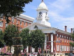
Chambersburg was incorporated on March 21, 1803, and declared the County Seat when the State Assembly established a formal government. The first courthouse was John Jack's tavern on the Diamond (town square) in 1784, with a permanent courthouse built in 1793, and the first county jail built 1795. The "Old Jail" was built in 1818, survived the fire of 1864 and is the oldest jail building in Pennsylvania. It was originally used as the sheriff's residence and had the longest continuous use of any jail in the state, operating until 1971. Today the Old Jail is a museum and home to the Franklin County – Kittochtinny Historical Society. The county's gallows still stand in the jail's courtyard.
Much of the town's growth was due to its position as a transportation center, first as the starting point on the Forbes Road to Pittsburgh. The U.S. Congress placed Chambersburg on the Philadelphia-Pittsburgh postal road in 1803. The road was rebuilt as the Chambersburg-Bedford Turnpike in 1811. The Cumberland Valley Railroad was built in 1837 and was the area's center of economic activity for nearly 100 years. Until the completion of the Pennsylvania Railroad's main line in 1857, the fastest route from Pittsburgh to Philadelphia was by stagecoach from Pittsburgh to Chambersburg, and then by train to Philadelphia.
Underground railroad / John Brown
By 1859, Chambersburg was a stop on the Underground Railroad. John Brown stayed in an upstairs room at Mary Ritner's boarding house between June and October, 1859 while preparing for his raid on Harpers Ferry. Several of his fellow raiders stayed in the house as well, and four of them escaped capture and briefly visited the house after the raid. The house still stands at 225 East King Street. While in Chambersburg Brown posed as Dr. Isaac Smith, an iron mine developer, and bought and stored weapons under the guise of mining equipment.
Brown (using the name John Smith) and John Henry Kagi met with Frederick Douglass and Shields Green at an abandoned quarry outside of town to discuss the raid on August 19. According to Douglass's account, Brown described the planned raid in detail and Douglass advised him against it. Douglass also provided $10 from a supporter, and had helped Green – a future raider – locate Brown.
First two Confederate occupations, selective burnings
During the American Civil War on October 10, 1862, Confederate Maj. Gen. J.E.B. Stuart, with 1,800 cavalrymen, raided Chambersburg, destroying $250,000 of railroad property and taking 500 guns, hundreds of horses, and at least "eight young colored men and boys." They failed, however, to accomplish one of the main targets of the raid: to burn the railroad bridge across the Conococheague Creek at Scotland, five miles (8 km) north of town.
During the early days of the 1863 Gettysburg Campaign, a Virginia cavalry brigade under Brig. Gen. Albert G. Jenkins occupied the town and burned several warehouses and Cumberland Valley Railroad structures and the bridge at Scotland. From June 24–28, 1863, much of the Army of Northern Virginia passed through Chambersburg en route to Carlisle and Gettysburg, and Robert E. Lee established his headquarters at a nearby farm.
Burning of entire town 1864
The following year, Chambersburg was invaded for a third time, as cavalry, dispatched from the Shenandoah Valley by Jubal Early, arrived. On July 30, 1864, a large portion of the town was burned down by Brig. Gen. John McCausland for failing to provide a ransom of $500,000 in U.S. currency, or $100,000 in gold. Among the few buildings left standing was the Masonic Temple, which had been guarded under orders by a Confederate mason. Norland, the home of Republican politician and editor Alexander McClure, was burned even though it was well north of the main fire.
One black Chambersburg resident was killed when Confederates refused to allow him to leave his burning house. Another man was asked by the Confederates if he had ever educated "niggers"; after replying that he had, the Confederates burned his house as well. Subsequently, "Remember Chambersburg" soon became a Union battle cry.
General Jubal Early accused of war crimes: flees the United States
Lieutenant General Jubal Early was accused of war crimes for ordering the burning of Chambersburg. When the Army of Northern Virginia surrendered on April 9, 1865, Early escaped to Texas by horseback, where he hoped to find a Confederate force still holding out. He proceeded to Mexico, and from there, sailed to Cuba and Canada. Living in Toronto, he wrote his memoir, A Memoir of the Last Year of the War for Independence, in the Confederate States of America, which focused on his Valley Campaign. The book was published in 1867.
Reconstruction of town
The town was rebuilt with a combination of state and private funding. Many new buildings were erected quickly and were not initially built to the original standards.
It took more than 30 years to fully restore the town's housing stock to pre-Civil War standards.
Formation of first school for orphaned children of soldiers killed in the Civil War
Due to an incident where two children of dead Union soldiers came begging for food to the doors of Chambersburg residents, the first school in Pennsylvania was created to serve children of Veterans orphaned due to war. The Governor of the state eventually established 69 additional such schools across the state. The original school in Chambersburg was renamed "The Scotland School for Veterans Children" in the 1890s.
The school remained open until 2010 and graduated more than 10,000 children during its lifetime.
Early memorialization of Civil War
Memorial Fountain, built in the center of the diamond to honor the Civil War soldiers, was dedicated on July 17, 1878 with fifteen thousand people in attendance.
A statue of a Union soldier stands next to the fountain, facing south to guard against the return of southern raiders.
Contemporary memorialization
To this day, the Civil War burning of Chambersburg remains a part of the town's historic identity and yearly memorial events are held.
Chambersburg has also recently been the subject of study on how people have historically perceived and responded to war tragedies.
National Register of Historic Places
The following places in Chambersburg are on the National Register of Historic Places:
Historic images
Colorized photographs taken from a series of 22 postcard views mailed in 1921.
Geography
According to the United States Census Bureau, Chambersburg has a total area of 6.8 square miles (17.6 km2), all land. The elevation is 617 feet (188 m) above sea level. Chambersburg is located in the Cumberland Valley next to the Appalachian Mountains. It also sits right outside of Caledonia State Park, a 1,125-acre (455 ha) park with fishing and hunting areas and hiking trails, including a section of the Appalachian Trail. Also outside of Chambersburg is Michaux State Forest, a 85,000-acre (34,000 ha) forest. Both of these places provide recreation for residents.
Conococheague Creek, a noted trout stream, runs through the center of town. It is a tributary of the Potomac River. The northernmost reach of the Potomac watershed is a few miles north of town.
Chambersburg has a cold climate, according to the United States Department of Energy. The area receives anywhere from 38 to 42 inches (970 to 1,070 mm) of precipitation per year. And Chambersburg falls within the warmest part of the Humid Continental Climate with some characteristics in the summer of a Humid Subtropical Climate, but bears much more characteristics of the former. The average January low is 20 °F (−7 °C) and the average high is 37 °F (3 °C). The average July high is 85 °F (29 °C) and the average low is 62 °F (17 °C).
Demographics
As of the census of 2000, there were 17,862 people, 7,722 households, and 4,386 families residing in the borough. The population density was 2,601.3 people per square mile (1,003.9/km2). There were 8,305 housing units at an average density of 1,209.5 per square mile (466.8/km2). The racial makeup of the borough was 86.43% White, 7.56% African American, 0.18% Native American, 0.87% Asian, 0.05% Pacific Islander, 3.08% from other races, and 1.83% from two or more races. Hispanic or Latino of any race were 6.38% of the population.
There were 7,722 households, out of which 24.1% had children under the age of 18 living with them, 41.2% were married couples living together, 11.7% had a female householder with no husband present, and 43.2% were non-families. 37.5% of all households were made up of individuals, and 16.8% had someone living alone who was 65 years of age or older. The average household size was 2.16 and the average family size was 2.83.
In the borough the population was spread out, with 20.8% under the age of 18, 9.1% from 18 to 24, 26.8% from 25 to 44, 20.6% from 45 to 64, and 22.7% who were 65 years of age or older. The median age was 40 years. For every 100 females there were 81.7 males. For every 100 females age 18 and over, there were 77.1 males.
The median income for a household in the borough was $32,336, and the median income for a family was $40,352. Males had a median income of $31,803 versus $21,548 for females. The per capita income for the borough was $19,278. About 9.8% of families and 12.9% of the population were below the poverty line, including 18.3% of those under age 18 and 9.1% of those age 65 or over.
The population stood at 7,863 in 1890; 8,864 in 1900; 11,800 in 1910; 13,171 in 1920; and 14,852 in 1940. It was estimated to be around 18,000 people in January 2008.
Economy
The surrounding area has a large farming population, including many Amish and Mennonite families. Franklin County's largest crop is corn (maize) with 579 farms that cover 29,916 acres (12,107 ha) of land. Franklin also has 344 wheat farms and 299 barley farms which combined cover 14,063 acres (5,691 ha). Manufacturing in Chambersburg includes machinery production, metal fabrication, and food processing according to the 1997 Economic Census of Franklin County. The largest sectors by payroll were manufacturing companies such as T B Wood's Inc., Manitowoc cranes, retail trade, and health care and social assistance. Despite suburban growth, much of the economy of the area is still largely based on agriculture.
Retail stores such as Wal-Mart and Lowe's serve the population with jobs and basic needs. The Chambersburg Mall with four anchor stores and about fifty smaller stores is located in the unincorporated village of Scotland, about four miles (6 km) north of town on Interstate 81. Chambersburg's retail sector has grown quickly since 2006 with the opening of Target, Petsmart, Michaels, and Kohls near the newly built Exit 17 of Interstate 81. Several restaurants new to the region have also opened, including Sonic, Starbucks, T.G.I. Fridays, Red Robin, Fuddruckers, Ruby Tuesday, Panera Bread, Chipotle, Texas Roadhouse, Olive Garden, and Longhorn Steakhouse.
The city's location on Interstate 81 within 100 miles (160 km) of both Washington, D.C. and Baltimore, Maryland encourages trucking and distribution businesses. The Letterkenny Army Depot five miles (8 km) north of town is a major employer. Camp David also employs Chambersburg residents. In 2004 Chambersburg had a per capita personal income (PCPI) of $28,208, below the national average of $33,050.
Culture
Chambersburg is part of small town America. Recreation includes hunting, sports events such as baseball games at Henninger Field, and high school football games. The town also hosts a professional football team, the Chambersburg Cardinals, that plays in the Gridiron Developmental Football League. People in the area speak in Pittsburgh English or with a Central Pennsylvania accent, over-pronouncing "O's" and "I's". Caledonia State Park provides an area for outdoor activities, with the park especially busy on July 4.
The Capitol Theatre was opened as a movie palace on Main Street in 1927. In 2003, it reopened as the Capitol Theatre Center and is home to the Capitol Theatre Main Stage and Auditorium, Chambersburg Council for the Arts, Caledonia Theatre Company, Chambersburg Ballet Theatre School, and Chambersburg Community Theatre. In 2009, Chambersburg ranked among Newsmax magazine's list of the "Top 25 Most Uniquely American Cities and Towns," a piece written by current CBS News travel editor Peter Greenberg. In determining his ranking, Greenberg cited the Capitol Theatre.
Wilson College is home to the Cumberland Valley School of Music, a local school offering private instruction on various musical instruments. It offers a wide range of lessons, classes, workshops, and summer camps, as well as presenting numerous recitals and concerts in Thomson Hall. CVSM sponsors a children's chorus (the Cumberbunds), a community band, a community orchestra, a concert jazz band, and the New Horizons Band, for adults age 50 or older.
Journalist David Brooks in 2001 used Chambersburg and Franklin County to typify Republican “Red America.” According to Brooks, there is little obvious income inequality and people don’t define their place in society by their income level. They value the work ethic and are anti-union, anti-welfare, pro-free market, and religious social conservatives.
Government
The municipal government operates under the Pennsylvania Borough Code, with the Town Council holding both legislative and executive authority. The ten councilmen are elected from five wards; two from each ward with staggered four-year terms. The Mayor administers the Police Department and can cast tie-breaking votes on the Council. Other departments are administered by the Borough Manager.
Darren Brown became Mayor on January 6, 2014.
As of January 2016, the town councilmen are:
Samantha J. Bietsch, 2nd Ward (R)
Sharon A. Bigler, 4th Ward (D)
Jeremy D. Cate, 4th Ward (D)
Allen B. Coffman, 1st Ward (R)(Council President)
Louisa C. Cowles, 3rd Ward (D)
Herbert R. Dolaway, 5th Ward (D)
Alice C. Elia, 1st Ward (D)
Kathy J. Leedy. 3re Ward (D)
John "Sean" A. Scott III, 2nd Ward (D)
Heath E. Talhelm, 5th Ward (D)(Council Vice President)
Chambersburg is part of the 9th Congressional District of Pennsylvania and represented by Bill Shuster (R) in the House of Representatives, and by Pat Toomey (R), and Bob Casey, Jr.(D) in the Senate.
Wilson College
Wilson College is a private, Presbyterian-related, liberal arts women's college founded in 1869 and named for its first major donor, Sarah Wilson of Chambersburg. The college has 800 students and is known for its Women With Children, Veterinary Medical Technician, and Equestrian programs. Once an all women's school, it currently is co-education. In 2009, the school opened the first "green" campus building in Chambersburg, PA. The building is part of the science and technology department and features a full-length waterfall in the lobby. The waterfall begins on the third floor and ends in the basement of the building.
Public schools
Chambersburg Area Senior High School (CASHS) is a public school with around 2,400 students in grades 9–12, drawn from the borough of Chambersburg and the surrounding townships of Hamilton, Greene, Lurgan, Letterkenny and Guilford. CASHS is accredited by the Middle States Association and has occupied its current facilities since 1955. Principal Dr. Barry Purvis was recognized as the 2006 High School Principal of the Year by the Pennsylvania Association of Elementary and Secondary School Principals.
Until August 2011, J. Frank Faust Junior High School was the only public junior high school for eighth and ninth grade students of the Chambersburg Area School District. It served about 1400 students. J. Frank Faust is now a middle school for Chambersburg area students in the north. CAMS NORTH. It has 6th through 8th grade.
Chambersburg Area Middle School SOUTH was the only middle school, but as of August 2011, it became CAMS SOUTH, 6th through 8th grade. During the 2001–02 school year, CAMS was recognized with the Blue Ribbon School Award of Excellence by the United States Department of Education, the highest award an American school can receive.
The Franklin County Career and Technology Center is also located in Chambersburg. FCCTC is a school designated for students and adults to learn vocational trades while still learning core subjects in school. The school offers training in about 20–30 different concentrations. There are currently six different school districts with students attending FCCTC: Chambersburg, Fannett-Metal, Greencastle-Antrim, Shippensburg, Tuscarora, and Waynesboro.
The Chambersburg school district includes seventeen elementary schools. Many school are being upgraded, rebuilt, or closed because of out-of-date buildings and lack of space. As of July 2008, the current School Board President is Stanley Helman. Other members include Anne Boryan, Renee Sharpe, Norman Blowers, Lori Leedy, Fred Rice, Dave Schiamanna, and Joe Tosten. One seat is currently being filled after the resignation of the previous board president, Dr. Thomas Orndorff.
Scotland School for Veterans' Children
The Scotland School for Veterans' Children (SSVC) was a state owned school that offered tuition-free residential education programs for children of Pennsylvania residents who are veterans or are currently serving in the U.S. armed forces. Scotland School had an original founding date of 1863. It was founded as a result of two orphaned children going door to door begging for food. They knocked on the door of then governor, Andrew Gregg Curtin. Governor Curtin and his wife realized there was a forgotten group of people resulting from the American Civil War, the orphaned children of soldiers. Governor Curtin set up 70 schools across the state and they became known as the 'Soldier's Orphan Schools'. As students graduated, the student bodies of the schools began to decline and in 1895 all of the schools closed saved one, the one located in Scotland. The name was changed to Scotland School for Veteran's Children. The purpose was then changed to provide an education to any child of any veteran, whether that veteran was living or deceased. Because of this new purpose and subsequent name change, the founding date of the school was changed to 1895. It was located about four miles (6 km) north of Chambersburg in the unincorporated village of Scotland and had about 300 students in grades 3–12. The school was established in 1895 as the Pennsylvania Soldiers Orphans Industrial School. Over 10,000 students have been educated at the school. The 186-acre (75 ha) campus contains about 70 buildings including residential cottages. In 2009, Governor Ed Rendell removed funding for the school in the year's state budget, thereby forcing the school to close.
Private schools
Private schools include Corpus Christi, a Catholic school with 310 students and over 20 teachers and Cumberland Valley Christian School, a private Christian kindergarten through twelfth grade academy located in Chambersburg. Cumberland Valley Christian School is affiliated with the Open Door Church and has approximately four hundred students. Other private schools include the Montessori Academy of Chambersburg (22 months-12th grade, non-sectarian) and Shalom Christian Academy (K-12, Mennonite affiliation), and several elementary schools with Mennonite, Baptist, Brethren, Christian Science, and other religious orientations.
Library
Coyle Free Library has roots going back to 1891, when a library of 166 books was organized by the local Afternoon Club. A member of the club, Blanche Coyle, left a bequest of $30,435 in 1915 to construct a library building. The building was completed in 1924, located at the corner of Second and Queen Streets. Later the library was made part of the Franklin County Library and began to receive funds from the County and State, though the Afternoon Club still donated funds though at least 1979. The building it currently occupies is a former post office.
Newspapers
The Chambersburg Public Opinion is the only daily newspaper published in town, and has weekday circulation about 17,000. It was founded in 1869 and is now owned by Gannett.
Television and radio
Television reception can be poor because of the surrounding mountains. WJAL, a family oriented station broadcasts from Chambersburg, and Harrisburg PBS station WITF-TV rebroadcasts via low-powered translator W38AN. Franklin County is included in Harrisburg DMA. All Harrisburg TV stations are available off air and on cable. WHTM is the first network affiliated television station to establish a bureau in Chambersburg. WHAG-TV, WWPB, and WWPX, broadcast from nearby Hagerstown, Maryland.
Chambersburg shares a radio market, the 165th largest in the United States, with Waynesboro, Pennsylvania, and Hagerstown, Maryland.