
Joined 1481 | ISO 3166 code CH-FR | |
 | ||
Subdivisions 168 municipalities, 7 districts Lowest point 429 m (1,407 ft): shore Lake Neuchâtel | ||
The Canton of Fribourg is a canton of Switzerland. It is located in the west of the country. The capital of the canton is Fribourg. The name Fribourg is French, whereas Freiburg is the German name for both the canton and the town.
Contents
- Map of Canton of Fribourg Switzerland
- History
- Geography
- Districts
- Municipalities
- Demographics
- Economics
- Transport
- Federal election results
- References
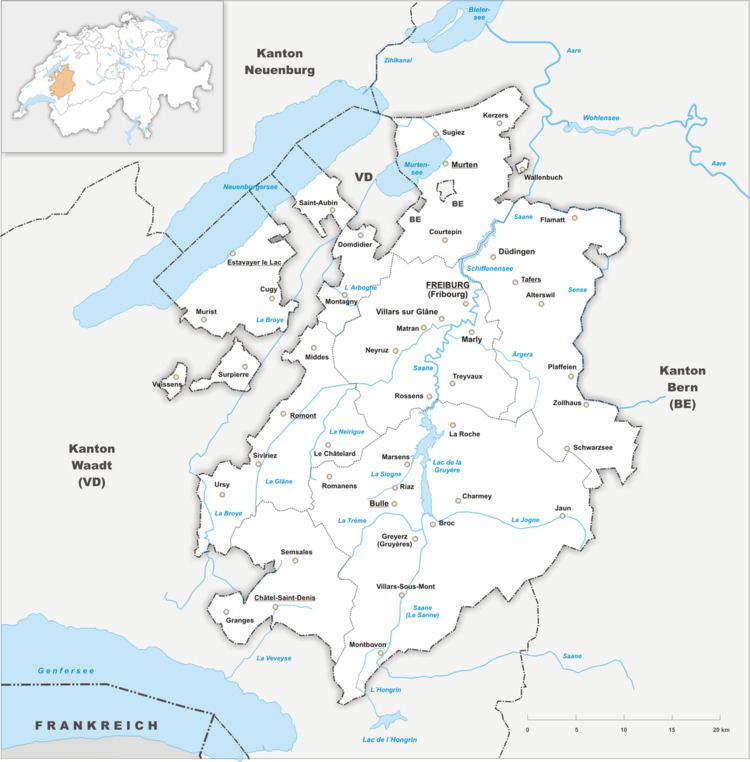
Map of Canton of Fribourg, Switzerland
History
On the shores of Lake Neuchâtel and Lake Morat significant traces of prehistoric settlements have been unearthed.
The canton of Fribourg joined the Swiss Confederation in 1481. The area is made up of lands acquired by the capital Fribourg. The present extent was reached in 1803 when Murten (Morat) was acquired. The canton of Fribourg joined the separatist league of Catholic cantons in 1846 (Sonderbund). The following year, its troops surrendered to the federal army.
Geography
The canton of Fribourg lies in the west of Switzerland. It is bounded to the west by the Lake of Neuchâtel. To the west and the south of the canton lies the canton of Vaud. To the east the canton of Fribourg is bounded by the canton of Bern. There are two enclaves within Vaud and one within the canton of Bern, as well as a large exclave on the lake. The area of the canton of Fribourg is 1,669 square kilometers (644.4 sq mi), including the small enclaves.
The canton lies on the elevated Swiss Plateau. In the west the lands are flat, but towards the south east of the canton, the lands rise to a hilly region. This region is commonly called pre-Alps but is part of the Bernese Alps. The highest elevation in the canton is the Vanil Noir with 2,389 m (7,838 ft).
The river Saane (Sarine) flows from the south to the north of the canton. Together with its tributaries it drains most of the lands in the canton. The river Saane later joins the river Aare. The river Broye drains the west of the canton and flows northeast into Lake Morat (Murtensee). The southwest part of the canton is drained by the river Veveyse which flows south into Lake Geneva (French: Le Léman).
Districts
The Canton is divided into 7 districts:
Municipalities
There are 165 municipalities in the canton of Fribourg as of January 2012. The number is decreasing as the canton subsidizes mergers between municipalities.
Demographics
In contrast to the mainly Protestant cantons of Vaud to its west and Bern to its east, the canton of Fribourg is a predominantly Roman Catholic enclave (as of 2000, 70%) with a Protestant minority (15%). This explains the canton's existence, even though it straddles the French-German linguistic border, for in the past, denominational considerations were more important than linguistic when drawing Switzerland's cantons.
The main centres of population are the capital Fribourg (34,300 inhabitants) and Bulle (18,200 inhabitants).
Two-thirds of the population speak French, and one-third speaks Alemannic dialects of German. The French-speaking areas are in the west of the canton, whereas the Alemannic-speaking areas are in the east. There are a number of bilingual towns, a fact that has attracted some businesses, such as telesales. The population of the canton (as of 31 December 2015) is 307,461. As of 2007, the population included 43,838 foreigners, or about 16.65% of the total population.
Economics
Agriculture is important in the canton of Fribourg. The main agricultural activities are cattle breeding and dairy farming. Cheese-making is established, in particular in the district of La Gruyère, home of the cheese with the same name. The chocolate making industry is also well established in Broc, where even an international research centre has been lately inaugurated (see: [1]. Other agricultural produces include tobacco, fruit and cereals. Agriculture is predominant in the north of the canton where the most fertile lands lie.
There is light industry concentrated around the capital Fribourg. Other centres of light industry are Bulle, Villars-sur-Glâne, Düdingen (Guin), Murten (Morat) and Estavayer-le-Lac. These five centers have also a large number of established small and medium-sized businesses, many of which are in the service sector. Forests are important in the La Gruyère (Greyerz) district.
The district of La Sarine is home to electric power plants used for home use as well as export. The mountain areas attract tourists all year round. The lake regions are frequented by tourists - mainly families - in summer and autumn.
Transport
The canton of Fribourg is well connected to other areas of Switzerland with motorways A1, A12 and fast rail links. The main railway between Geneva and Lausanne in the south west to Bern and Zürich connects Fribourg with other centres of the country.