
Length 171.8 km | ||
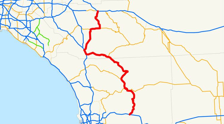 | ||
State Route 79 (SR 79) is a state highway in the U.S. state of California. The route begins at Interstate 8 (I-8) in San Diego County, continuing north through the town of Cuyamaca into Julian. After passing through Warner Springs, the route crosses into Riverside County, providing access to the cities of Temecula and Murrieta. SR 79 ends at I-10 in Beaumont.
Contents
Map of CA-79, California, USA
Route description
SR 79 begins at exit 40 of I-8, about 40 miles (64 km) from its western terminus and approximately 35 miles (56 km) east of San Diego. The road runs along Old Highway 80 in the town of Descanso, until splitting to the north at a T intersection. The route then traverses Cuyamaca and Cuyamaca Rancho State Park on its way north. This portion of the route is very serpentine, with hairpin turns, as it follows the contours of the land by moving laterally, rather than up-and-down or via cuts.
It then overlaps SR 78 between Santa Ysabel and Julian, a distance of about eight miles (13 km). At Julian, both routes join at a T intersection just south of town, thus requiring a turn to stay on SR 79, and turn at an intersection in the northern portion of downtown. At Santa Ysabel, SR 79 comes to a T intersection with SR 78 running east–west. SR 79 continues northwest, meeting the eastern terminus of SR 76 near Lake Henshaw at the settlement of Morettis and passing through Warner Springs before crossing into Riverside County. SR 79 then meets the southern terminus of SR 371 before going through Aguanga.
It overlaps I-15 for a few miles through Temecula. The ramps connecting SR 79 to I-15 are the first and third ramps (in either direction) of the three located between the I-15/I-215 junction and the Riverside/San Diego county line (these are also the only three exits on I-15 which directly serve Temecula). In both cases, to enter SR 79 from I-15, one must head slightly east (although SR 79 is signed as a north–south highway). The southern exit from I-15 is known as Temecula Parkway, which was the name given to the southern portion of the route in September 2007. SR 79 exits from I-15 in the northern area of Temecula as Winchester Road. It then enters Murrieta before passing by the new reservoir at Diamond Valley Lake. SR 79 continues through the community of Winchester and turns east on Florida Avenue west of Hemet. The section between those concurrent with SR 74 and Interstate 15 (in the cities of Temecula, Murrieta, Winchester, and Hemet) is posted as Winchester Road.
In Hemet, SR 79 overlaps State Route 74 (Florida Avenue), following it eastward for a few miles before heading north again. SR 79 goes over a range of hills (Lambs Canyon) and ends near Beaumont at Interstate 10.
The portion north of Temecula (to Beaumont) varies between a two-lane country road (notably near Winchester) and a city arterial with four or more lanes in Temecula, Murrieta, Hemet, San Jacinto, and Beaumont, with a four-lane divided highway between the Ramona Expressway (at the northwest corner of San Jacinto) and the southern edge of Beaumont. (The highway section only has two access points; a signalled T intersection for a county landfill facility, and a set of highway ramps for Gilman Springs Road just north of the Ramona Expressway intersection.) The northern portion of this roadway is sometimes referred to as the Ramona Expressway.
SR 79 is part of the California Freeway and Expressway System, and from the northern I-15 junction to I-10 is part of the National Highway System, a network of highways that are essential to the country's economy, defense, and mobility. It is eligible for the State Scenic Highway System; however, it is not a scenic highway as defined by Caltrans. Another name of this highway is the Firefighter Steven Rucker Memorial Highway, from SR 78 in Santa Ysabel to Engineers Road in Cuyamaca. In 2012, SR 79 had an annual average daily traffic (AADT) of 1,550 between Paso Picacho Campground and Sunrise Highway, and 30,500 at Murrieta Hot Springs Road, the latter of which was the highest AADT for the highway.
History
A stage road went through Oak Grove, and stagecoaches ran from 1858 to 1861 on a route from San Francisco to St. Louis and Memphis. A ranch house, Warner's Ranch, near Warner Springs was a stop on both the San Antonio–San Diego Mail and the Butterfield Overland Mail. A railroad line to Cuyamaca was under construction by 1887, though in 1889 the project encountered problems from workers departing to work in the nearby gold mines. By 1906, the stage road ran from Temecula through Warner Springs into Santa Ysabel and Ramona, and regularly scheduled automobile service was to begin in 1908 between San Diego and Warner Hot Springs.
That year, at a meeting between citizens of Oceanside and Escondido, each city proposed that a road from it to Warner Springs be constructed; the roads would meet somewhere in the San Luis Rey River valley. The president of the Escondido National Bank proposed a route from Escondido to Warner Springs shortly thereafter. Meanwhile, in 1911 The San Diego Union described the future road to Descanso, and described a "branch of the highway" that went through the Valley of the Pines "which for beauty cannot be surpassed in the United States" before continuing to Julian, the beginning of the San Luis Rey River, and Oceanside. However, the next year, the county highway commissioners determined that more funding would be needed to complete the road to Warner Springs.
By November 1912, the road to Warner Springs from San Diego was completed, including the part from Santa Ysabel, which had been widened. The road south of Julian to Decanso was open by 1916, but had a narrow crossing at the Cuyamaca dam, making the trip difficult. In 1922, the Automobile Club of Southern California noted that from Santa Ysabel to Julian, the road was in good repair, as well as from Cuyamaca to Descanso, even though the latter was a dirt road; the Julian to Cuyamaca road had "several soft spots". Seven years later, Julian residents expressed a desire to have the road from there to Descanso paved. Between Descanso and Temecula, what was to become SR 79 was defined as Route 78 in 1933.
In 1947, a contract to grade and pave part of what was known as State Sign Route 79 between Santa Ysabel and Julian was let, as paving of the highway progressed. The next year, plans were presented to realign part of the road between Julian and Cuyamaca, including one proposal to have it cross the lake. The California Chamber of Commerce made the suggestion in 1962 to convert SR 79 from Descanso to Julian to be an expressway. However, in 1968 those plans were called into question when the county planning commission recommended that the freeway be realigned away from Cuyamaca State Park, or not be built at all.
In the 1964 state highway renumbering, the highway was redefined as State Route 79, south of the junction with SR 71; from Temecula to that junction, the route was designated as SR 71 itself. In 1974, the part between the former junction with SR 71 and I-15 was added to SR 79, and removed from SR 71.
Originally, SR 79 was routed on Sage Road between Hemet and Radec.
Following the Cedar Fire in October 2003, utility poles and wires fell down on the highway, and the Cuyamaca area was heavily damaged. The next year, part of SR 79 from the western junction of SR 78 to Engineers Road near Lake Cuyamaca was renamed the Firefighter Steven Rucker Memorial Highway, after the firefighter from Novato who died while volunteering to fight the wildfire in Wynola. The City of Temecula proposed the construction of a four-lane road from State Route 79 that would bypass the city in 2005, though several obstacles to the plan, including aesthetic concerns and objections from the nearby Pechanga tribe, were noted. In February 2013, the part of SR 79 through Winchester was being widened to be four lanes. The project is expected to be complete by 2015.
Major intersections
Except where prefixed with a letter, postmiles were measured on the road as it was in 1964, based on the alignment that existed at the time, and do not necessarily reflect current mileage. R reflects a realignment in the route since then, M indicates a second realignment, L refers an overlap due to a correction or change, and T indicates postmiles classified as temporary (for a full list of prefixes, see the list of postmile definitions). Segments that remain unconstructed or have been relinquished to local control may be omitted. The numbers reset at county lines; the start and end postmiles in each county are given in the county column.