
Length 86.99 km | ||
 | ||
South end: SR 17 near Redwood Estates | ||
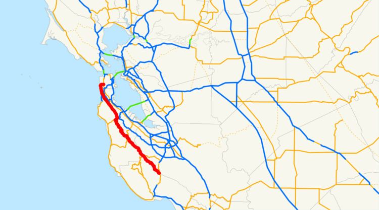
State Route 35 (SR 35) in the U.S. state of California, generally known as Skyline Boulevard, is a two-lane road running mostly along the ridge of the Santa Cruz Mountains from Highway 17 in Santa Clara County to San Francisco at State Route 1. Because of its high elevation and location, it is one of the few places on the southern portion of the San Francisco Peninsula from which the San Francisco Bay and the Pacific Ocean are both visible at the same time. It also provides scenic views of the Silicon Valley Metropolitan Area.
Contents
- Map of Skyline Blvd California USA
- Route description
- Recreational use
- Other landmarks
- History
- Major intersections
- References
Map of Skyline Blvd, California, USA
It was originally designated State Route 5, but this was changed with the creation of Interstate 5 in 1964, to avoid confusion.
Route description
This route is part of the California Freeway and Expressway System and is eligible for the State Scenic Highway System. However, only the portion from the Santa Cruz-Santa Clara County line to the SR 92 junction is actually a state scenic highway.
The highway begins at the junction of Summit Road and State Route 17. It bears the name Skyline Boulevard for a majority of its route along the ridge of the Santa Cruz Mountains to the west of Silicon Valley, passing cities such as San Jose, Saratoga, and Palo Alto. The southern portion of the road, starting at Highway 17 and ending at Black Road, is mostly a narrow and winding country road without a double-yellow line. From Black Road going north the road has been upgraded. The road reaches its highest elevation near Sanborn Skyline County Park at about 3,000 ft (914 m). The ridge that the road follows forms the border between Santa Cruz and Santa Clara counties. However, the boundary is so irregular that the road weaves in and out of the two counties.
The ridgetop portion of the route ends at the junction with State Route 92, because this northern area of the Santa Cruz Mountains is a protected watershed owned by the San Francisco Water Department. Highway 35 is co-routed with SR 92 for 2 miles (3 km) east, descending towards Crystal Springs Reservoir, which it crosses on a causeway, and then joins Interstate 280 northbound for 6 miles (10 km). However, on the southbound side, Route 35 exists as a separate road to the west of the freeway between Bunker Hill Dr. and Route 92, as there is no connector road between 280 South and 92 West.
Route 35 departs from 280 at the southern end of San Bruno, running to the west of the freeway, regaining the ridgetop separating South San Francisco and Daly City from Pacifica.
It crosses State Route 1 in Daly City and in San Francisco, Skyline Boulevard ends and the highway briefly continues along Sloat Boulevard until it reaches its terminus when it intersects Highway 1 again at 19th Avenue.
Recreational use
Because of its scenic views and winding roadway, Skyline Boulevard and surrounding roads see substantial recreational motoring and bicycling use. Many sports cars and motorcycles can be found congregating near the intersections with State Route 9 and State Route 84, particularly on weekends. Mountain bikers are also commonly found at the many trailheads along the road.
Several public open spaces border on Skyline Boulevard, including Sanborn County Park, Windy Hill, and the Purisima Open Space; both the latter are parts of the Midpeninsula Regional Open Space District. Numerous hiking trails originate from parking lots off Skyline in these open spaces.
Whenever there is snow on the road's higher elevations, many people take their families up to see and play in the snow, and therefore, many of the parking lots at regional parks are packed with cars.
Other landmarks
For most of the route, State Route 35 offers vistas of both Silicon Valley's skyline, and also the Pacific Ocean. The route passes through many of the wildlife refuges along the ridge of Silicon Valley and other parks:
A number of streams originate near Skyline Boulevard, flowing to both Pacific Ocean and the Bay. Among the bayside streams are San Francisquito Creek, Redwood Creek, and San Bruno Creek.
History
As old highway maps show, State Route 35 was originally designated State Route 5. The number was changed in the 1964 renumbering. The original state route 35 was located in southern California and ran north to south from State Route 22 to U.S. 99, first along Los Alamitos Blvd. going north which turns into Norwalk Blvd. The highway continued west on Centralia Road and then north along Pioneer Blvd. until hitting San Antonio drive at Rosecrans Ave. San Antonio Dr. would turn back into Norwalk blvd. and Route 35 would continue turning into Old Mill Road at Beverly Blvd. Route 35 would wind through Rose Hills and Avocado Heights as Workman Mill Rd. and would then turn into Puente Ave. at Valley Blvd. and continue to Route 99 where Route 35 ended at the border of Baldwin Park and West Covina.
Major intersections
Except where prefixed with a letter, postmiles were measured on the road as it was in 1964, based on the alignment that existed at the time, and do not necessarily reflect current mileage. R reflects a realignment in the route since then, M indicates a second realignment, L refers an overlap due to a correction or change, and T indicates postmiles classified as temporary (for a full list of prefixes, see the list of postmile definitions). Segments that remain unconstructed or have been relinquished to local control may be omitted. The numbers reset at county lines; the start and end postmiles in each county are given in the county column.