
Length 154.5 km | ||
 | ||
Restrictions: Special restrictionsNo hazardous material in the Sunol Valley between SR 238 and I-680No tractor-trailers or vehicles over 16.25 tons on the Ryer Island Ferry. Length restrictions may also apply. Majorjunctions: North end: | ||
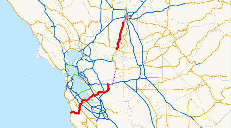
State Route 84 (SR 84) is a split-section California State Highway consisting of two sections. The first section is an east–west arterial road running from San Gregorio to Menlo Park, across the Dumbarton Bridge through Fremont and Newark and ending at I-580 in Livermore. The route overlaps the freeway segment of US 101 between Woodside Road in Redwood City and Marsh Road in Menlo Park. The segment between Marsh Road and the Dumbarton Bridge has been upgraded to an expressway and is known as the Bayfront Expressway. The segment from the eastern end of the Dumbarton Bridge to the interchange with I-880 has been upgraded to a freeway.
Contents
Map of CA-84, California, USA
The other section is a north-south arterial road that begins at SR 12 in Rio Vista, passes through Ryer Island (where it connects to SR 220), and ends at the I-80 interchange in West Sacramento. A ferry provides the crossing over Cache Slough from Rio Vista to Ryer Island. The ferry, a diesel-powered boat operated by Caltrans, is in operation twenty-four hours per day and charges no toll.
Route 84 is legally defined to continue from I-580 to SR 4 in Antioch, but there are currently no plans in place to bridge the gap at this time. A plan to build a $600 million toll road called the Mid-State Tollway along the proposed route was suspended in 2001 due to local opposition.
Route description
This route is part of the California Freeway and Expressway System and is eligible for the State Scenic Highway System. It is designated as a State Scenic Highway from SR 238 to I-680 in Alameda County.
The route begins at SR 1 on the Pacific coast near San Gregorio. It then heads northeast through San Mateo County crossing the Santa Cruz Mountains. As it enters Woodside, where it intersects SR 35, also known as Skyline Boulevard, then I-280. It then enters Redwood City, where it intersects SR 82, which carries El Camino Real through the South Bay. A few miles later, it interchanges with US 101, which it overlaps for a few miles. Upon routing eastward, it enters the city of Menlo Park as an expressway, called the Bayfront Expressway where it intersects SR 114 and SR 109 at grade intersections. The SR 114 (Willow Road) intersection was the site of the car crash in which author David Halberstam was killed on April 23, 2007.
SR 84 then becomes a freeway at the south end of San Mateo County as it crosses as the Dumbarton Bridge over the San Francisco Bay. Midway over the bridge, it enters Alameda County. In Alameda County, it runs northward through the city of Newark, where it begins a concurrency southwards with I-880 for about one mile. Both interchanges with I-880 are partial cloverleaf interchanges. Upon separation, the route isn't upgraded to freeway standards as it enters the city of Fremont, following the streets of Thornton Boulevard, Fremont Blvd, Peralta Blvd, and Mowry Ave, which after, it has a short concurrency northwards with SR 238. SR 84 then leaves Fremont through the historic Sunol Valley. After exiting the valley, it begins an overlap with I-680. After separating, it runs for several miles over a pass, then enters the city of Livermore; it runs along Isabel Ave until it meets I-580, as the end of its southern section. SR 84 is unconstructed from I-580 to SR 12.
The second section of SR 84 starts in Rio Vista at SR 12. It then follows the Ryer Island Ferry, which carries the route across the Cache Slough. When it leaves the ferry, it intersects SR 220. It continues northward and meets the end of state maintenance at the West Sacramento city limit, about six miles east of an intersection with CR E19. It then enters the city of West Sacramento in Yolo County. It then interchanges with I-80 Business, also signed as US 50. As it continues northward, it ends at I-80. From north of West Sacramento, SR 84 has been relinquished and given to the city of West Sacramento in 2003.
Major intersections
Except where prefixed with a letter, postmiles were measured on the road as it was in 1964, based on the alignment that existed at the time, and do not necessarily reflect current mileage. R reflects a realignment in the route since then, M indicates a second realignment, L refers an overlap due to a correction or change, and T indicates postmiles classified as temporary (for a full list of prefixes, see the list of postmile definitions). Segments that remain unconstructed or have been relinquished to local control may be omitted. The numbers reset at county lines; the start and end postmiles in each county are given in the county column.