
Country United Kingdom | ||
 | ||
Mountains Similar Dumyat, Wallace Monument, Castle Campbell, Abbey Craig, Gleneagles Hotel | ||
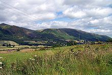
Glen sherup ochil hills
The Ochil Hills (/ˈoʊxəl/; Scottish Gaelic: Monadh Ochail - from a Celtic word root, compare Old Welsh uchel meaning 'high') is a range of hills in Scotland north of the Forth valley bordered by the towns of Stirling, Alloa, Kinross, Auchterarder and Perth. The only major roads crossing the hills pass through Glen Devon/Glen Eagles and Glenfarg, the latter now largely replaced except for local traffic by the M90 Edinburgh-Perth motorway cutting through the eastern foothills. The hills are part of a Devonian lava extrusion whose appearance today is largely due to the Ochil Fault which results in the southern face of the hills forming an escarpment. The plateau is undulating with no prominent peak, the highest point being Ben Cleuch at 721 m The south-flowing burns have cut deep ravines including Dollar Glen, Silver Glen and Alva Glen, often only passable with the aid of wooden walkways.
Contents
- Glen sherup ochil hills
- Map of Ochil Hills Dollar UK
- Ochil hills glen quey
- Proposed wind farms
- Selection of summits in the Ochil Hills
- References
Map of Ochil Hills, Dollar, UK
Historically, the hills, combined with the town being built at the lowest bridge-point on the River Forth, led to Stirling's importance as a main gateway to the Highlands. They also acted as a boundary to the Kingdom of Fife. Castle Campbell was built at the head of Dollar Glen in the late 15th century (an earlier castle on the site being called "Castle Gloom") mainly as a very visible symbol of the Campbell domination of the area. Sheriffmuir, the site of the 1715 battle of the Jacobite rising is on the northern slopes of the hills. In the early Industrial Revolution, several mill towns such as Tillicoultry, Alva and Menstrie (the Hillfoots Villages) grew up in the shadow of the Ochils to tap the water power. Some of the mills are open today as museums.
Blairdenon Hill was the site of one of the Beacons of Dissent during the G8 protests in July 2005.
Ochil hills glen quey
Proposed wind farms
A proposal for an 18 turbine development at Green Knowes, south of Auchterarder, north of Glendevon was approved in June 2006. The development will be situated about 400 m north of the Ben Thrush summit. This is now complete.
In early 2007 approval was given for the construction of a wind farm consisting of thirteen 102 m (334 ft) turbines on Burnfoot Hill, which lies north of Tillicoultry and Ben Cleuch and to the south of the Upper Glendevon Reservoir. Construction of this site has begun.
Selection of summits in the Ochil Hills
Seamab Hill