
 | ||
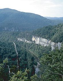
The Boston Mountains range is a high and deeply dissected plateau located in northern Arkansas and eastern Oklahoma. The Oklahoma portion of the range is locally referred to as the Cookson Hills. The range covers an area of 5,770 square miles (14,900 km2). The rocks of the region are essentially little disturbed, flat-lying sedimentary layers of the Paleozoic age. The highest ridges and peaks are capped by Pennsylvanian sandstone and shale. The deeply eroded valleys are cut into Mississippian limestones and below that layer Ordovician dolomites.
Contents
General descriptionEdit
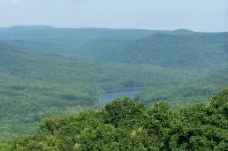
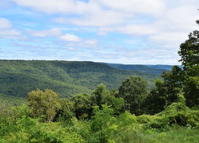
The Boston Mountains form the southwestern part of the Ozark plateau where they are the highest, most rugged, and least denuded portion of the Ozarks, owing to their young age relative to the other sections. Summits can reach elevations of just over 2,560 feet (780 m) with valleys 500 feet (150 m) to 1,550 feet (470 m) deep. Turner Ward Knob (TWK) is the highest named peak. Located in western Newton County, Arkansas, its elevation is 2,463 feet (751 m). Nearby, five unnamed peaks have elevations at or slightly above 2,560 feet (780 m). Two of these highest peaks are located 2.2 miles (3.5 km) west of Turner Ward Knob, one being the location of the Buffalo Lookout fire tower at 2,561 feet (781 m). The other three highest peaks are located 4–5 miles (6.4–8.0 km) southsouthwest of Turner Ward Knob along Arkansas Highway 16.
Rivers and streamsEdit
The Boston Mountains are the source of rivers and streams that flow out from the mountains in all directions. Within a 3 miles (4,800 m) radius of a point just west of the summits discussed above are located the sources of the White River, the Buffalo River, the Kings River, War Eagle Creek, and Little Mulberry Creek. Other rivers and streams having their headwaters in the Boston Mountains include the Illinois River, the Mulberry River, Lee Creek, Frog Bayou, Big Piney Creek, Illinois Bayou, and the Little Red River. To the south, the Arkansas River valley separates the Boston Mountains from the Ouachita Mountains.
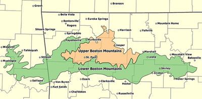
In Arkansas, the Boston Mountains are found in the following counties: Boone, Carroll, Cleburne, Conway, Crawford, Franklin, Independence, Johnson, Madison, Marion, Newton, Pope, Searcy, Stone, Van Buren, and Washington.
In Oklahoma, the Boston Mountains are found in these counties: Adair, Cherokee, Muskogee, Sequoyah, and Wagoner.
Geology and physiographyEdit
The Boston Mountains are a physiographic section of the larger Ozark Plateaus province, which in turn is part of the larger Interior Highlands physiographic division.
The area is underlain by Pennsylvanian sandstone, shale, and siltstone, where some folding and faulting has occurred. The sandstone beds become thinner, but more shaly in the west as the mountains decline in elevation.