
Length 39 mi (63 km) Elevation 1,116 m | Country United States | |
 | ||
Similar Hoye‑Crest, Mount Davis, Woodall Mountain, Campbell Hill, Ebright Azimuth | ||
Backbone mountain
Backbone Mountain is a ridge of the Allegheny Mountains of the central Appalachian Mountain Range. It is situated in the U.S. states of West Virginia and Maryland and forms a portion of the Eastern Continental Divide. In the state of Maryland, Backbone Mountain reaches an elevation of 3,360 feet, making it Maryland's highest mountain.
Contents
- Backbone mountain
- Map of Backbone Mtn Fairfax WV 26269 USA
- 3 360 feet above sea level at backbone mountain in maryland on mmusa
- Description and geographyEdit
- Hoye CrestEdit
- Olson Observation TowerEdit
- Crabtree WoodsEdit
- References
Map of Backbone Mtn, Fairfax, WV 26269, USA
3 360 feet above sea level at backbone mountain in maryland on mmusa
Description and geographyEdit
Backbone Mountain stretches approximately 39 miles (63 km) southwest to northeast, from the Black Fork near Hambleton in Tucker County, West Virginia to the Savage River Reservoir in Garrett County, Maryland.
The mountain provides a boundary between two watersheds. The headwaters of Youghiogheny River, in the watershed of the Mississippi River, lie just northwest of the mountain, whereas the headwaters of the North Branch of the Potomac River lie just south of the mountain, along the West Virginia-Maryland border.
The ridge is crossed twice by U.S. Route 219, once north of Parsons and again near Silver Lake. It is also crossed by U.S. Route 50 east of Red House, Maryland, which is marked by a Maryland State Highway Administration sign.
Hoye-CrestEdit
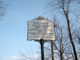
Located just inside of Maryland along Backbone Mountain is Hoye-Crest. At an elevation of 3,360 feet (1,020 m), it is the highest point in the state of Maryland. The location, named for Captain Charles Hoye, founder of the Garrett County Historical Society, has a marker and offers a view of the North Branch Potomac River valley to the east. The location is accessible via a path leading from U.S. Route 219 to the west.
Olson Observation TowerEdit
The southern end of Backbone Mountain was the location of West Virginia's first fire tower. The first tower was built in 1922 by the state and subsequently transferred to Monongahela National Forest. In 1963, the original tower was replaced with the one currently on-site and named after Ernest B. Olson in recognition of 28 years of service in MNF fire control and conservation programs.
While the cab of the tower is not open to the public, the 133 steps leading to it are. The tower provides spectacular views of the areas including Cheat River watershed, Parsons, Blackwater Canyon, Canaan Mountain and the Otter Creek Wilderness.
Crabtree WoodsEdit
Crabtree Woods, on the northwest slopes of Backbone Mountain, is in the Potomac-Garrett State Forest. It constitutes Maryland's largest surviving remnant of old-growth forest: over 500 acres (2.0 km2) of mixed Appalachian hardwoods (sugar maple, red oak, basswood and cucumber tree).