
Country United States Incorporated (city) 1907-02-18 Elevation 502 m Population 1,430 (2013) Area code 304 | Incorporated (town) 1893-06-12 Named for Ward Parsons Zip code 26287 Local time Thursday 3:32 PM | |
 | ||
Weather 12°C, Wind SE at 6 km/h, 18% Humidity Area 3.108 km² (2.875 km² Land / 23 ha Water) | ||
Parsons is a city in and the county seat of Tucker County, West Virginia, United States. The population was 1,485 at the 2010 census. The mayor of Parsons is Dorothy Judy and the city administrator is Jason Myers. The city is also governed by a city council.
Contents
- Map of Parsons WV USA
- History
- 1985 flood
- Historic sites
- Geography
- Climate
- 2010 census
- 2000 census
- References
Map of Parsons, WV, USA
History
Parsons was created in Southern Tucker County. The town was named for Ward Parsons, described by one source as having once owned the land on which the town was built, and by another as having been an aged wilderness pioneer in the area.
The West Virginia Central and Pittsburg Railway was built into Parsons in 1888. The railway caused the town to boom by the 1890s. The railway was later merged into the Western Maryland Railway and provided passenger train service until the 1950s.
In the early 1890s, a dispute known as the Tucker County Seat War took place between the people in the town of Parsons and that of St. George over the location of the county seat. Although nobody was killed in the "war," the situation came to a climax when a mob of armed men from Parsons marched on St. George and took the county records by force.
1985 flood
The 1985 Cheat River flood caused extensive damage in Parsons. Over 90 percent of the businesses and hundreds of homes were damaged or destroyed. Twenty-five years later, in 2010, several empty storefronts lined the street up to the courthouse. Bars, restaurants, clothing stores and other businesses never returned to Parsons. The floods caused an estimated $570 million in damages. More than 3,500 homes and 180 businesses were destroyed. The BF Long & Co general store had a "high water mark" more than 7'6" from the floorboards. Flood stage in the shallow riverbed was only 7 feet.
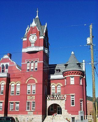
Historic sites
Located at Parsons and listed on the National Register of Historic Places are the Tucker County Bank Building, Tucker County Courthouse and Jail, and Western Maryland Depot.
Geography
Parsons is located at 39°5′45″N 79°40′46″W (39.095721, -79.679465). The Cheat River is formed at Parsons by the confluence of the Shavers Fork and the Black Fork.
The city has a total area of 1.20 square miles (3.11 km2), of which, 1.11 square miles (2.87 km2) is land and 0.09 square miles (0.23 km2) is water.
Climate
The climate in this area has mild differences between highs and lows, and there is adequate rainfall year round. According to the Köppen Climate Classification system, Parsons has a marine west coast climate, abbreviated "Cfb" on climate maps.
2010 census
As of the census of 2010, there were 1,485 people, 628 households, and 419 families residing in the city. The population density was 1,337.8 inhabitants per square mile (516.5/km2). There were 730 housing units at an average density of 657.7 per square mile (253.9/km2). The racial makeup of the city was 98.8% White, 0.1% African American, 0.1% Native American, and 1.1% from two or more races. Hispanic or Latino of any race were 0.8% of the population.
There were 628 households of which 29.8% had children under the age of 18 living with them, 50.3% were married couples living together, 10.8% had a female householder with no husband present, 5.6% had a male householder with no wife present, and 33.3% were non-families. 29.3% of all households were made up of individuals and 15.4% had someone living alone who was 65 years of age or older. The average household size was 2.36 and the average family size was 2.87.
The median age in the city was 42.7 years. 22.7% of residents were under the age of 18; 6.7% were between the ages of 18 and 24; 24.4% were from 25 to 44; 26.4% were from 45 to 64; and 19.9% were 65 years of age or older. The gender makeup of the city was 48.7% male and 51.3% female.
2000 census
As of the census of 2000, there were 1,463 people, 642 households, and 426 families residing in the city. The population density was 1,332.5 people per square mile (513.5/km²). There were 731 housing units at an average density of 665.8 per square mile (256.6/km²). The racial makeup of the city was 98.97% White, 0.21% Native American, 0.07% from other races, and 0.75% from two or more races. Hispanic or Latino of any race were 0.34% of the population.
There were 642 households out of which 27.4% had children under the age of 18 living with them, 52.5% were married couples living together, 10.3% had a female householder with no husband present, and 33.5% were non-families. 29.9% of all households were made up of individuals and 14.5% had someone living alone who was 65 years of age or older. The average household size was 2.28 and the average family size was 2.82.
In the city, the population was spread out with 22.4% under the age of 18, 6.7% from 18 to 24, 27.8% from 25 to 44, 25.2% from 45 to 64, and 18.0% who were 65 years of age or older. The median age was 40 years. For every 100 females there were 89.5 males. For every 100 females age 18 and over, there were 86.8 males.
The median income for a household in the city was $26,424, and the median income for a family was $31,645. Males had a median income of $22,331 versus $20,069 for females. The per capita income for the city was $16,565. About 16.1% of families and 18.7% of the population were below the poverty line, including 22.7% of those under age 18 and 13.0% of those age 65 or over.