
Existed: 1961 – present Length 248.4 km | Constructed 1961 | |
 | ||
East end: NM 264 near Window Rock | ||
State Route 264 (SR 264) is a highway in northeastern Arizona that runs from its junction with US 160 in Tuba City to the border with New Mexico. The roadway is still numbered 264 into New Mexico to its junction with US 491.
Contents
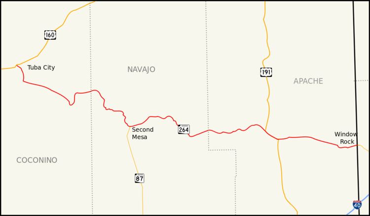
Map of AZ-264, United States
Route description
The western terminus of SR 264 is located at a junction with US 160 in Tuba City. The highway heads towards the southeast and then south from this junction until it reaches BIA Route 6710. At this junction, SR 264 begins to heads towards the southeast. It continues on this heading until it curves towards the south southeast of Coal Mine Mesa. The highway curves back towards the east and then north as it follows the terrain of the area. The highway curves back towards the east just prior to an intersection with BIA Route 6660. It continues towards the east to a junction with BIA Route 62 where SR 264 curves towards the southeast. The highway curves towards the south just prior to passing through Hotevilla. It curves back towards the east when it reaches Old Oraibi. The highway curves back towards the south until it reaches the northern terminus of SR 87 in Second Mesa. From here, it heads east, passing through Polacca and Keams Canyon. SR 264 continues to the southeast until it curves back toward the east at an intersection with BIA Route 6. SR 264 continues east to a junction with US 191 in Burnside and the two run concurrently until they reach Ganado. US 191 heads south from this junction as SR 264 heads east. SR 264 continues east to Window Rock just prior to crossing the New Mexico border and continuing as New Mexico State Road 264.
SR 264 is one of two major east–west routes crossing the expansive Navajo Indian Reservation, the other being US 160. Most significantly the road links together the numerous villages of the Hopi Indian Tribe and bisects the Hopi Reservation. In fact, navigating the Hopi Reservation would be impossible without the existence of this roadway. It connects all 12 Hopi and Tewa villages and provides access to all Hopi governmental buildings. Much of this territory is sparsely inhabited and is home to wide open, scenic vistas. While it does not pass through any large cities or towns, it does pass through Window Rock, seat of government for the Navajo Nation, as well as near Old Oraibi, which is generally considered the oldest continuously inhabited settlement in North America.
History
Although SR 264 became a state highway in 1961, maps of the area would indicate that the route itself has existed as a dirt road as early as 1927. By 1935, portions of the route had been improved. The section between Oraibi and Keams Canyon and the section from northwest of Ganado and the New Mexico border had been improved for travel. By 1938, the route had been improved further to a gravel road. By the time the route became a state highway in 1961, the route had been paved.