
FIPS code 04-83720 Elevation 2,082 m Zip code 86515 Population 2,712 (2010) | State Arizona Time zone MST (UTC-7) GNIS feature ID 0013908 Navajo Nation Area code Area code 928 | |
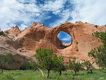 | ||
Window rock arizona
Window Rock (Navajo: Tségháhoodzání) is a small city that serves as the seat of government and capital of the Navajo Nation, the largest territory of a sovereign Native American nation in North America. It lies within the boundaries of the St. Michaels Chapter, adjacent to the Arizona and New Mexico state line. Window Rock hosts the Navajo Nation governmental campus which contains the Navajo Nation Council, Navajo Nation Supreme Court, the offices of the Navajo Nation President and Vice President, and many Navajo government buildings.
Contents
- Window rock arizona
- Map of Window Rock AZ USA
- Origin of name
- Government
- Geography
- Features
- Demographics
- Education
- Travel and tourism
- Navajo Nation Museum
- Navajo Nation Zoological and Botanical Park
- Chihootso Indian Market Place
- Transportation
- Business
- Culture
- Health care
- References
Map of Window Rock, AZ, USA
Window Rock's population was 2,712 at the 2010 census., but is estimated to reach around 20,000 during weekdays when tribal offices are open. Window Rock's main attraction is the window formation of sandstone the community is named after. The Navajo Nation Museum, the Navajo Nation Zoological and Botanical Park, and the Navajo Nation Code Talkers World War II memorial are located in Window Rock.
Origin of name
Until 1936, the area was sparsely populated and known only by its ceremonial name Niʼ Ałníiʼgi ("Center of the World"). John Collier, Commissioner of Indian Affairs, chose the site to establish the seat of the Navajo Central Agency. His proposal to make the ceremonial name the official name met with resistance and Navajos soon ridiculed it as "ni ałnííʼgóó" (~ "into your middle (parts)").
Due to this, the name of the major local landmark, the rock-with-hole-through-it (Navajo: tségháhoodzání) was chosen and rendered in English as "Window Rock".
Tségháhoodzání (the Perforated Rock), which is north of the Navajo governmental administration buildings, is important in the traditional Navajo Water Way Ceremony (Tóee). It was one of the four places where Navajo medicine men go with their traditional woven water jugs to get water for the ceremony that is held for the abundance of rainfall.
Government
As a district within the St. Michaels Chapter, Window Rock is served by a Navajo Council Delegate and Chapter President and Vice President. Although Window Rock is within St. Michaels Navajo Chapter it is the capital of the Navajo Nation government which houses the Navajo Nation President and Vice President, Navajo Nation Supreme Court, the 24-member Navajo Nation Council, and Navajo government administration buildings.
Geography
Window Rock is located at 35°40′22″N 109°3′44″W (35.672752, -109.062097). The Arizona/New Mexico state line marks the town's eastern edge, and some of the town's buildings are located a few feet (meters) from the state line.
According to the United States Census Bureau, the Window Rock CDP (census designated place) has a total area of 5.3 square miles (13.7 km2), all land.
The area is atop the Defiance Plateau which encompasses the area.
Features
The greater Window Rock area comprises the Fort Defiance and St. Michaels chapters, the hamlets of Hunter's Point and the Summit, and Tse Bonito on the New Mexico side of the border with Arizona.
Demographics
As of the census of 2000, there were 3,059 people, 876 households, and 713 families residing in the CDP. The population density was 589.3 people per square mile (227.6/km2). There were 998 housing units at an average density of 192.3/sq mi (74.2/km2). The racial makeup of the CDP was 95.46% Native American, 3.17% White, 0.42% Asian, 0.16% African American, 0.03% Pacific Islander, 0.07% from other races, and 0.69% from two or more races. Hispanic or Latino of any race were 1.44% of the population.
There were 876 households out of which 51.0% had children under the age of 18 living with them, 43.7% were married couples living together, 29.7% had a female householder with no husband present, and 18.6% were non-families. 15.6% of all households were made up of individuals and 2.4% had someone living alone who was 65 years of age or older. The average household size was 3.42 and the average family size was 3.81.
In the CDP, the age distribution of the population shows 36.3% under the age of 18, 10.9% from 18 to 24, 28.7% from 25 to 44, 19.6% from 45 to 64, and 4.5% who were 65 years of age or older. The median age was 27 years. For every 100 females there were 92.6 males. For every 100 females age 18 and over, there were 88.4 males.
The median income for a household in the CDP was $36,885, and the median income for a family was $36,500. Males had a median income of $27,266 versus $26,902 for females. The per capita income for the CDP was $11,122. About 24.6% of families and 24.6% of the population were below the poverty line, including 28.6% of those under age 18 and 6.8% of those age 65 or over.
Education
Window Rock is a part of the Window Rock Unified School District, which serves the greater Fort Defiance and St. Michaels chapters population center.
Window Rock is served by:
The community is also served by the private Saint Michael Indian School, a K-12 private, Catholic school established by Katharine Drexel in 1902. Saint Michael Indian School is a member of the National Catholic Education Association and the Diocese of Gallup Catholic School System.
The surrounding community is also served by the Hilltop Christian School, operated by the Western Indian Ministries offering pre-K through 6th grade learning curriculum.
In addition, the Saint Michaels Association for Special Education, Inc. (SMASE) school serves the greater Navajo Nation in Arizona and New Mexico. A non-profit school, founded by Sister Marijane Ryan in 1970 serves as an educational and residential center for individuals with disabilities of all ages.
Travel and tourism
Tourism is an integral part of the local economy. Window Rock attracts a large number of tourists and visitors due to its close proximity to many national parks and sites and Navajo government. The area is a popular base of commerce for the regional people as well.
Window Rock is within driving distance to:
Navajo Nation Museum
In the year of 1961 the Navajo Tribe established the first Navajo Tribal Museum in a small building on the Window Rock Tribal Fairgrounds. It was moved in 1982 to the back room of the Navajo Arts and Crafts Store. In 1997, a $7 million permanent home was built to store the Navajo artifacts in a museum specially built in a modern Navajo hogan style near the Navajo Nation Zoo. The Navajo Nation Museum and its colocated Library offer many relics and artifacts of the Navajo people and Navajo Nation, many resources on the Navajo people, language and ceremonies are also offered in the Navajo Nation Library which is adjacent to the museum. The museum is open Monday through Friday and is free to the public.
Navajo Nation Zoological and Botanical Park
The Navajo Tribal Zoo opened in Window Rock in 1963 featuring reservation animals such as bear, coyotes, snake, elk, and the golden eagle. The Navajo Nation Zoological and Botanical Park offers a wide variety of plants, animals, fishes, birds and insects native to the Four Corners area of the Navajo Nation such as elk, mule deer, Mexican gray wolf, black bear, cougar, golden eagle, bighorn sheep, lynx, Rio Grande wild turkey, raccoon, Canadian goose, and fox. The Navajo Nation Zoo is open Monday through Saturday and is free to the public.
Ch'ihootso Indian Market Place
The Ch'ihootso Market Place offers many vendors with Navajo arts and crafts along with Hopi, Zuni and local artists. The market place is open from 5:00 am to 6:00 pm Monday through Sunday.
Transportation
Window Rock is served by Arizona State Route 264, and Indian Route 12 .
Window Rock is served by a local regional airport : Window Rock Airport. Window Rock Airport is a public use airport located one nautical mile south of the central business district of Window Rock, in Apache County. It is owned by the Navajo Nation.
Local transportation is provided by the Navajo Nation Transit System which operates from Window Rock. It provides several routes that serve the community, the Navajo Nation, the Hopi Nation, and San Juan Southern Paiute Tribe.
Business
Window Rock is served by two regional shopping centers: Diné Bashas' and Lowe's Market. The Navajo Nation Shopping Center Enterprise also serves the area.
Culture
Numerous events are hosted throughout the year in the greater Window Rock area, which includes Fort Defiance and St. Michaels, such as:
Health care
Window Rock is served by the Tsehootsooi Medical Center. Located in Fort Defiance, Arizona also serves the Window Rock and the surrounding area.
Tsehootsooi Medical Center(Fort Defiance Indian Hospital fdihb.org/ ) | Nahat'a Dziil Health Center - Provides excellent health care services... Where you are always Welcome! Contact UsBy email, phone, etc...
Contact us (928)729-8000, P.O. Box 649, Fort Defiance, AZ 86504 ... Contact UsBy email ... More results from fdihb.org »