
OS grid SH827370 Elevation 854 m Mountain range Arenigs | Location Gwynedd, Wales Topo map OS Landranger 124 Prominence 479 m | |
 | ||
Listing Marilyn, Hewitt, Nuttall Similar | ||
Wales 2013 episode 3 llyn arenig fawr and y castell
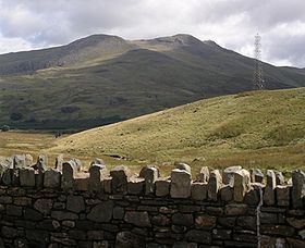
Arenig Fawr (English: Great High Ground) is a mountain in Snowdonia, North Wales, located close to Llyn Celyn reservoir alongside the A4212 between Trawsfynydd and Bala.
Contents
- Wales 2013 episode 3 llyn arenig fawr and y castell
- Map of Arenig Fawr Bala UK
- LocationEdit
- AscentEdit
- RailwayEdit
- Art and literatureEdit
- References
Map of Arenig Fawr, Bala, UK
LocationEdit
Arenig Fawr is the highest member of the Arenig range with Arenig Fach (English: Small High Ground), a smaller neighbouring mountain, lying to the north. It is surrounded by Moel Llyfnant to the west, Rhobell Fawr to the south and Mynydd Nodol to the east.
AscentEdit
The easy-to-moderate climb to the summit takes about 2½ hours from Llyn Celyn. There are no readily identifiable footpaths but the route is marked by an old wire boundary fence. Beneath the mountain is Llyn Arenig Fawr, a reservoir which provides drinking water to Bala and the surrounding villages.
The summit, which is also known as Moel yr Eglwys (English: Bare hill of the church), has a trig point and a memorial to eight American aircrew who died when their Flying Fortress bomber B-17F #42-3124 crashed on 4 August 1943. Some of the crash wreckage is still scattered across the hillside 300m from the memorial location.
From the summit, with good weather conditions, it is possible to see several notable Welsh mountain ranges: the Rhinogs in the west, Snowdon to the northwest, Clwydian Hills in the northeast, east to the Berwyns, south east to the Arans, and southward to Cadair Idris. It is one of the finest panoramas in Wales.
RailwayEdit
Arenig Halt was a request stop on the Bala Ffestiniog Line. It closed to passenger services on 2 January 1960 and freight services on 27 January 1961. The remains of the station buildings have been totally cleared away leaving no trace.
Art and literatureEdit
Artists James Dickson Innes and Augustus John used the mountain as a backdrop during their two years of painting in the Arenig valley between 1911-12. In 2011 their work was the subject of a BBC documentary entitled The Mountain That Had to Be Painted.
In The Faerie Queene, an incomplete English epic poem, by Sir Edmund Spenser, the home of 'old Timon', Prince Arthur’s sage foster-father "is low in a valley greene, | Under the foot of Rauran mossy hore". Renowned Welsh historian Sir John Edward Lloyd wrote that Rauran "comes from Saxton's map of Merionethshire (1578), which places ‘Rarau uaure Hill’ (Yr Aran Fawr) where Arenig should be".
A boulder at a crossroads in the hamlet of Bell Heath, near to Belbroughton, Worcestershire, in England, has a brass plaque attached to it stating "Boulder from Arenig Mountain in N. Wales, Brought here by the Welsh Ice-sheet in the Glacial Period".