
Elevation 893 m Easiest route Hiking | OS grid SH711130 Prominence 608 m | |
 | ||
Listing Marilyn, Hewitt, Nuttall Topo map OS Landranger 124, Explorer OL23 Mountain range Cadair Idris and the Tarren range, Cambrian Mountains Similar Snowdon, Cyfrwy, Diffwys, Aran Fawddwy, Pen y Fan | ||
Cadair Idris or Cader Idris is a mountain in Gwynedd, Wales, which lies at the southern end of the Snowdonia National Park near the town of Dolgellau. The peak, which is one of the most popular in Wales for walkers and hikers, is composed largely of Ordovician igneous rocks, with classic glacial erosion features such as cwms, moraines, striated rocks, and roches moutonnées.
Contents
- Map of Penygader Dolgellau UK
- Cadair idris mountain in wales best travel destination
- EtymologyEdit
- AscentEdit
- Pony PathEdit
- Foxs PathEdit
- Minffordd PathEdit
- GeologyEdit
- Myths legends and popular cultureEdit
- References
Map of Penygader, Dolgellau, UK
Cadair idris mountain in wales best travel destination
EtymologyEdit
Cadair Idris means 'Idris's Chair'. Idris is usually taken to be the name of a giant or, alternatively, it may refer to Idris ap Gwyddno (or Gweiddno), a 7th-century prince of Meirionnydd who won a battle against the Irish on the mountain. Idris ap Gwyddno was in fact referred to as Idris Gawr ("Idris the Giant") in some mediaeval genealogies of Meirionydd.
The basic meaning of the word cadair (Middle Welsh/Early Modern Welsh kadeir or cadeir) is 'seat, chair' (borrowed from the Latin cathedra 'chair'). In place names cadair can mean 'stronghold, fort, fortress' or 'mountain or hill shaped like a chair'. The spelling cader represents a spoken variant of the standard form cadair.
It appears that Cadair/Cadeir Idris is the form used in the earliest Welsh-language sources. In a poem in his own hand in the second half of the fifteenth century, the poet Lewys Glyn Cothi wrote 'Dros gadair idris gedy' ('and then over Cadair Idris'). Around 1600, John Jones of Gellilyfdy referred to 'y mynydh neu bhan neu bhoel a elwir Cadeir Idris' ('the mountain, peak or hill known as Cadeir Idris'.
The spoken form represented by cader had developed by the end of the Middle Ages and as a result the form Cader Idris was often used in English and Latin documents at that time and in more recent documents in English and Welsh.
In his Dictionarum Duplex published in 1632, John Davies of Mallwyd differentiated between the two words cadair ('chair') and cader ('fort, fortress'), referring to 'Cader Idris' and 'Cader Ddinmael'. That interpretation was followed by some later lexicographers, including Thomas Charles and Titus Lewis. It is now accepted, however, that cader is a spelling of a spoken form of cadair, and that there is no evidence that cadair and cader are separate words. But as it represents the pronunciation in the local dialect, the spelling Cader Idris is often seen in Welsh and English. In June 2016 Snowdonia National Park decided to adopt that spelling on its signage. The local dialect form is also seen in the name of the local secondary school, Ysgol y Gader. The name of the mountain is typically spelt Cadair Idris on current maps. The summit of the mountain is known as Penygader ("top of the chair/stronghold").
AscentEdit
There are three main trails that lead to the top of Cadair Idris. The summit, which is covered in scree, is marked by a trig point. There is also a low-standing stone shelter with a roof.
Pony PathEdit
The Pony Path (Welsh: Llwybr Pilin Pwn), which begins in the north from either Dolgellau or the Mawddach estuary, is the easiest but the longest of the main trails. Its length from the mountain's base is 5 kilometres (3.1 mi) with a 600 metres (2,000 ft) climb.
Fox's PathEdit
The Fox's Path (Welsh: Llwybr Madyn),This is the most direct way to the summit as the trail leads straight up the northern face. The 3.8 kilometres (2.4 mi) ascent involves a climb up a 310 metres (1,020 ft) cliff-scree face. However, this part of the Fox's Path has been heavily eroded in recent years making the descent dangerous.
Minffordd PathEdit
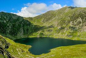
The Minffordd Path (Welsh: Llwybr Minffordd) starts on the southern side of the mountain near the glacial Tal-y-llyn Lake. Hikers using this ascent climb past Llyn Cau and along the rim of Craig Cau (rockwall) to Penygadair. Its length is 4.4 kilometres (2.7 mi) and involves two climbs of over 300 metres (980 ft).
GeologyEdit
The crater-like shape of Llyn Cau has given rise to the occasional mistaken claim that Cadair Idris is an extinct volcano. This theory was discounted as early as 1872, when Charles Kingsley commented in his book Town Geology :
The natural bowl-shaped depression was formed by a cirque glacier during the last ice age when snow and ice accumulated in the corries due to avalanches on higher slopes. In these depressions, snow persisted through summer months, and becomes glacial ice. The cirque was up to a square kilometre in size surrounded on three sides by steep cliffs. The highest cliff was the headwall. The fourth side was the "lip" from which the glacier flowed away from the cirque. Over thousands of years ice flowed out through the bowl's opening carving the chair of Cadair Idris.
As the glacier eroded the lip down to the bedrock, there are several tear-drop shaped hills above the edge of Llyn Cau. These geologically important rocky outcrops are called roche moutonnée (English: sheep-like rock) and were formed from the abrasive action of the ice. The two highest lakes are Llyn Cau and Llyn y Gader, it appears to have a maximum depth of about 13 m (43 ft).
Much of the area around Cadair Idris was designated a National Nature Reserve in 1957, and is home to Arctic–alpine plants such as purple saxifrage and dwarf willow .
Myths, legends and popular cultureEdit
There are numerous legends about Cadair Idris. Some nearby lakes are supposed to be bottomless, and anyone who sleeps on its slopes alone will supposedly awaken either a madman or a poet. This tradition (of sleeping on the summit of the Mountain) apparently stems from bardic traditions, where bards would sleep on the mountain in hope of inspiration.
Although the mountain's name is typically taken to refer to the mythological giant Idris, who was said to have been skilled in poetry, astronomy and philosophy, it has sometimes been mistranslated as Arthur's Seat, in reference to King Arthur (and to the hill of the same name in Edinburgh), an idea used by author Susan Cooper in her book The Grey King. However, this translation is mistaken and there is no etymological or traditional connection between Idris and Arthur.
In Welsh mythology, Cadair Idris is also said to be one of the hunting grounds of Gwyn ap Nudd and his Cŵn Annwn. The howling of these huge dogs foretold death to anyone who heard them, the pack sweeping up that person's soul and herding it into the underworld.
The mountain is mentioned several times and is used as a backdrop to the story of Mary Jones and her Bible. This story is an account of a girl from Llanfihangel-y-Pennant at the foot of the mountain who walked 25 miles to Bala in order to buy a bible, which were scarce at the time. Jones' determined journey to get hold of a copy of the book in 1800 was a major factor behind the foundation of the British and Foreign Bible Society in 1804.
Cadair Idris is where Will Herondale journeys to in order to attempt to rescue Tessa Gray, his love, from the evil Mortmain in Clockwork Princess, book three of The Infernal Devices by Cassandra Clare.
In "The Raven Cycle" by Maggie Stiefvater, Cadair Idris is mentioned in relation to Owain Glyndwr.
"Tongues of fire on Idris flaring" is mentioned in the opening verse of the John Guard version of Men of Harlech.