
Pronunciation Welsh: [ˈr̥ɔbɛɬ ˈvaur] OS grid SH786256 Elevation 734 m Mountain range Arenigs | Topo map OS Landranger 124 Prominence 309 m | |
 | ||
Listing Marilyn, Hewitt, Nuttall Similar Dduallt, Arenig Fawr, Moel Llyfnant, Aran Fawddwy, Rhinog Fawr | ||
Westons wales walks rhobell fawr the extinct volcano
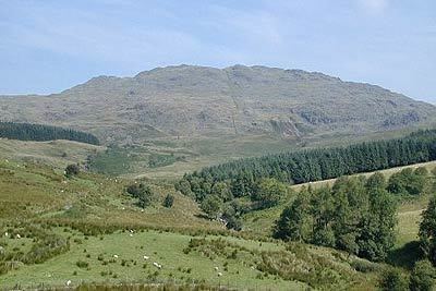
Rhobell Fawr is an extinct volcano in the Arenig range within the Snowdonia National Park.
Contents
- Westons wales walks rhobell fawr the extinct volcano
- Map of Rhobell Fawr Dolgellau UK
- Rhobell fawr fell run
- References
Map of Rhobell Fawr, Dolgellau, UK
Despite its modest height of 734 m (2,408 feet), it is a mountain with views of higher peaks all around, including the north face of Cadair Idris and distant Snowdon.
The paths are not well trodden, but there is a distinct path up from Bwlch Goriwared, a couple of miles north-north-east of the small village of Llanfachreth. From the pass (SH764246) a ladder-stile crosses a wall beside some sheep-folds on the eastern side of the track. A path follows a wall eastwards for a little more than 2 miles to the summit. The walk can easily be done, there and back from Llanfachreth, in 4 hours, given good weather, and provided you are used to the British mountains and reasonably fit.
A more arduous ascent is a circuit starting at Cwm yr Allt-lwyd. A good path crosses the infant Afon Mawddach, a switchback rises high above the river and then drops to ford it, from where a fence is followed to the neighbouring summit of Dduallt. From there, descend to the forest, which is entered at a corner (SH804259). The forest is extremely dense, but soon a firebreak is reached and this is followed until a forestry track is seen at the edge of the forest (SH797250). Follow this track south-west to a wall (SH792247), turn right and stay by the wall all the way to the summit. The descent is arduous and involves much struggling through heather and bog until finally a path is picked up. The whole walk should take about six hours.