
Opening date 1950 Height 139 m Opened 1950 | Length 411 m Construction began 1941 | |
 | ||
Creates Anderson Ranch Reservoir Total capacity 503,500 acre feet (0.621 km) Catchment area 960 square miles (2,490 km) Operator United States Bureau of Reclamation Similar Arrowrock Dam, Lucky Peak Dam, Boise National Forest, Lucky Peak State Park, Deadwood Reservoir | ||
Anderson ranch dam aerial footage
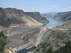
Anderson Ranch Dam is an earth rockfill type dam on the South Fork of the Boise River, in Elmore County, Idaho, United States. Its reservoir, Anderson Ranch Reservoir, has a spillway elevation of 4,196 feet (1,279 m) above sea level. The dam is northeast of Mountain Home and several miles north of US 20.
Contents
- Anderson ranch dam aerial footage
- Map of Anderson Ranch Dam Mountain Home ID 83647 USA
- Anderson ranch dam 02 80 sec
- References
Map of Anderson Ranch Dam, Mountain Home, ID 83647, USA
When completed in 1950, Anderson Ranch was the tallest dam of its type in the world. Its primary purpose is to provide irrigation water for agriculture, with a secondary purpose of hydroelectric power. Its generating capacity was increased from 27MW to 40 MW in 1986.
The construction of the dam began in 1941 and experienced numerous challenges with materials, fuel, and labor shortages during World War II. Work was halted for over nine months beginning in late December 1942. The Reclamation Act of 1902 had racial exclusions on labor which were strictly adhered to until Congress changed the law in 1943. This allowed Japanese American internees to work on Reclamation projects; Anderson Ranch utilized internees from the Minidoka War Relocation Center, northeast of Twin Falls.
The South Fork of the Boise River originates in the Smoky Mountains north of Fairfield. Its watershed includes portions of the Smoky Mountains, Soldier Mountains, Boise National Forest, and Sawtooth National Forest. Below the dam, the South Fork flows northwestward into the reservoir behind the concrete Arrowrock Dam, completed in 1915.