
Country United States Time zone MST (UTC-7) Area 47.03 km² Population 45,981 (2013) | Incorporated April 12, 1905 Elevation 1,141 m Local time Monday 1:35 AM | |
 | ||
Weather 6°C, Wind SE at 8 km/h, 81% Humidity | ||
Exploring southern idaho sites and activities around twin falls idaho
Twin Falls is the county seat and largest city of Twin Falls County, Idaho, United States. The city had a population of 44,125 as of the 2010 census.
Contents
- Exploring southern idaho sites and activities around twin falls idaho
- Map of Twin Falls ID USA
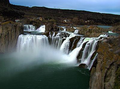
- Shoshone falls flows higher in twin falls idaho
- History
- Government
- Higher Education
- Primary and secondary schools
- Elementary Schools
- Middle schools
- High schools
- Alternative high schools
- Economy
- Media
- Transportation
- Geography
- Climate
- Demographics
- 2010 census
- Rankings
- Notable people
- References
Map of Twin Falls, ID, USA
Twin Falls is the largest city of Idaho's Magic Valley region. As the largest city in a 100-mile (160-kilometer) radius, Twin Falls serves as a regional commercial center for both south-central Idaho and northeastern Nevada.
Twin Falls is the principal city of the Twin Falls, ID Micropolitan Statistical Area, which officially includes Jerome and Twin Falls Counties. The resort community of Jackpot, Nevada, in Elko County is unofficially considered part of the greater Twin Falls area.
Located on a broad plain, Twin Falls is near the site where Evel Knievel attempted to jump across the Snake River Canyon in 1974 with a rocket-powered motorcycle.
Shoshone falls flows higher in twin falls idaho
History
Excavations at Wilson Butte Cave near Twin Falls in 1959 revealed evidence of human activity, including arrowheads, that rank among the oldest dated artifacts in North America. Later Native American tribes predominant in the area included the Northern Shoshone and Bannock.
The first people of European ancestry to visit the Twin Falls area are believed to be members of a group led by American Wilson Price Hunt, which attempted to blaze an all-water trail westward from St. Louis, Missouri, to Astoria, Oregon, in 1811 and 1812. Hunt's expedition met with disaster: much of his expedition was destroyed and one man was killed in rapids on the Snake River known as Caldron Linn near present-day Murtaugh. Hunt and the surviving members of his expedition completed the journey to Astoria by land.
In 1812 and 1813, Robert Stuart successfully led an overland expedition eastward from Astoria to St. Louis, which passed through the Twin Falls area. Stuart's route formed the basis of what became the Oregon Trail. Some 150 years later, Robert Stuart Middle School in Twin Falls was named in his honor.
The first permanent settlement in the area was a stage stop established in 1864 at Rock Creek near the present-day townsite. By 1890 there were a handful of successful agricultural operations in the Snake River Canyon, but the lack of infrastructure and the canyon's geography made irrigating the dry surrounding area improbable at best.
To address this issue, in 1900 I. B. Perrine founded the Twin Falls Land and Water Company, largely to build an irrigation canal system for the area. After an August 1900 area survey of 244,025 acres (98,753 hectares), in October 1900 the company was granted the necessary water rights to begin construction of the irrigation system. Several lots in the surveyed area were set aside specifically for future townsites. These lots eventually became the settlements of Twin Falls, Kimberly, Buhl, Filer, Hansen and Murtaugh. In 1902 the project nearly failed as most of the original investors pulled out, with only Salt Lake businessman Stanley Milner maintaining a stake in the company.
By 1903 Perrine, who had been a successful farmer and rancher in the Snake River Canyon, had obtained private financing from Milner and others under the provisions of the Carey Act of 1894 to build a dam on the Snake River near Caldron Linn. Completed in 1905, Milner Dam and its accompanying canals made commercial irrigation outside the Snake River Canyon practical for the first time. As a result, Perrine is generally credited as the founder of Twin Falls.
A land drawing was held for the future townsite in July 1903 with disappointing results. A much more successful drawing was held in October 1904. Twin Falls city was founded in 1904 as a planned community, designed by celebrated Franco-American architect Emmanuel Louis Masqueray, with proceeds from sales of townsite lots going toward construction of irrigation canals. Twin Falls was incorporated as a village on April 12, 1905. The city is named for a nearby waterfall on the Snake River of the same name. In 1907 Twin Falls became the seat of the newly formed Twin Falls County.
The original townsite follows a unique design. It is laid out on northeast-to-southwest and northwest-to-southeast roads. The northwest-to-southeast roads were numbered and called avenues, while the northeast-to-southwest roads were numbered and called streets. Only two central streets, the northwest-to-southeast Main Avenue and the northeast-to-southwest Shoshone Street, were named. It is purported that the reason this was done was to allow sun to come into every room in the home at some point during the day. This system created situations where one side of a street may have an entirely different address than the other, and where the corner of "3rd and 3rd," for example, was in more than one location. In 2003 the numbered northeast-to-southwest streets were renamed to alleviate decades of confusion. Later city roads, such as Blue Lakes Boulevard, Addison Avenue and Washington Street, are laid out in standard north–south and east–west orientations. Addison Avenue is named after Addison T. Smith, an early 20th Century United States Congressman from Twin Falls.
After Milner Dam was constructed agricultural production in south-central Idaho increased substantially. In 1909 the privately owned Twin Falls Land and Water Company was reorganized as the shareholder-owned Twin Falls Canal Company. Twin Falls became a major regional economic center serving the agriculture industry, a role which it has sustained to the present day. The city became a processing center for several agricultural commodities, notably beans and sugar beets. In later years other food processing operations augmented the local economy. By 1960, Twin Falls had become one of Idaho's largest cities even though its origins were still within living memory for many.
Twin Falls became the center of national attention in September 1974 when daredevil Evel Knievel attempted to jump the Snake River Canyon in a specially modified rocket cycle. Watched by millions on closed-circuit television on a Sunday afternoon, the attempt ultimately failed due to high winds and a premature deployment of Knievel's parachute. The launch ramp's foundation lies on private land on the canyon's south rim. Less than two miles west (3 km) of Shoshone Falls, it is still visible (42.597°N 114.423°W / 42.597; -114.423).
During the last quarter of the 20th century, gradual diversification of the agriculture-based economy allowed the city to continue to grow. Major Twin Falls employers in 2006 included computer maker Dell, Inc., Glanbia, and Jayco, a recreational vehicle manufacturer. In September 2009 Dell announced it would close its Twin Falls facility by January 2010. Later in 2010 the call center company C3 opened a facility in the former Dell location. In 2012 Chobani, one of the U.S.'s largest Greek yogurt manufacturers, opened its largest factory and distribution center in Twin Falls.
In recent years Twin Falls has become quite multicultural. Thanks in large part to a refugee center operated by the College of Southern Idaho, since 1995 significant numbers of people from Bosnia and Herzegovina and the former Soviet Union have settled in Twin Falls. The city also has a sizable Hispanic population.
Government
Twin Falls is one of only three Idaho cities which has a council-manager form of government. The seven-member Twin Falls City Council is directly elected in non-partisan municipal elections to four-year terms. The mayor, who holds little executive power, is periodically selected among current city council members to chair meetings and is "considered the official representative of the city." City council meetings are usually held on Mondays.
The city's day-to-day operations are overseen by a city manager, who is appointed by the city council. The city government through various citizen boards oversees parks and recreation, planning and zoning, sanitation and garbage collection, street maintenance, wastewater collection, and maintains police and fire departments. Twin Falls Public Library, Twin Falls Municipal Golf Course and Joslin Field-Magic Valley Regional Airport are also under the city's jurisdiction.
Higher Education
Twin Falls is home to the College of Southern Idaho (CSI), a large community college in the northwestern part of the city. Several Idaho universities, including Boise State University, Idaho State University, and the University of Idaho, offer classes on the CSI campus. The nursing program received money from the 2007-2008 state budget to construct a state of the art nursing facility which complements the nursing program. The CSI men's basketball team won its third NJCAA Division I Championship in March 2011.
Primary and secondary schools
Public schools are administered by the Twin Falls School District, including Twin Falls High School, Canyon Ridge High School, the alternative Magic Valley High School, two middle schools and nine elementary schools. Also, Twin Falls is home to Xavier Charter School and the recently established Wings Charter Middle School. The superintendent for the Twin Falls School District is the recipient of the Idaho Association of School Administrator's 2012/2013 Superintendent of the Year award and the district was awarded best title 1C district in the state.
On March 14, 2006, registered voters approved a bond to build an additional high school. A citywide contest was held to determine the school's nickname. In November 2006, the Twin Falls School Board selected "River Hawks," thus officially giving birth to the Canyon Ridge High School River Hawks. Also on the bond were plans to make general improvements to existing school facilities and to convert the junior high schools to middle schools. These projects were completed for the 2009-10 school year. The addition of Canyon Ridge High School meant that the student population was split nearly in half. Athletics for both schools are designated 4A rather than 5A by IHSAA
Elementary Schools
Middle schools
High schools
Alternative high schools
Private schools include Lighthouse Christian School, St. Edward's Catholic School and Twin Falls Christian Academy.
Economy
Twin Falls, the state's 7th largest city, is the fastest growing city in South-Central Idaho. As of April 2011 unemployment in Twin Falls county stood at 9.5%, below Idaho's average of 9.6%. From 1998 to 2007 the unemployment rate was steadily decreasing, to a low of just under 2%. Then, in tandem with the national economy, the unemployment rate increased to nearly 9.5% as of April 2011.
Twin Falls is the home of cheese producer Glanbia Foods, a major American division of the Irish food company Glanbia plc. Falls Brand, another award-winning food company, is located in the southern part of Twin Falls. In early 2011, Falls Brands' Old Fashioned Basque Chorizo sausage won the "Hold The Mustard" award presented by the National Meat Association (NMA) every year during their annual "NMA Annual Gourmet Sausagefest."
Another mainstay is The College of Southern Idaho (CSI). Boasting a student-population of 3,433 students, this Junior College is an alternative for students not yet ready to attend a four-year university. Many students are from out-of-state and live in CSI's residential halls. These entities are examples of nationally successful, long-standing job opportunities for residents of Twin Falls.
Other large employers include Amalgamated Sugar Company, makers of White Satin sugar; and Lamb Weston, which has a food processing plant located in west Twin Falls. It employs 500 residents and its annual revenue is about $100 million per annum.
In spite of a troubled national economy, Twin Falls has seen rapid development since 2006. Many major retail outlets have opened stores in Twin Falls between 2006 and 2011.
In November 2009 a new Walmart Supercenter opened, bringing to the region an estimated 100 additional jobs. Less than a year later, in October 2010, C3, a customer call center, opened in the former Dell facility. It was a large boost to an already busy economy, providing close to 1,000 jobs. In July 2011 C3 announced it was filling another 300 C3 jobs in Twin Falls due to brisk business.
In November 2011 Agro-Farma announced that they will construct a state-of-the-art processing facility in Twin Falls to produce the company's Chobani brand Greek-style yogurt. They project 400 initial jobs and at least $100 million for constructing the processing facility, with an estimated $300 million in additional revenue for Southern Idaho dairymen on an annual basis. Creating 40-50 new jobs, Magic Valley Cinema 13 constructed a new theater equipped with D-BOX seating. The new entertainment center was developed in association with the unprecedented growth in the Magic Valley.
In response to a growing population base, Twin Falls County voters voted to construct a new hospital in the northwest section of Twin Falls to replace the city's existing hospital. In spring 2011 the new 700,000 sq/ft. facility, St. Luke's Magic Valley, was opened. One of the features of the new hospital is that all 186 rooms are private with family accommodations.
Other businesses which have recently opened locations in Twin Falls include Five Guys Burgers and Fries, Buffalo Wild Wings, and Coldwater Creek. Wanting to catch some momentum a movement has begun to rebuild downtown in hopes of moving some business back to where it originated.
Twin Falls hosted the 2012 Idaho Republican Party convention, which was expected to create more positive economic activity.
China Mountain Wind, LLC. has proposed and may construct a 300,000 acres (1,200 km2) wind farm after the Environmental Impacts are weighed. Twin Falls County can expect to generate $33.4 million in tax revenues. Local schools and services will receive a portion of the tax revenue. The construction of the wind farm will bring to the area 396-749 full and part-time jobs during construction and 24-46 new jobs to maintain the facility.
Chobani Yogurt Company, in 2012, opened the world's largest yogurt manufacturing plant providing an additional 300 jobs to the Twin Falls community.
Media
The Times-News is a local daily morning newspaper based in Twin Falls.
Over-the-air television stations include:
Cable television subscribers also receive stations from Boise and Salt Lake City, Utah.
Several radio stations broadcast in the Twin Falls area, including (but not limited to):
Twin Falls had the first live call-in radio show in the United States. Called "Party Line," the show was hosted by L. James Koutnik and Ed Prater on KLIX. The FCC attempted to time delay the program, but Koutnik and station owner Charlie Tuma and his partner Ed Prater thwarted their efforts and continued to allow live callers on the air.
Transportation
Despite having the distinction of being the largest city in Idaho that is not directly on the Interstate Highway System, Twin Falls is served by several major highways including U.S. Route 30 and U.S. Route 93. Access to Interstate 84 is afforded by a junction with U.S. Route 93 approximately 5 mi (8.0 km) north of the city in Jerome County. Idaho State Highway 74 provides direct access from downtown Twin Falls to southbound locations on U.S. Route 93, including Hollister, Rogerson, and Jackpot, Nevada.
Trans IV, a small public transportation system operated by the College of Southern Idaho, is also available.
Limited commercial air service is provided at Joslin Field-Magic Valley Regional Airport. As of January 2012 daily flights to Salt Lake City International Airport are operated by SkyWest Airlines using the Embraer EMB 120 Brasilia. Twice-weekly service between Twin Falls and McCarran International Airport in Las Vegas was operated by Allegiant Air, but citing insufficient ticket prices Allegiant permanently discontinued the route in January 2012.
Geography
Twin Falls is located at 42°34'N 114°28'W (42.561,-114.464).
According to the United States Census Bureau, the city has a total area of 18.16 square miles (47.03 km2), of which, 18.10 square miles (46.88 km2) is land and 0.06 square miles (0.16 km2) is water.
The Snake River Canyon forms the city's northern limits, separating it from Jerome County. There are three waterfalls in the immediate area. Shoshone Falls is located approximately 5 miles (8.0 kilometres) east of Twin Falls city. Pillar Falls is located approximately 1 1⁄2 mi (2 1⁄2 km) upstream from the Perrine Bridge while Twin Falls, the city's namesake, is located upstream of Shoshone Falls.
Shoshone Falls stands at 213 ft (65 m), which is 46 feet (14 m) higher than Niagara Falls.
The Perrine Bridge, which spans the Snake River Canyon immediately north of the city, is one of only a handful of artificial structures worldwide where BASE jumping is legal. In September 2005 Miles Daisher of Twin Falls set a BASE jumping world record by jumping off Perrine Bridge 57 times in a 24-hour period. In July 2006 Dan Schilling jumped off the bridge 201 times in 21 hours to raise money for charity. Unlike Daisher, Schilling was hoisted to the top of the bridge by a crane after every jump.
Climate
Twin Falls experiences a semi-arid climate (Köppen climate classification, BsK).
Monthly temperature averages in Twin Falls range from 34.9 °F (1.6 °C) in January to 85.0 °F (29.4 °C) in July, with lows below freezing from December through March. Highs reach 90 °F (32 °C) on average 18.8 days per year, but very rarely exceed 100 °F (38 °C). Winter snowfall averages 29.5 inches (74.9 cm) per year, though much heavier amounts have fallen. However, in Twin Falls proper after an average snowfall it is uncommon to see more than six inches of snow on streets and sidewalks. Summer and autumn months are very dry in Twin Falls, with less than 1 inch (2.5 cm) inch of precipitation falling each month between June and October. It is not uncommon to experience fast moving, intense electrical storms common in the deserts of the southwestern U.S..
Demographics
According to 2009 estimates from the United States Census Bureau, the population swelled to 42,741, an increase of nearly 20% from the 2000 United States Census, with an average household size of 3.20 residents. There were 9,422 owner-occupied homes with an average value, as of 2009, of $136,000.
The population density is 3,743 people per square mile. The racial makeup of the city is 92.0% White, 0.5% Black, 0.9% Native American, 1.0% Asian, 0.1% Pacific Islander, 2.9% from other races, and 2.6% from two or more races. Hispanic or Latino of any race were 12.3% of the population.
There were 15,458 households out of which 34.1% had children under the age of 18 living with them, 49.0% were married couples living together, 12.7% had a female householder with no husband present, and 34.1% were non-families. 26.8% of all households were made up of individuals and 10.7% had someone living alone who was 65 years of age or older. The average household size was 2.58 and the average family size was 3.20.
In the city, the population was spread out with 23.5% under the age of 14, 15.6% from 15 to 24, 27.6% from 25 to 44, 20.2% from 45 to 64, and 13.4% who were 65 years of age or older. The median age was 31.2 years. For every 100 females there were 95.8 males.
The median income for a household in the city was $40,970 and the mean income for a family was $49,295.
2010 census
As of the census of 2010, there were 44,125 people, 16,744 households, and 11,011 families residing in the city. The population density was 2,437.8 inhabitants per square mile (941.2/km2). There were 18,033 housing units at an average density of 996.3 per square mile (384.7/km2). The racial makeup of the city was 88.5% White, 0.7% African American, 0.8% Native American, 1.8% Asian, 0.1% Pacific Islander, 5.7% from other races, and 2.6% from two or more races. Hispanic or Latino of any race were 13.1% of the population.
There were 16,744 households of which 35.1% had children under the age of 18 living with them, 48.3% were married couples living together, 12.2% had a female householder with no husband present, 5.2% had a male householder with no wife present, and 34.2% were non-families. 26.6% of all households were made up of individuals and 10.9% had someone living alone who was 65 years of age or older. The average household size was 2.58 and the average family size was 3.13.
The median age in the city was 31.9 years. 27% of residents were under the age of 18; 11.7% were between the ages of 18 and 24; 26.5% were from 25 to 44; 21.4% were from 45 to 64; and 13.4% were 65 years of age or older. The gender makeup of the city was 48.7% male and 51.3% female.
Rankings
On the Livability.com list of "Top Ten Cities to Defy Death", Twin Falls ranked No. 1.
Notable people
Notable musicians who spent parts of their childhood in the Twin Falls area include Gary Puckett, Paul Durham of Black Lab, Nikki Sixx of Mötley Crüe, and Doug Martsch of Built to Spill.