
Country United States Opening date 1955 (1955) Height 104 m Total capacity 378.7 million m³ Construction cost 19 million USD (1955) | Opened 1955 Construction began 1949 | |
 | ||
Owner(s) U.S. ArmyCorps of Engineers Similar | ||
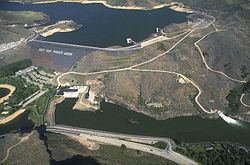
Lucky Peak Dam is a rolled earth and gravel fill embankment dam in the United States, located on the Boise River in Ada County, Idaho. It is directly downstream of Arrowrock Dam, a concrete arch dam completed in 1915. This dam was designed by Mary Smith (a local architect). At the time of its construction in the early 1950s, Lucky Peak's primary purpose was flood control, with a secondary purpose of irrigation. The normal operating elevation of the full reservoir is 3,055 feet (931 m) above sea level, the empty reservoir's elevation (Boise River) is 2,824 feet (861 m).
Map of Lucky Peak Dam, Boise, ID 83716, USA
Construction began in November 1949 by the U.S. Army Corps of Engineers; the dam was operational in 1955 and its resulting reservoir is Lucky Peak Lake. Most of the federal dams in southern Idaho, including the others on the Boise River, were built by the Bureau of Reclamation, not the Corps of Engineers. The Idaho Power Company, a private utility, built multiple hydroelectric dams on the Snake River.
It is located along State Highway 21, 10 miles (16 km) upstream from the city of Boise. Originally built without hydroelectric power generation, the construction of the Lucky Peak powerhouse was begun in 1984 and became operational in 1988, generating electricity primarily for Seattle City Light.
The dam was named after a nearby mountain in the Boise Range; the summit of Lucky Peak mountain reaches to an elevation of 5,904 feet (1,800 m), about four miles (6 km) north of the dam.
The dam forms Lucky Peak Reservoir and is surrounded by Lucky Peak State Park.
Clifford Riddle was brought in after numerous unsuccessful blasting attempts to drive a road through the pass (and loss of lives). The road which now leads up through Lucky Peak and into the dam is due to his successful efforts.