
Population 2,230 (2006 Census) Mayor Bernard Singer Area 102,650 km² | Established 1981 Founded 1981 | |
 | ||
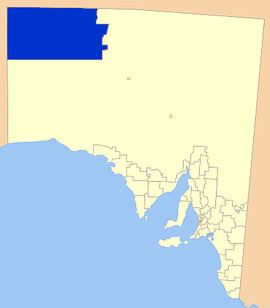
Website Anangu Pitjantjatjara Yankunytjatjara Anangu Pitjantjatjara Yankunytjatjara Unincorporated area of South Australia | ||
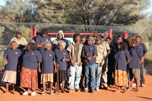
Aṉangu Pitjantjatjara Yankunytjatjara (APY) is a large Aboriginal local government area located in the remote north west of South Australia. It consists of the Pitjantjatjara, Yankunytjatjara and Ngaanyatjarra aṉangu (i.e. people), and has a population of around 2500 people.
Contents
- History
- Recent developments
- Function
- Population
- Localities
- Public transport
- Communications
- Adjoining LGAs
- References
"This Inquiry has uncovered a sad stream of stories from the Lands. I have heard that sexual abuse of children on the Lands has been widespread throughout the communities for many years..."

History
The Pitjantjatjara and Yankunytjatjara people (aṉangu) had lived in this area for many thousands of years.
After the British began to colonise the Australian continent from 1788 onwards, the aṉangu remained more or less undisturbed for many more years, apart from very occasional encounters with a variety of European explorers.
In 1921, with white settlement now beginning to encroach on the aṉangu's traditional land, the South Australian Government proclaimed the North-West Aboriginal Reserve. This Reserve consisted of most is what is now known as the APY Lands, with the exception of the eastern part of the APY Lands, which was given over to pastoral leases to Europeans.

In 1937, the Presbyterian Church established the Ernabella Mission on the Lands at the place that is now known as the community of Pukatja.
By the 1950s, many aṉangu were living at the Ernabella Mission, while many others lived at camps on pastoral leases on what are now the Lands, or nearby, where they would work. Those pastoral leases included Granite Downs, Everard Park, Victory Downs, De Rose Hill, Kenmore Park, and Mount Cavanagh.
In 1961, to prevent overcrowding at Ernabella Mission, the Church established what became the community of Amata, but which was originally known as Musgrave Park. At the same time the Church also established what is now the community of Kaltjiti, but which was then known as Fregon.
In 1968, what is now the community of Indulkana was established by the South Australian Government, as a base from which to provide welfare services to aṉangu living in camps on pastoral leases, where work was becoming increasingly difficult to find. At that time, the surrounding area was excised from pastoral leases and declared the Indulkana Aboriginal Reserve.
The body now known as Aṉangu Pitjantjatjara Yankunytjatjara was formed in 1981 by the passing of the Anangu Pitjantjatjara Yankunytjatjara Land Rights Act, 1981 by the Parliament of South Australia, and includes the Pitjantjatjara, Yankunytjatjara and Ngaanyatjarra groups.
'Ara Irititja' is a project of the APY, commenced in 1994 to identify, copy and electronically record historical materials about the Anangu (Pitjantjatjara/Yankunytjatjara people). Its purpose is to prevent the loss of the history, and to allow the teaching of it to others in the community.
The peoples of the region have not had any major economic development, apart from tourism, but there have been proposals to mine in the area. The Mintabie opal fields are located in the area but separate.
The Musgrave Block in the Pitjantjatjara Lands, in South Australia's far north-west, has been viewed as having billions of dollars in potential mineral deposits and petroleum. But the Yankunytjatjara Pitjantjatjara people have been wary of opening up the area to mining, concerned about the impact on sacred sites and the environment. Mining companies are conducting discussion to try to allay these worries.
For decades two major issues throughout the APY Lands have been the low standard of health care (compared to the rest of Australia) and drug abuse, namely alcohol, petrol sniffing, cannabis and later other illicit drugs. Part of the difficulty in reducing alcohol and illicit drug use has been the straddling of the indigenous area by three jurisdictions: South Australia, Western Australia and the Northern Territory. The jurisdictional crossover has made police enforcement of drug trafficking laws difficult, but in 2007 collaboration between these states was reported to be delivering results.
Recent developments
"This Inquiry has uncovered a sad stream of stories from the Lands. I have heard that sexual abuse of children on the Lands has been widespread throughout the communities for many years..."
Function
The statutory functions of the APY are:
(a) to ascertain the wishes and opinions of traditional owners in relation to the management, use and control of the lands and to seek, where practicable, to give effect to those wishes and opinions;(b) to protect the interests of traditional owners in relation to the management, use and control of the lands; and(c) to negotiate with persons desiring to use, occupy or gain access to any part of the lands;(d) to administer land vested in Aṉangu Pitjantjatjara Yankunytjatjara.Population
The 2006 ABS identified that the APY Lands had 2,230 residents, 50.6% of whom were female and 84.5% of whom were Indigenous Australians (compared to a national percentage of 2.3%).
The APY Lands communities had a significantly higher proportion of younger people than the overall Australian population, and accordingly significantly lower proportion of older people than the overall population.
98% of the residents were Australian-born (compared to 86.1% nationwide).
58.6% of residents listed Pitjantjatjara as the language spoken at home, whilst 14.3% listed Yankunytjatjara as their spoken language. 18.7% gave English as the language spoken at home, compared with 78.5% of the overall Australian population.
46.1% identified with being affiliated with the Uniting Church in Australia (compared to 5.7% with that affiliation nationwide), explainable by the UCA's significant presence in each community.
Median incomes in the APY Lands were significantly lower than the Australian population, with a median individual weekly income of $219/week compared with $466/week nationwide.
The APY Lands have a significantly larger proportion of single-parent families (30.1% cf 15.8% nationwide).
Home ownership is a distant reality for most people on the APY Lands, with only 7% of residents either fully owning or in the process of purchasing their own home - compared with 32.6% of Australians fully owning and 32.2% purchasing (a nett of 64.8%). The majority of APY Lands residents are likely to have a landlord.
The largest towns in the area are (with 2011 census population figures):
Localities
The local government area encompasses a number of settlements of a range of sizes, many of them being located in the Musgrave Ranges. The full list is:
The Aṉangu Lands Paper Tracker website operated by Uniting Care Wesley Adelaide provides an interactive map of the communities (see Links section below).
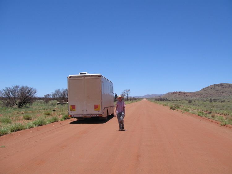
Public transport
The UnitingCare Wesley Adelaide project, "Paper Tracker" describes that as from October 2007 a bus service will operate through the lands connecting via Marla to Alice Springs:
In 2004, the South Australian Government allocated funding for a public transport bus service on the APY Lands. From October 2007, a twice-weekly return service will run from Alice Springs to Marla via main communities on the eastern-side of the APY Lands.
Communications
Even in this remote area, houses have telephones, access to multiple television channels including (Imparja and ABC), and mail is delivered weekly by air from Alice Springs. Many of the localities described above are slated for broadband delivery in the near future.
Adjoining LGAs
In 2008, the Northern Territory proposes under its local government reforms to create the MacDonnell Shire which will span the south of the Territory from western to eastern border, thereby comprising the adjoining LGA across the top of the APY Lands.
The Outback Communities Authority in South Australia is not an LGA, but is the authority responsible for the development of areas adjoining the APY Lands (not including Maralinga Tjarutja to the south and the District Council of Coober Pedy to the non-immediate, but relatively nearby, south-east).