
Nationality American Spouse Ellen Powell Thompson | Name Almon Thompson Died 1906 | |
 | ||
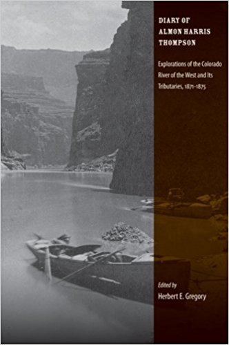
Books The Diary of Almon Harris Thompson: Explorations of the Colorado River of the West and Its Tributaries, 1871-1875 | ||
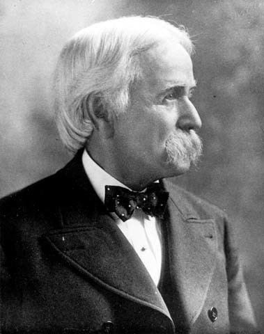
Almon Harris Thompson (September 24, 1839 – July 31, 1906), also known as "A. H. Thompson", was an educator, topographer, geologist, explorer, and Civil War veteran. Often called "The Professor" or simply "Prof", Thompson was second in command of John Wesley Powell's Second Expedition, a federally funded expedition to explore the Green and Colorado Rivers, Colorado drainage and canyons, and map southern Utah and northern Arizona. Thompson's diary of Powell's Second Expedition (1871–1875) was originally published in the Utah Historical Quarterly in 1939. Through his work on the Powell expeditions and later as geographer at the US Geological Survey, he was responsible for naming many geographic locations in the west. Thompson is also known for his involvement in the formation of the National Geographic Society.
Contents
- Early life and education
- Expeditions
- After the Powell Expeditions
- National Geographic Society
- Later years
- Naming of geographic locations
- Legacy
- References
Early life and education
Thompson was born on September 24, 1839 in Stoddard, New Hampshire. Later, his family moved to Southborough, Worcester, Massachusetts (1848–1856) where he attended school. Thompson enjoyed mathematics and science. Thompson attended Wheaton College (1857–1861) in Illinois where he met John Wesley Powell. After graduation, he married Ellen Louella (Nellie) Powell (1840–1909), the sister of John Wesley Powell on July 8, 1862 in Wheaton, Illinois. They had no children.
On May 16, 1864, Almon H. Thompson enlisted in the United States Army noting his residence as Hennepin, Illinois. He was commissioned as a lieutenant in Company B, 139th Illinois Volunteer Infantry Regiment on June 1, 1864. Thompson was part of the Hundred Days Men enlistment program near the end of the Civil War. He mustered out in Peoria, Illinois on October 28, 1864 as a 1st Lieutenant.
After the war, Thompson served as superintendent of schools at Lacon, Illinois (1865–1867) and Bloomington, Illinois (1867–1868). In the 1870 census, Thompson is listed as living in Normal, Illinois with his wife Ellen, mother Mary, as well as Emma and John Powell. Both Thompson and Powell are listed as school teachers.
Expeditions
In 1867, Thompson's brother-in-law, John Wesley Powell, put together an expedition to the Rocky Mountains to collect specimens for the Illinois State Natural History Society. Thompson acted as the entomologist of the party. After the expedition, in 1868, Thompson resumed the superintendency of the Bloomington, Illinois schools. He was appointed acting curator of the Illinois Natural History Society in 1869.
In 1870, Powell and Thompson began plans for what is known as Powell's Second Expedition, exploring the Colorado River and surrounding plateau country. They secured supplies at Fort Bridger and Salt Lake City to be shipped to three locations along the expedition route. The group set out from Green River, Wyoming in May 1871 with the geographical work in Thompson's hands. He served as chief topographer and geographer, and was in charge of field operations when Powell was absent. Because Powell was often away from the work site, Thompson was often in charge. The explorers mapped much of Utah and northern Arizona while on a boat journey from Green River, Utah to Lees Ferry.
In addition to the river survey, Thompson also led a significant overland expedition. Along with other members of the Survey, he left Kanab, Utah on May 30, 1872 to identify a passage to the mouth of the Dirty Devil River where the Second Expedition crew had stored a boat. Their route led them along the Paria River, in the southern end of the Aquarius Plateau, over Boulder Mountain, through the Waterpocket Fold, and across the Henry Mountains. After finding the boat, Thompson mapped a return route overland while other members of the group took the boat downstream. In Chapter X: Report on a Trip to the Mouth of the Dirty Devil River in the Exploration of the Colorado River of the West, Thompson describes his experiences. During this trip, he named the Escalante River, the last river of the contiguous United States to be identified. He was also the first Euro-American to reach the summit of the Henry Mountains. He named it Mount Ellen after his wife.
Powell gave Thompson credit for his work in the Preface of one of their reports stating, "Professor A. H. Thompson has been my companion and collaborator during the greater part of the time, and has had entire charge of the geographic work; the final maps will exhibit the results of this learning and executive ability".
Ellen Powell Thompson accompanied her husband on some of the activities including trips into the mountains and boating the rapids of southern Utah. While residing in Kanab, Utah in 1872, she collected and identified many new types of plants.
Under Thompson's direction, the team created the first preliminary map of the southern Utah region in the winter of 1872–73. Ultimately, Thompson constructed maps of Utah, Wyoming, Arizona, and Nevada based on field-work from the Powell expeditions. After the expedition, both Thompson and his wife returned to Aurora, Illinois. They were both listed as members of the Illinois State Association for Schoolmasters in 1873–1874.
In 1875, Thompson, along with Frederick Dellenbaugh, returned to Utah focusing on field studies and mapping of the land. At the completion of their expedition assignments in 1878, Thompson began to look for work. The April 25, 1878 Winfield (KS) Courier reported that Thompson was exploring locations to start a sheep business in Kansas. The 1880 census lists Thompson is as living in Salem, Greenwood, Kansas and working as a wool grower.
After the Powell Expeditions
In the early 1880s, Thompson began work for the U.S. Geological Survey under the new USGS director, John Wesley Powell. He and Ellen moved to Washington, D.C. Thompson was sent to New Mexico to begin topographical surveying. The Sundry Civil Bill of 1888 appropriated funding for an irrigation survey. Thompson directed work parties throughout the west.
Later, Thompson was appointed the chief geographer for the USGS. As a geographer and cartographer, he authored or co-authored many maps for the USGS including the Green River from Union Pacific Railroad to the Mouth of the White River. Thompson was involved in a number of projects including serving as cartographer on projects in California, Colorado, Nevada, Idaho, Oregon and Wyoming.
Thompson also devised a survey instrument used during geographical operations to provide measurements that could be used in determining the irrigable land. He contributed chapter IX to the Report on the Lands of the Arid Region, by John Powell. The chapter, titled "Irrigable Lands of the Portion of Utah Drained by the Colorado River and its Tributaries", focuses on river drainage, tributaries, and geography.
National Geographic Society
Thompson was part of a tight knit community of explorers, scientists, and businessmen in Washington, D.C. interested in forming a geographic society. He was one of several signatories on an invitation to meet on January 13, 1888. Thompson called the meeting to order and introduced the resolution to form the society. Within two weeks, an organizing committee consisting of Thompson and others created the plan for the National Geographic Society. Thompson was a founding member of this society. Serving as one of the vice-presidents of this new organization, Thompson was actively involved in its growth.
Later years
In a report submitted July 1, 1893, Thompson described work conducted in all of the western states and the establishment of new field offices in California, Idaho, Oregon, and Washington.
Thompson retained this post at the USGS until his death on July 31, 1906. He was buried at Arlington National Cemetery in the Officers Section, Site 1567 in August 1906.
Naming of geographic locations
Thompson is credited with naming many geographic locations in his work with John Wesley Powell and the USGS. He named the Waterpocket Fold in what is now Capital Reef National Park, the Aquarius Plateau, and Boulder Mountain in southern Utah, Canaan Mountain, Markagunt Plateau, Escalante River, and the town of Escalante in Garfield County, Utah. He named Mount Ellen in the Henry Mountains after his wife.
Thompson had strong opinions about the need for principles to aid in geographic nomenclature. He stated that "a geographic name should be short, euphonic, pronounced as spelled, and have a meaning or express some sentiment to help fix it in the memory".
In choosing geographic names during the Powell expeditions, Thompson selected a combination of Piute terms such as Kaibab and Toroweap, Mormon pioneer words like Pipe Springs and Wild Band Pockets, and also used descriptive words like Tantalus Creek and Thousand Lakes Mountain.
Thompson Mesa in the Henry Mountains, Thompson Point in the Grand Canyon Mount Thompson in the Sierra Nevada Mountains, and Thompson Peak in the Sangre de Cristo Mountains near Santa Fe were all named in honor of A. H. Thompson.
Legacy
Thompson's accomplishments are often overlooked in history books and websites. Dellenbaugh notes that although Thompson was largely responsible for the "scientific and practical success of the second expedition", Powell ignored Thompson's contributions in his reports.
In the introduction to Thompson's diaries, Herbert Gregory states that "Thompson possessed that rare combination of qualities that brings success to the explorer: a rigid insistence on discipline and order of procedure, kindness toward his subordinates, and sympathetic interest in the native people with whom he came in contact".
Frederick Dellenbaugh, author of The Romance of the Colorado River and member of the expedition, stated that "to his (Thompson's) foresight, rare good judgment, ability to think out a plan to the last minute detail, fine nerve and absolute lack of any kind of foolishness, together with a wide knowledge and intelligence, this expedition, and indeed the scientific work so admirably carried on by the United States Survey of the Rocky Mountain region and the Geological Survey for three decades in the Far West, largely own success".