
- left Muddy Creek - elevation 4,266 ft (1,300 m) - average 101 cu ft/s (3 m/s) Source Wasatch Range | - right Fremont River - elevation 3,703 ft (1,129 m) Length 129 km Cities Salt Lake City | |
 | ||
- location | ||
The Dirty Devil River is an 80-mile-long (130 km) tributary of the Colorado River, located in the U.S. state of Utah. It flows through southern Utah from the confluence of Fremont River and Muddy Creek to the Colorado River.
Contents
Map of Dirty Devil River, Utah, USA
CourseEdit
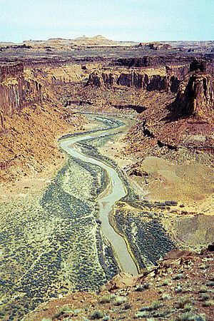
The Dirty Devil River is formed in Wayne County near Hanksville at the confluence of the Fremont River and Muddy Creek. It flows generally south through a 2,000 feet (610 m) deep canyon in Wayne and Garfield counties. Its lower 20 miles (32 km) flows through Glen Canyon National Recreation Area. It disembogues into Lake Powell on the Colorado.
The canyon of the river is particularly isolated and is seldom visited compared to other natural areas in the region. The average discharge is approximately 446 cfs.
HistoryEdit
The Dirty Devil River was named during the 1869 Colorado River expedition led by John Wesley Powell.
The outlaw Butch Cassidy used tributary canyons of the Dirty Devil, such as Robbers Roost, as a hideout in the 1890s.
GeologyEdit
The Dirty Devil River and its tributaries contribute approximately 150,000 tons of salt to the Colorado River each year, with the Muddy Creek tributary contributing an annual average of 86,000 tons by itself. The Fremont River tributary does not contribute significant amounts of salt. The United States Bureau of Reclamation has created a plan to reduce the salinity of the Dirty Devil River by collecting salty spring water and using deep-well injection to dispose of it. The plan, completed in 1987, has not been implemented due to its marginal cost effectiveness.
BridgesEdit
The river is spanned by a steel arch bridge on State Route 95 near milepost 45 in Garfield County.