
Country Indian Language spoken Area 83,743 km2 | Region Capital Founded 20 February 1987 Chief Minister Nabam TukiINC Governor Nirbhay Sharma Literacy 66.95% Population 1.255 million (2012) | |
 | ||
Destinations Colleges and Universities Arunachal University of Studies, Rajiv Gandhi University (Itanagar), Himalayan University | ||
Arunachal Pradesh is one of the 29 states of India. Located in northeast India, it holds the most north-eastern position among the other states in the north-east region of India. Arunachal Pradesh borders the states of Assam and Nagaland to the south, and shares international borders with Bhutan in the west, Myanmar in the east and China in the north. Itanagar is the capital of the state. China claims the northern part of the state as a part of the Tibet Autonomous Region.
Contents
- Map of Arunachal Pradesh
- Tourist attractions in arunachal pradesh
- Arunachal pradesh beautiful places to visit
- History
- Geography
- Economy
- Tourism
- Cuisine of Arunachal Pradesh
- Food of arunachal pradesh tribal fare from northeast india
- Arunachali woman preparing food
- References
Map of Arunachal Pradesh
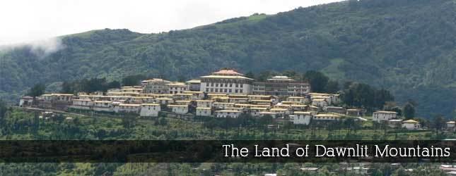
Arunachal Pradesh, which translates to "land of the dawn-lit mountains", is also known as the Orchid State of India or the Paradise of the Botanists. Geographically, it is the largest among the North-east Indian states commonly known as the Seven Sister States. As in other parts of Northeast India, the people native to the state trace their origins from the Tibeto-Burman people. In recent times, large number of migrants from various parts of India and foreign lands have been affecting the states population.
Tourist attractions in arunachal pradesh
No reliable population count of the migrant population exists, and the percentage estimating the total actual population accordingly vary. Arunachal Pradesh has the highest number of regional languages in South Asia enriched with diverse culture and traditions.
Arunachal pradesh beautiful places to visit
History
The history of pre-modern Arunachal Pradesh remains shrouded in mystery. Oral histories possessed to this day by many Arunachali tribes of Tibeto-Burman stock are much richer and point unambiguously to a northern origin in modern-day Tibet. Again corroboration remains difficult. From the point of view of material culture it is clear that most indigenous Arunachali groups align with Burma-area hill tribals, a fact that could either be explainable in terms of a northern Burmese origin or from westward cultural diffusion.
From the same perspective the most unusual Arunachali group by far is the Puroik/Sulung, whose traditional staple food is called "tasey" or "taase" made from sago palm and whose primary traditional productive strategy is foraging. While speculatively considered a Tibeto-Burman population, the uniqueness of Puroik culture and language may well represent a tenuous reflection of a distant and all but unknown pre-Tibeto-Burman, Tai and Indo-Aryan past.
According to the Arunachal Pradesh government, the Hindu texts Kalika Purana and Mahabharata mention the region as the Prabhu Mountains of the Puranas, and where sage Parashuram washed away sins, the sage Vyasa meditated, King Bhishmaka founded his kingdom, and Lord Krishna married his consort Rukmini.
Recorded history from an outside perspective only became available in the Ahom and Sutiya chronicles. The Monpa and Sherdukpen do keep historical records of the existence of local chiefdoms in the northwest as well. Northwestern parts of this area came under the control of the Monpa kingdom of Monyul, which flourished between 500 B.C. and 600 A.D. This region then came under the loose control of Tibet and Bhutan, especially in the Northern areas. The remaining parts of the state, especially those bordering Myanmar, were under the control of the Sutiya Kings until the Ahom-Sutiya battle in the 16th century. The Ahoms held the areas until the annexation of India by the British in 1858. However, most Arunachali tribes remained in practice largely autonomous up until Indian independence and the formalisation of indigenous administration in 1947.
Recent excavations of ruins of Hindu temples such as the 14th century Malinithan at the foot of the Siang hills in West Siang were build during the Sutiya reign. Another notable heritage site, Bhismaknagar, has led to suggestions that the Idu (Mishmi) had an advanced culture and administration in pre-historical times. Again, however, no evidence directly associates Bhismaknagar with this or any other known culture but the Sutiya rulers held the areas around Bhismaknagar from the 12th to 16th century. The third heritage site, the 400-year-old Tawang Monastery in the extreme north-west of the state, provides some historical evidence of the Buddhist tribal people. The sixth Dalai Lama Tsangyang Gyatso was born in Tawang. Major tribe of Arunachal Pradesh Nyishi,Apatani, Galo, Adi, Monpa, Mishmi, Shingpo, Khamti, Serdukpen,
Geography
Arunachal Pradesh is located between 26.28° N and 29.30° N latitude and 91.20° E and 97.30° E longitude and has 83,743 square kilometre area.
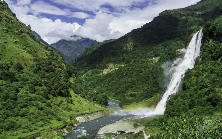
Most of Arunachal Pradesh is covered by the Himalayas. However, parts of Lohit, Changlang and Tirap are covered by the Patkai hills. Kangto, Nyegi Kangsang, the main Gorichen peak and the Eastern Gorichen peak are some of the highest peaks in this region of the Himalayas. The land is mostly mountainous with the Himalayan ranges running north south. These divide the state into five river valleys: the Kameng, the Subansiri, the Siang, the Lohit and the Tirap. All these are fed by snow from the Himalayas and countless rivers and rivulets. The mightiest of these rivers is Siang, called the Tsangpa in Tibet, which becomes the Brahmaputra after it is joined by the Dibang and the Lohit in the plains of Assam.
At the lowest elevations, essentially at Arunachal Pradeshs border with Assam, are Brahmaputra Valley semi-evergreen forests. Much of the state, including the Himalayan foothills and the Patkai hills, are home to Eastern Himalayan broadleaf forests. Toward the northern border with Tibet, with increasing elevation, come a mixture of Eastern and Northeastern Himalayan subalpine conifer forests followed by Eastern Himalayan alpine shrub and meadows and ultimately rock and ice on the highest peaks.
The Himalayan ranges that extend up to the eastern Arunachal separate it from Tibet. The ranges extend toward Nagaland, and form a boundary between India and Burma in Changlang and Tirap district, acting as a natural barrier called Patkai Bum Hills. They are low mountains compared to the Greater Himalayas.
Economy
The chart below displays the trend of the gross state domestic product of Arunachal Pradesh at market prices estimated by the Ministry of Statistics and Programme Implementation with figures in billions of Indian Rupees. See also List of Indian states by GDP.
Tourism
The state, on account of its unrivalled aesthetics and diverse cultural heritage possesses a great tourism potential. Popular tourist attractions include Tawang (a town with a Buddhist monastery) at 3000 m elevation, Ziro (which holds cultural festivals),Basar, the Namdapha tiger project in Changlang district and Sela lake near Bomdila with its bamboo bridges overhanging the river. Religious places of interest include Malinithan in Lekhabali, Rukhmininagar near Roing (the place as per the popular Hindu mythology, Rukmini, Lord Krishnas wife, said to have lived), and Parshuram Kund in Lohit district as Puranas is the lake where sage Parshuram washed away his sins, The Ganga lake(Gyaker sinyi or Gekar Sinyi)and various other tourist hot spots.
The state provides abundant scope for angling, boating, rafting, trekking and hiking. Rafting and trekking are common activities. Some suggested routes for travel or trekking are
Over the years, the Jawaharlal Nehru Museum, Itanagar has become an important tourist destination in the state capital.
The state is rich in wildlife and has a number of wildlife sanctuaries and national parks with rare animals, birds and plants. Perhaps the highest diversity of mammals in India is in Arunachal Pradesh (200+ species). The diversity of birds is also very high, 700+ and is second only to Assam.
Cuisine of Arunachal Pradesh
The dishes typical of the Indian state of Arunachal Pradesh vary within the region, including according to tribal influence (with the influence of Apatanis, Chuki, and Nishi
Food of arunachal pradesh tribal fare from northeast india
Apang or rice beer made from fermented rice or millet is a popular beverage in Arunachal Pradesh, as an alcoholic drink. There are different varieties of rice beer with different flavours. Thukpa is another traditional dish common among "Monpa" a tribe of Arunachal.
Arunachali woman preparing food
The staple food is rice along with fish, meat and many green vegetables. Different varieties of rice are available. Lettuce is the most common and preferred vegetable of all, prepared by boiling it with ginger, coriander and green chillies. Boiled rice cakes wrapped in leaves is a famous snack.
The momos are also popular. Dishes in eastern districts like Tirap and Changlang have some different method in their way of food preparation.