
District West Kameng Elevation 2,217 m | Time zone IST (UTC+5:30) Vehicle registration AR Population 6,685 (2001) | |
 | ||
Weather 6°C, Wind W at 5 km/h, 75% Humidity | ||
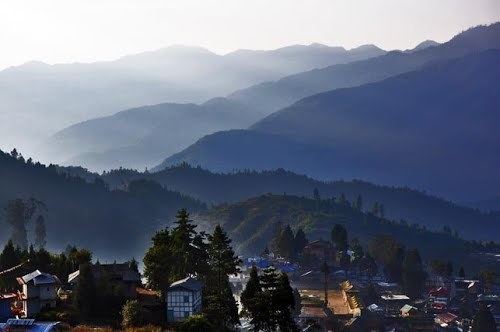
Bomdila sightseeing places to visit in bomdila arunachal pradesh travel guide
Bomdila is the headquarters of West Kameng district in the state of Arunachal Pradesh in India. Bomdile is one of the 60 constituencies of the state of Arunachal Pradesh. The MLA for this region (in August 2016) is Japu Deru.
Contents
- Bomdila sightseeing places to visit in bomdila arunachal pradesh travel guide
- Map of Bomdila 790001
- Streets of the marketplace in bomdila arunachal pradesh
- Geography
- Demographics
- Features
- Media
- References
Map of Bomdila 790001
Streets of the marketplace in bomdila arunachal pradesh
Geography
Bomdila is located at 27.25°N 92.4°E / 27.25; 92.4. It has an average elevation of 2217 metres (7273 feet).
Demographics
As of 2001 India census, Bomdila had a population of 6685. Males constitute 54% of the population and females 46%. Bomdila has an average literacy rate of 69%, higher than the national average of 59.5%; with male literacy of 75% and female literacy of 63%. 13% of the population is under 6 years of age. It is inhabited by the Monpa, Sherdukpen, Miji, Bugun (Khowa) and Aka tribes.
Features
The Eaglenest Wildlife Sanctuary is near Bomdila. Tourism is new to Bomdila because of lack of infrastructure of roads in Northeast India. There are hotels Much of the food here is Tibetan. The Bomdila pass offers views of Kangto and Gorichen Peaks, the highest in the state. Visit GRL Tibetan Buddhist Monastery. Visit apple orchards and orchid farms.
Media
Bomdila has an All India Radio Relay station known as Akashvani Bomdila. It broadcasts on FM frequencies.