
Language spoken District Lower Subansiri | State | |
 | ||
Map of Ziro
Ziro is the census town in Lower Subansiri district in the Indian state of Arunachal Pradesh. It has been a favourite town for World Heritage Site for a number of years now. In a meeting of Archaeological Survey of India (ASI) on 12 December 2012 it was shortlisted for inclusion in the Tentative List for further nomination to UNESCO for inscription in the World Heritage Site. The part of the town which is the centre of economic activities and where the administrative offices are located is called as Hapoli or locally known by the Apatanis as "Hao-Polyang".
Contents
- Map of Ziro
- One fine evening at hapoli town at the ziro valley
- Ziro arunachal pradesh
- Geography
- Climate
- Demographics
- Education
- References
Ziro is around 115 km from the state capital Itanagar and takes approx 3 and a half hours via the improved Hoj-Potin road along NH229 and 150 km via the Assam route. Earlier the nearest railway station from Ziro was located at North Lakhimpur in Assam near the Arunachal-Assam border which is around 100 km from Ziro.
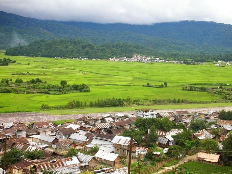
One fine evening at hapoli town at the ziro valley
Ziro arunachal pradesh
Geography
27°33′59″N 93°49′53″E
Ziro is the district headquarters of Subansiri district and is one of the oldest towns in Arunachal Pradesh. It was the headquarters of the undivided Subansiri district comprising the present districts of Upper Subsansiri, Kurung Kumey, Lower Subansiri and Papum Pare. It is located at 27.63°N 93.83°E / 27.63; 93.83 at an elevation of 1688 metres (5538 feet) to 2438 meters (8000 feet). Its cool weather in summer is its major attraction. It is famous for its pine-clad gentle hills around it and rice field all around. Ziro is home to the Apatani tribe.
Apatanis have few unique special characteristic features which differs from other tribes in Arunachal Pradesh and India. Few of these special characteristic features are: (A) Apatanis are permanently settled in one place whereas other tribes are nomadic in nature move from one place to another in search of fertile lands. They travel vast area of forests and settle temporarily for not more than four to five years in one place. (B) Apatanis cultivate permanent wet land cultivations whereas other tribes practice dry land cultivations by clearing the forests by burning the jungles. (C) Apatanis used to practice facial tattoos before; now they have dropped this custom few decades back.
Ziro is included as in India's Tentative List for UNESCO's World Heritage Site.
Climate
The climatic condition of the district varies from place to place as well as season to season. The climate is largely influenced by the nature of terrain depending upon altitude and location of place. It may broadly be divided into four seasons in a year:
- The cold weather season is from December to February
- March to May is the pre-monsoon season of thunderstorms
- The south–west monsoon from June to about the middle of October
- The second half of October to November, which constitutes the post-monsoon or the retreating monsoon period and is a period of transition
In the foothills or low high belt area of the district, the climatic condition is moderate in comparison to high belt areas, where during winter it is very cold and chilly, and in summer is pleasant. December and January are generally the coldest month, and July and August are warmest months.
Annual rainfall in the south is heavier than that in the northern areas of the district. During the monsoon period more than 70 percent of the rain over the southern half occurs while in the northern portions it is about 60 percent. Variability of rain fall for the monsoon and the year, as a whole, are relatively small. Average annual rainfall of the district headquarters, Ziro recorded as 934.88 cm during 2000.
Relative humidity is always high throughout the year except in the winter months being slightly less humid. In the cold season, the sky is obscured on many mornings due to lifted fog which clears with the advance of the day generally, moderately clouded in the period of March to May, heavily clouded to overcast in the monsoon season and clear or slightly clouded during the post monsoon season. Winds are generally light strong katabatic winds down the valleys are experienced as local effect produced by the nature of terrain.
Demographics
As of 2011 India census, Ziro had a population of 12,806. Males constitute 50% of the population and females 50%. In Ziro, 17% of the population is under 6 years of age.
Education
Ziro has relatively large number of schools as compared to other towns in Arunachal Pradesh. It may as well be regarded as the schooling centre of Arunachal Pradesh. Apart from the numerous schools, Ziro has one university and one undergraduate arts college namely Indira Gandhi Technological and Medical Sciences University and Saint Claret College respectively. As of 2001 census, Ziro had an average literacy rate of 66%, lower than the national average of 74.04%: male literacy was 72%, and female literacy was 60%. The older generation hadn't been exposed to formal education, but with the rapid pace of education of younger generations, the education scenario of Ziro grew tremendously and is poised to grow further.
Urban populace of Lower Subansiri district mainly reside in Ziro and as per 2011 census, average urban literacy rate in Lower Subansiri district is 85.52% of which males and females are 89.81% and 81.26% literates respectively. It is worth noting that, as per 2011 census, 84.58% population of Lower Subansiri districts lives in rural areas of villages. Literacy rate in rural areas of Lower Subansiri district is 72.27%. Still the combined literacy rate is 74.35%, which is second in Arunachal Pradesh, next only to Papumpare District where the capital city of Itanagar is located.