The Stubai Alps (in German Stubaier Alpen; in Italian Alpi dello Stubai) is a mountain range in the Central Eastern Alps of Europe. It is named after the Stubaital valley to its east. It is located southwest of Innsbruck, Austria, and several summits of the range form part of Austria's border with Italy. The range is bounded by the Inn River valley to the north; the Sill River valley (Wipptal) and the Brenner Pass to the east (separating it from the Zillertal Alps); the Ötztal and Timmelsjoch to the west (separating it from the Ötztal Alps), and to the south by tributaries of the Passer River and Eisack.
The Stubai Alps are named after the Stubai valley, which runs from south of Innsbruck in a southwesterly direction deep into the mountain range.
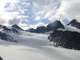
Important parts of the Stubai Alps show signs of glaciation. The northern part around the Sellrain valley and the Kühtai is now only lightly glaciated and a popular ski touring destination (Zischgeles, Lampsenspitze, Pirchkogel, Sulzkogel). The High Stubai around the upper Stubai valley is still heavily glaciated and a classic high mountain touring region in the Eastern Alps. Here there is a glacier ski area on the Stubai Glacier.
Together with the Ötztal Alps to the west, with which they are linked by the saddle of Timmelsjoch, the Stubai Alps form one of the biggest mountain blocks of the Eastern Alps.
Boundary and neighbouring mountain groupsEdit
In the Alpine Club classification of the Eastern Alps (AVE) the Stubai are no. 31. Their boundary follows the following line:
in the north, it follows the course of the River Innin the northwest, it follows the Inn from its confluence with the Ötztaler Ache (near Ötztal railway station) to the confluence with the Gurglbach (near Imst), then to the Mieming Chain (AVE 4) in the Northern Limestone Alpsin the north, it follows the River Inn to Innsbruck, which divides the Stubai Alps from the Karwendel (AVE 5) in the Northern Limestone Alpsin the east, it is formed by the Wipptal valley:in the northeast it follows the Sill to its confluence with the Schmirnbach (Schmirntal) near St. Jodok, opposite the Tux Alps (AVE 33)in the southeast, it follows the Sill to the Brenner Pass – Eisack to Sterzing, which separates the Stubai Alps from the Zillertal Alps (AVE 35)in the south it follows the lower Ridaunbach – Jaufenbach (Jaufental) – Jaufen Pass – St. Leonhard in Passeier, a line which divides it from the Sarntal Alps (AVE 32, which are counted as part of the Central Eastern Alps)in the west, it follows the line: Passeiertal – Schönauer Alm – Timmelsjoch – Timmelsbach – Gurgler Ache – Ötztaler Ache (the whole Ötz valley) to its confluence with the Inn, forming the boundary to the Ötztal Alps (AVE 30)The Alpine Club guide to the Stubai Alps divides the range into 15 subgroups as follows:
Northern Sellrain Mountains (Nördliche Sellrainer Berge), highest peak: Rietzer Grießkogel, 2,884 mSouthwestern Sellrain Mountains (Südwestliche Sellrainer Berge), highest peak: Gleirscher Fernerkogel, 3,194 mSoutheastern Sellrain Mountains (Südöstliche Sellrainer Berge), highest peak: Hohe Villerspitze, 3,092 mLarstig Mountains (Larstiger Berge) + Bachfallenstock, highest peak: Strahlkogel, 3,295 mAlpein Mountains (Alpeiner Berge), highest peak: Schrankogel, 3,497 mHabicht-Elfer-Kamm, highest peak: Habicht, 3,277 mSerleskamm, highest peak: Kirchdachspitze, 2,840 mSulztalkamm, highest peak: Wilde Leck, 3,361 mWestern Main Chain (Westlicher Hauptkamm), highest peak: Zuckerhütl, 3,507 m (also the highest mountain in the entire Stubai Alps)Central Main Chain (Mittlerer Hauptkamm), highest peak: Wilder Freiger, 3,418 mEastern Main Chain (Östlicher Hauptkamm), highest peak: Pflerscher Tribulaun, 3,097 mWindach-Brunnenkogelkamm, highest peak: Jochköpfl, 3,143 mBotzergruppe + foothills, highest peak: Botzer, 3,250 mAggls-Rosskopf-Kamm, highest peak: Agglsspitze, 3,196 mKalkkögel, highest peak: Schlicker Seespitze, 2,804 mThe ten highest peaks in the Stubai Alps are:
Zuckerhütl, 3,507 mSchrankogel, 3,497 mPfaffenschneide, 3,498 mRuderhofspitze, 3,474 mSonklarspitze, 3,463 mWilder Pfaff, 3,456 mWilder Freiger, 3,418 mÖstliche Seespitze, 3,416 mSchrandele, 3,393 mHohes Eis, 3,388 mThere is a total of just under 500 named and surveyed mountains in the Stubai Alps. Amongst the better known are (in order of height and excluding the top ten above):
Wilde Leck, 3,361 mStubaier Wildspitze, 3,341 mSchaufelspitze, 3,332 mLüsener Fernerkogel, 3,298 mBreiter Grießkogel, 3,287 mHabicht, 3,277 mÖstlicher Feuerstein, 3,268 mSchneespitze, 3,178 mPflerscher Tribulaun, 3,097 mHohe Villerspitze, 3,087 mWeißwandspitze, 3,017 mSulzkogel, 3,016 mHochreichkopf, 3,010 mZischgeles, 3,004 mRoter Kogel, 2,832 mGamskogel, 2,813 mSchlicker Seespitze, 2,804 mSerles, 2,717 mHoher Burgstall, 2,611 mLämpermahdspitze 2,595 mElferspitze, 2,505 mGargglerin, 2,470 mSaile (Nockspitze), 2,404 mThe main mountain passes of the Stubai Alps are: