
Length 1,114 km | Discharge 390 m³/s | |
 | ||
- average 13,773 cu ft/s (390 m/s) - max 159,000 cu ft/s (4,502 m/s) Basin 70,000 sq mi (181,299 km2) Similar Yellowstone National Park, Yellowstone Lake, Old Faithful, Grand Canyon of the Yello, Upper Yellowstone Falls | ||
Dangers of the yellowstone river 122
The Yellowstone River is a tributary of the Missouri River, approximately 692 miles (1,114 km) long, in the western United States. Considered the principal tributary of the upper Missouri, the river and its tributaries drain a wide area stretching from the Rocky Mountains in the vicinity of the Yellowstone National Park across the mountains and high plains of southern Montana and northern Wyoming.
Contents
- Dangers of the yellowstone river 122
- Map of Yellowstone River United States
- Yellowstone WatershedEdit
- GeographyEdit
- HistoryEdit
- Climate PatternsEdit
- 2011 oil spillEdit
- 2015 oil spillEdit
- 2016 river closureEdit
- FishingEdit
- AdvocatesEdit
- References
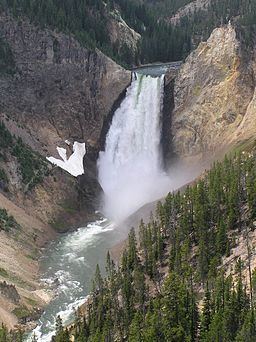
Map of Yellowstone River, United States
Yellowstone WatershedEdit
The Yellowstone River Watershed is a river basin located in North Dakota, Wyoming, and Montana. The Yellowstone Basin Watershed contains a system of rivers, including the Yellowstone River, and four tributary basins: the Clarks Fork Yellowstone, Wind River and Bighorn River, Tongue River, and Powder River. These rivers form tributaries to the Missouri River. The mainstem of the Yellowstone River is more than 1,130 kilometres (700 mi) long. At the headwaters, elevations exceed 3,900 metres (12,800 ft) above sea level and descends to 564 metres (1,850 ft) at the confluence with the Missouri River in North Dakota. The watershed spans 34,167 square miles. The area contains many lakes, including Yellowstone Lake. There are no storage dams located on the mainstem of the Yellowstone River. However, the watershed contains five major reservoirs: Bull Lake, Boyson, Buffalo, Bighorn, Tongue River, and Lake De Smet reservoirs.
GeographyEdit
The river rises in northwestern Wyoming in the Absaroka Range, on the Continental Divide in southwestern Park County. The river starts where the North Fork and the South Fork of the Yellowstone River converge. The North Fork, the larger of the two forks, flows from Younts Peak. The South Fork flows from the southern slopes of Thorofare Mountain. The Yellowstone River flows northward through Yellowstone National Park, feeding and draining Yellowstone Lake, then dropping over the Upper and Lower Yellowstone Falls at the head of the Grand Canyon of the Yellowstone within the confines of the park. After passing through the Black Canyon of the Yellowstone downstream of the Grand Canyon, the river flows northward into Montana between the northern Absaroka Range and the Gallatin Range in Paradise Valley. The river emerges from the mountains near the town of Livingston, where it turns eastward and northeastward, flowing across the northern Great Plains past the city of Billings.
East of Billings, it is joined by the Bighorn River. Further downriver, it is joined by the Tongue near Miles City, and then by the Powder in eastern Montana. It flows into the Missouri River near Buford, North Dakota just upstream from Lake Sakakawea.
In Montana the river has been used extensively for irrigation since the 1860s. In its upper reaches, within Yellowstone Park and the mountains of Montana, it is a popular destination for fly fishing. The Yellowstone is a Class I river from the Yellowstone National Park boundary to the North Dakota border for the purposes of stream access for recreational purposes.
The division of water rights to the entire Yellowstone River Basin among Wyoming, Montana and North Dakota, governed by a 1950 compact, was disputed in a 2010 lawsuit brought directly in the U.S. Supreme Court by Montana against Wyoming. Oral argument took place in January 2011. On May 2, 2011, the Court held 7-1 (by Justice Thomas, with Justice Scalia dissenting) that Montana had no valid claim for diminution of its water, since Wyoming was irrigating the same acreage as always, albeit by a more modern method that returned less runoff to go downstream to Montana. (A subsequent 2011 Supreme Court case, in which Montana asserted ownership of Missouri Basin riverbottoms, so as to collect decades of back rent from a hydropower company, is unrelated. On February 22, 2012, Montana lost that case too.)
HistoryEdit
The name is widely believed to have been derived from the Minnetaree Indian name Mi tse a-da-zi (Yellow Rock River) (Hidatsa: miʔciiʔriaashiish'). Common lore states that the name came from the yellow-colored rocks along the Grand Canyon of the Yellowstone, but the Minnetaree never lived along the upper stretches of the Yellowstone. Some scholars think that the river was named after yellow-colored sandstone bluffs on the lower Yellowstone, instead. The Crow Indians, who lived along the upper Yellowstone in Southern Montana, called it E-chee-dick-karsh-ah-shay (Elk River). Translating the Minnetaree name, French trappers called the river Roche Jaune (Yellow Rock), a name used by mountain men until the mid-19th century. Independently, Lewis and Clark recorded the English translation of Yellow Stone for the river, after encountering the Minnetaree in 1805. With expanding settlement by people from the United States, the English name eventually became the most widely used. The river was explored in 1806 by William Clark during the return voyage of the Lewis and Clark Expedition. Clark's Fork of the river was named for him.
The Yellowstone River had long been an important artery of transportation for Native Americans. In the 19th century, European-American settlers depended on it as well, entering the region by riverboat. The region around the Big Horn, Powder and Tongue rivers is the traditional summer hunting grounds for numerous Native American tribes: Lakota Sioux, Crow, Cheyenne and Cree. Gold was discovered near Virginia City, Montana in the 1860s, and two of the primary routes for accessing the gold fields were the Bozeman Trail and the Bridger Trail both of which followed the Yellowstone for a short length.
Native American anger at settler intrusion into the hunting grounds led to Red Cloud's War. The conflict was settled with the Treaty of Fort Laramie in 1868, by which the US granted the territory of the Black Hills and the Powder River Country to the Lakota people. This region included the drainages of the Big Horn, Powder and Tongue rivers. The discovery of gold in 1874 in the Black Hills, however, attracted thousands of miners who invaded the sacred grounds, and conflicts broke out with the Sioux.
The new competition and violence led to the Great Sioux War of 1876-77. The US sent in troops to protect the miners, although they had violated the treaty, and to defeat the Sioux. In 1876, Colonel John Gibbon led a column of men from Fort Ellis near Bozeman, Montana and traveled down the Yellowstone to meet up with General Alfred Terry's Dakota Column, which had traveled upstream from North Dakota. Terry formed a base of operations at the mouth of Rosebud Creek on the Yellowstone, but the US miscalculated the strength of the Lakota who had gathered by the thousands along the river. General George Armstrong Custer departed from Rosebud Creek with the 7th Cavalry on the expedition that ended in his complete defeat by the Lakota and Cheyenne at the Battle of the Little Bighorn. The army ferried its survivors down the Yellowstone to Fort Abraham Lincoln on the Missouri River.
After the US achieved victory the tribes were forced onto reservations. The Sioux and allies were forced from eastern Montana and Wyoming: some bands fled to Canada, while others suffered forced removal to distant reservations, primarily in present-day South Dakota and Nebraska west of the Missouri River. Crow warriors had enlisted as scouts with the US Army during the war and the Crow Indian Reservation was established in south-central Montana. The Northern Cheyenne Indian Reservation is south of the Yellowstone in Montana.
Many of the early expeditions to the area that would later become Yellowstone National Park traveled along the Yellowstone River, including the Cook–Folsom–Peterson Expedition and the Washburn-Langford-Doane Expedition. In the early 1870s, the Northern Pacific Railroad attempted to extend rail service along the Yellowstone to Livingston from Bismarck, North Dakota, a route proposed to cross the last of the Lakota buffalo hunting grounds. This route was finally completed in 1883. By the early 20th century, Northern Pacific was providing train service along the river to the north entrance of the park near Gardiner.
Climate PatternsEdit
Flooding occurs in the watershed due to snowmelt, rainfall, and intense thunderstorms. In higher elevations, snowmelt can cause flood conditions due to rapid snowmelt in spring and early summer. In lower elevations, regional rainstorms and intense thunderstorms can cause flooding in summer and fall. Severe droughts have occurred in the Yellowstone Watershed lasting several years. Droughts have occurred in the basin in 1929-42, 1948–62 and 1976-82. The 1977 drought affected most the western United States and lead to decreased streamflows in the watershed. The reduced flow increased dissolved solids concentrations in the basin. Water quality varies across the various rivers in the basin. In mountainous areas, suspended sediment and dissolved solid concentrations are lower than in basin and plain areas. Human activities, including agriculture and mining, along with natural sources contribute to suspended sedimentation levels in plain areas. In addition, fecal bacteria, salt, and selenium contamination is present in some streams within the watershed.
2011 oil spillEdit
ExxonMobil pipeline which runs from Silver Tip, to Billings, Montana, ruptured about 10 miles (16 km) west of Billings on Friday, July 1, 2011, at about 10:40 p.m. The resulting spill leaked an estimated 1,500 barrels of oil, equivalent to 63,000 US gallons (240,000 l; 52,000 imp gal), into the Yellowstone River for 56 minutes before it was shut down. As a precaution against a possible explosion, officials in Laurel, Montana evacuated about 140 people on Saturday just after midnight, then allowed them to return at 4 a.m. Montana Governor Brian Schweitzer stated that "The parties responsible will restore the Yellowstone River".
2015 oil spillEdit
According to the Bridger Pipeline LLC, another oil spill occurred near Glendive on January 17, 2015, at 10 a.m. In response, the pipeline company shut down the pipeline at 11 a.m. in effort to prevent further environmental hazards. The company stated that 300–1,200 oil barrels (equivalent to 12,600 to 50,400 US gallons) were spilled into the river. State officials estimated, on the other hand, up to 50,000 US gallons (190,000 l; 42,000 imp gal) of spilled oil. Benzene, a carcinogen, was found in ten to fifteen parts per billion. An EPA official said that "anything above five parts per billion is considered a long-term risk." Nearly 6,000 people were told not to use municipal water in Glendive due to the elevated levels of cancer-causing benzene found in the Yellowstone River, and in the tap water supplied. Bottled water was provided to their residents. On January 23, 2015, the city water treatment plant was declared decontaminated. City officials declared tap water safe to consume.
The Wyoming company from True Companies' Poplar pipeline system involved in this incident has an history of nine oil spills in 2006–14 leaking an amount of 11,000 gallons of crude. Also, their sister company Belle Fourche Pipeline owned by Tad True and their family, recorded twenty-one incidents in the same period leaking 272,832 gallons of oil, both companies had federal fines levied against them and appear in governments records. The oil cleanup on Yellowstone River was put on hold for one month or more on February 3, 2015 until the ice melts. Montana Department of Environmental Quality was monitoring an area spanning a ninety-mile stretch of the Yellowstone, from the spill site downstream to a bridge just across the North Dakota border.
2016 river closureEdit
On August 19, 2016 the Montana Department of Fish, Wildlife and Parks Department indefinitely closed the river and its tributaries from the Montana border at Gardiner, Montana to Laurel, Montana to all recreational activity. The 183-mile (295 km) closure resulted from a massive fish kill attributed to proliferative kidney disease, a rare but serious salmonid disease. The parasite--Tetracapsuloides bryosalmonae—is not harmful to humans or other mammals. Wildlife officials estimate tens of thousands of fish may have died, mostly mountain whitefish, but Yellowstone cutthroat and rainbow trout have been affected. The closure is expected to cause significant adverse economic impact to businesses which depend on summer tourist and recreational activities along the river.
On September 1, 2016 the agency reopened two stretches of the river. The first stretch, from the northern boundary of Yellowstone National Park to Carbella, Montana, was open to non-fishing recreation only to allow the fish population to recover. The second stretch, from Carbella, Montana to Laurel, Montana, was opened to all uses.
FishingEdit
The Yellowstone River is considered to be one of the greatest trout streams of the world and is officially classed as a blue ribbon stream in Montana from the park to the confluence with the Boulder River east of Livingston and from the mouth of Rosebud creek near Rosebud, Montana to the North Dakota border. The lack of dams along the river provides for excellent trout habitat from high inside Yellowstone Park, downstream through Gardiner, the Paradise Valley, Livingston, and to Big Timber, a stretch of nearly 200 miles (320 km). The Yellowstone varies in width from 74 feet (23 m) to 300 feet (91 m), so fishing is normally done by boat. The most productive stretch of water is through Paradise Valley in Montana, especially near Livingston which produces brown trout, rainbow trout and native Yellowstone cutthroat trout as well as Rocky Mountain whitefish. From Billings downstream to the North Dakota border, anglers seek burbot, channel catfish, paddlefish, sauger, smallmouth bass, and walleye. The pallid sturgeon (Scaphirhynchus albus), an endangered species endemic to the waters of the Missouri and lower Mississippi River basins, is also found in the Yellowstone.