
Length 64 km | ||
 | ||
- location Tower Junction, Wyoming | ||
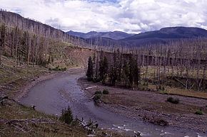
The Lamar River is a tributary of the Yellowstone River, approximately 40 miles (48 km) long, in northwestern Wyoming in the United States. The river is located entirely within Yellowstone National Park.
Contents
Map of Lamar River, Wyoming, USA
HistoryEdit
Prior to the 1884–85 Geological Survey of the park, the Lamar was known as the East Fork of the Yellowstone River. During that survey, Geologist Arnold Hague named the river for L.Q.C. (Lucius Quinctius Cincinnatus) Lamar, then Secretary of the Interior (March 1885 – January 1888). The Lamar Valley, or the Secluded Valley of Trapper Osborne Russell and other park features or administrative names which contain Lamar are derived from this original naming.
Osborne Russell in his 1921 Journal of a Trapper described the Lamar as follows:
Chapter-VI-In the Yellowstone Country-A Garden of Eden Inhabited By a Small Party of Snake Indians - On the 28th [July 1834] we crossed the mountain in a westerly direction through the thick pines and fallen timber, about twelve miles, and encamped in a small prairie about a mile in circumference. Through this valley ran a small stream in a northerly direction, which all agreed in believing to be a branch of the Yellowstone. 29th-We descended the stream about fifteen miles through the dense forest and at length came to a beautiful valley about eight miles long and three or four wide, surrounded by dark and lofty mountains. The stream, after running through the center in a northwesterly direction, rushed down a tremendous canyon of basaltic rock apparently just wide enough to admit its waters. The banks of the stream in the valley were low and skirted in many places with beautiful cottonwood groves. Here we found a few Snake Indians comprising six men, seven women and eight or ten children, who were the only inhabitants of the lonely and secluded spot.
In 1869, the Cook–Folsom–Peterson Expedition encountered the Lamar River (East Fork) just upstream from the canyon section flowing into the Yellowstone and traveled upstream to the confluence of Calfee Creek where they camped on September 16, 1869.
Location and tributariesEdit
It rises in the Absaroka Range, on the eastern edge of the park, and flows northwest through the northeast corner of the park. It is joined by many tributary streams, including Soda Butte Creek and Slough Creek and joins the Yellowstone near Tower Junction, just below the Grand Canyon of the Yellowstone.
The river is a popular destination for fly fishing, and is widely known as one of the best places in Yellowstone National Park to view wildlife, especially grizzly bears and wolves. Three locations in the valley—Soda Butte, Crystal Creek and Rose Creek were the sites for the 1995 re-introduction of wolves into Yellowstone. The river flows through a portion of the park hit hard by the 1988 wildfires.