
Width 2 km (1.2 mi) Prefectures Hokkaidō Area 5.21 km² | Length 4 km (2.5 mi) Highest elevation 97 m (318 ft) Elevation 94 m | |
 | ||
Highest point Central Yagishiri Island | ||
2016 teuri island yagishiri island pv long ver english edition
Yagishiri Island (焼尻島, Yagishiri-tō) is a small, sparsely populated island in the Sea of Japan, located 23 kilometres (14 mi) northwest of Haboro Bay in Haboro, Hokkaido. The island, along with neighboring Teuri Island, belongs to the town of Haboro in Tomamae District, Rumoi Subprefecture. The island is noted for its dense forests, and fully two-thirds of Yagishiri Island remains forested.
Contents
- 2016 teuri island yagishiri island pv long ver english edition
- Map of Yagishiri Island Yagishiri Haboro Tomamae District Hokkaido Prefecture 078 3871 Japan
- How to get to yagishiri island
- History
- Geography
- Yagishirit Lighthouse
- Forest of Yagishiri
- Transportation
- References
Map of Yagishiri Island, Yagishiri, Haboro, Tomamae District, Hokkaido Prefecture 078-3871, Japan
How to get to yagishiri island
History
Yagishiri Island, like nearby Teuri, became a base for the fishing of Pacific herring beginning in 1786. In the modern period Yagishiri Island has seen a long-term population decline: in 1947 there were 2,283 residents, by 1972 the number had fallen to 1,073, and in 2010 the population had fallen to 273.
Geography
Yagishiri is located 3.5 kilometres (2.2 mi) east of Teuri Island, and the two islands are separated by the Musashi Channel. The island is approximately 4 kilometres (2.5 mi) long from east to west, 2 kilometres (1.2 mi) from north to south, and covers 5.34 square kilometres (2.06 sq mi). It has a coastline of roughly 12 kilometres (7.5 mi).
Yagishiri is flatter than nearby Teuri, and reaches an elevation at its center of only 97 metres (318 ft). Yagishiri Island is primarily composed of Tertiary-period andesite formed into a four marine terraces, some with significant marine cliffs.
Yagishiritō Lighthouse
The island has a single lighthouse, Yagishiritō Lighthouse, located 40 metres (130 ft) above sea level just south of the small Port of Yagishiri. The lighthouse is a 13 metres (43 ft) concrete structure, painted white, and was constructed in February 1913. The Yagishiritō Lighthouse has an intensity of 7,000 candela.
Forest of Yagishiri
Yagishiri Island is noted for its dense forest. The island was once completely covered with trees, but major parts of the forest were used for housing and other construction with the start of the trade of Pacific herring in the late 18th century. A prohibition was put in place on the cutting of trees on the island in 1880 to prevent the complete deforestation of the island. Shortly afterward, in 1886, two thirds of the forest of Yagishiri was lost to a fire. The island has been significantly reforested, with the Uguisu Valley in the center of the island remaining untouched by development or fire. Climatic conditions on the Japan Sea keep the canopy of the forest, specifically in the Uguisu Valley, as low as 10 metres (33 ft), and the trunks of various species of trees in the forest are correspondingly thick. The forest is homes to 50 species of trees, but Yagishiri Island is noted for its unspoiled stands of Taxus cuspidata, the Japanese yew. The forest of Yagishiri is a protected natural monument of Japan, and the entirety of the island is protected as a part of Shokanbetsu-Teuri-Yagishiri Quasi-National Park.
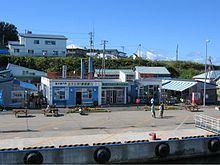
Transportation
Yagishiri Island is connected by two ferries to the port at Haburo. The island is reached by the Ororon 2 in 60 minutes, and the Sanraina in 35 minutes. In winter is served by one trip per day by the Orororan 2, and at the peak tourist season in August the ferries each run three times per day. A single road, the Yagishiri Road (焼尻島線, Yagishi Tōsen), circles the island.