
Population 52,627 (Dec 2011) | Area 4,020 km² | |
 | ||
Website www.rumoi.pref.hokkaido.lg.jp(Japanese) | ||
Rumoi Subprefecture (留萌振興局, Rumoi-shinkō-kyoku) is a subprefecture of Hokkaido Prefecture, Japan. As of 2011, it had a population of 52,627 and an area of 4,019.97 square kilometres (1,552.12 sq mi). The population density of the subprefecture, 13 people per km2, is very low compared to the rest of Japan. The population of Rumoi Subprefecture represents 0.96% of the overall population of Hokkaido.
Contents
Geography
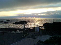
Rumoi Subprefecture stretches broadly across the coast of the Sea of Japan in northwestern Hokkaido.
Cities
Towns and villages by district
Rivers
The Rumoi River 44 kilometres (27 mi) flows from Mount Poroshiri in the Hidaka Mountain range to the Sea of Japan.
History
Mashike Subprefecture was established as part of the administrative reforms of Hokkaido during the Meiji period (1868 – 1912). The capital was moved to Rumoi in 1914, and the subprefecture was renamed to Rumoi Subprefecture in the same year. Toyotomi Town) in Teshio District transferred to Sōya Subprefecture in 1948, and Horonobe was transferred to Sōya Subprefecture in 2010.
Economy
The fishing industries dominates the economy of the area, and seafood processing remains a thriving industry.