
Highest elevation 184.5 m (605.3 ft) Prefectures Hokkaidō Elevation 184 m | Coastline 12 km (7.5 mi) Highest point Southwest Teuri Island Area 5.5 km² | |
 | ||
2016 teuri island yagishiri island pv long ver english edition
Teuri Island (天売島, Teuri-tō) is an island of the western coast of Hokkaidō, Japan in the Sea of Japan. It covers 5.5 square kilometres (2.1 sq mi). The island, along with neighboring Yagishiri Island, belongs to the town of Haboro in Tomamae District in Rumoi Subprefecture. Teuri Island has seen a long-term population decline: in 1947 there were 2,051 residents, by 1972 the number had fallen to 1,030, and in 2010 the population was 366.
Contents
- 2016 teuri island yagishiri island pv long ver english edition
- Map of Teuri Island Teuri Haboro Tomamae District Hokkaido Prefecture 078 4100 Japan
- Rhinoceros auklet at teuri island japan
- References
Map of Teuri Island, Teuri, Haboro, Tomamae District, Hokkaido Prefecture 078-4100, Japan
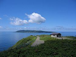
Teuri Island is located 3.5 kilometres (2.2 mi) west of Yagashiri, and the two islands are separated by the Musashi Channel. The Teuritō Lighthouse is located to the north of the island. The southwest of Teuri Island reaches an altitude of 184.5 metres (605 ft), and is noted for its continuous marine cliffs. The island became a base for the fishing of Pacific herring beginning in 1786.
Teuri Island is a sanctuary for nesting seabirds, notably the common murre and the black-tailed gull, and is part of Shokanbetsu-Teuri-Yagishiri Quasi-National Park. There are four viewing platforms built on the island to observe various species of birds.