
Length 3,700 km | Discharge 878 m³/s | |
 | ||
- average 878 m/s (31,006 cu ft/s) Bridges Omdurman Bridge, New Jinja Bridge, Goz Abu Goma Bridge | ||
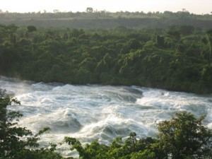
Gopro kayaking big wave surfing white nile uganda africa
The White Nile (Arabic: النيل الأبيض an-nīl al-'abyaḍ) is a river of Africa, one of the two main tributaries of the Nile; the other is the Blue Nile.
Contents
- Gopro kayaking big wave surfing white nile uganda africa
- Map of White Nile
- Murchison falls on the white nile uganda
- Headwaters of Lake Victoria
- In Uganda
- The Mountain Nile
- References
Map of White Nile
In the strict meaning, "White Nile" refers to the river formed at Lake Victoria, at the confluence of the Bahr al Jabal and Bahr el Ghazal Rivers. In the wider sense, "White Nile" refers to the rivers draining from Lake Victoria into the White Nile proper (Victoria Nile, Kyoga Nile, Albert Nile, Bahr-al-Jabal). It may also, depending on the speaker, refer to the headwaters of Lake Victoria (about 3,700 kilometres (2,300 mi) from the most remote sources down to Khartoum)
The 19th century search by Europeans for the source of the Nile was mainly focused on the White Nile, which disappeared into the depths of what was then known as "Darkest Africa". The White Nile's true source was not discovered until 1937, when the German explorer Burkhart Waldecker traced it to a stream in Rutovu, at the base of Mount Kikizi.
When in flood, the Sobat River tributary carries a large amount of sediment, adding greatly to the White Nile's color.
Murchison falls on the white nile uganda
Headwaters of Lake Victoria
The Kagera River, which flows into Lake Victoria near the Tanzanian town of Bukoba, is the longest feeder river for Lake Victoria, although sources do not agree on which is the longest tributary of the Kagera and hence the most distant source of the Nile itself.
The source of the Nile can be considered to be either the Ruvyironza, which emerges in Bururi Province, Burundi, near Bukirasaz or the Nyabarongo, which flows from Nyungwe Forest in Rwanda.
The two feeder rivers meet near Rusumo Falls on the Rwanda-Tanzania border. The falls are notable because of an event on 28–29 April 1994, when 250,000 Rwandans crossed the bridge at Rusumo Falls into Ngara, Tanzania in 24 hours, in what the United Nations High Commissioner for Refugees called "the largest and fastest refugee exodus in modern times". The Kagera forms part of the Rwanda–Tanzania and Tanzania–Uganda borders before flowing into Lake Victoria.
In Uganda
The river arising from Lake Victoria is known as the "Victoria Nile". The place where it arises, just outside Jinja, is marked by a monument. After Nalubaale Power Station and Kiira Power Station at the mouth, the river goes through Bujagali Falls (location of Bujagali Power Station) about 15 kilometres (9.3 mi) downstream from Jinja.
It then flows north and westwards through Uganda, feeding into Lake Kyoga in the centre of the country and then out west. At Karuma Falls, the river sweeps under Karuma Bridge (2°14′45.40″N 32°15′9.05″E) at the south-eastern corner of Murchison Falls National Park.
During much of the insurgency of the Lord's Resistance Army, Karuma Bridge, built in 1963 to help the cotton industry, was the key stop on the way to Gulu, where vehicles would gather in convoy before being provided with a military escort for the final run north.
In 2009, the government of Uganda announced plans to construct a 750-megawatt hydropower project several kilometres north of the bridge, which is scheduled for completion in 2016. The World Bank had approved funding a smaller 200-megawatt power plant, but Uganda opted for a bigger project, which the Ugandans will fund internally, if necessary.
Just before entering Lake Albert, the river is compressed into a passage 7 metres (23 ft) in width at Murchison Falls, marking the entry into the western branch of the East African Rift. The river flows into Lake Albert opposite the Blue Mountains in the Democratic Republic of the Congo.
The river exiting Lake Albert to the north is known as the "Albert Nile". It separates the West Nile sub-region of Uganda from the rest of the country. A bridge passes over the Albert Nile near its inlet in Nebbi District, but no other bridge over this section has been built. A powered ferry connects the roads between Adjumani and Moyo: navigation of the river is otherwise done by small boat or canoe.
The Mountain Nile
The Albert Nile continues north to Nimule, where it enters South Sudan and becomes known as the "Mountain Nile" or "Baḥr al-Jabal" (also "Baḥr el-Jebel", بحر الجبل), literally Mountain River" or "River of the Mountain". Bahr al Jabal also formerly lent its name to the state of Central Equatoria.
The Bahr al-Jabal then winds through rapids before entering the Sudan plain and the vast swamp of the Sudd. It makes its way to Lake No, where it merges with the Bahr el Ghazal and there forms the White Nile. An anabranch river called Bahr el Zeraf flows out of the Bahr al-Jabal at and flows through the Sudd, to eventually join the White Nile.
The Bahr al-Jabal passes through Juba, the capital of South Sudan, which is the southernmost navigable point on the Nile river system, and then to Kodok, the site of the 1898 Fashoda Incident that marked an end to the Scramble for Africa.
The river flows north into Sudan and lends its name to the Sudanese state of White Nile, before merging with the larger Blue Nile at Khartoum, the capital of Sudan, and forming the River Nile.