
Population 649 (2011 census) Civil parish n/a Area 2.86 km² Dialling code 01306 | OS grid reference TQ1652 Sovereign state United Kingdom Local time Saturday 12:07 PM UK parliament constituency Mole Valley | |
 | ||
Weather 13°C, Wind SW at 18 km/h, 67% Humidity | ||
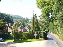
Westhumble /wɛstˈhʌmbəl/ is a clustered village centred 2 km (1.2 mi) north of Dorking in Surrey, England, in the parish of Mickleham but without a civil parish.
Contents
- Map of Westhumble Dorking UK
- History
- Demography and housing
- Buses
- Trains
- Cycling
- Roads
- Local government
- Famous residents
- References
Map of Westhumble, Dorking, UK
The area is served by Box Hill & Westhumble railway station.
At the start of a wide belt of country fields, meadows and National Trust landmarks, such as Box Hill and Polesden Lacey by its borders, Westhumble is a focus for ramblers, it was never a historic parish in its own right and remains a chapelry (and in old-fashioned language, a hamlet) of Mickleham, which is across the river, north-east. The Mole Gap Trail runs through the village, the North Downs Way runs perpendicular, crossing the Mole Gap Trail, less than 0.40 km (0.25 mi) to the south and the railway station is the southerly end point for the Thames Down Link from the river at Kingston upon Thames. Immediately starting from its western border on the River Mole are the main paths up the slopes of Box Hill.
History
The earliest archaeological evidence for human activity in the village is a large axe, typical of a "rough-out" axe produced during the Neolithic period, which was discovered in 1952 during building work in Burney Road. The discovery of a Flint Mine at East Horsley and flakes of flint found at Fetcham and Headley Heath of the same period, suggest that this part of the North Downs had been settled by the late Stone Age (10 000–3000 BC).
The earliest mention of the 'village' (it is more accurately a chapelry or 'hamlet') is in the Assizes Rolls of 1248, in which it appears as Wystumble. The name is thought to derive from the Old English wice meaning wych elm and the Middle English stumbel meaning tree stump. The village is not explicitly mentioned in Domesday Book, however there are two separate entries for the Parish of Mickleham, in which much of the village is located, and it is probable that the second of these refers to Westhumble. The medieval village was centred on the present-day midpoint of Adlers Lane with gently sloping fields to the north and south. The identity of the manor house is unclear, however there are repeated references to Hadlers Hall and later Audlers Hole in the Court Roll records. It has been suggested that the hall was the original manor house. There is no trace of the house today.
The oldest building is the ruined chapel at the extreme west end of the village, of which only the west gable and parts of the east end remain. The chapel was probably not part of the medieval manor of Westhumble, but was located in the manor of Polesden (centred on Chapel Farm, which is of medieval origin). Reference is made in the Surrey Feet of Fines during the reign of King John 1199–1216 to "Adam the canon in Fecham and Polesdene" a subordinate of the Prior of Merton and it is probable that the chapel was the responsibility of this Canon. The chapel is thought to have been built during the late twelfth or early thirteenth century for the use of villagers, particularly when floods prevented them from reaching the Parish Church in Mickleham. Six skeletons were found during an archaeological survey in 1937 and the manner in which they were interred suggests that they were ordinary local burials. Clay cooking pots and jugs dating from around 1300 and a silver penny dating from 1544–1547 during the reign of Henry VIII were also found on the site. The chapel was probably abandoned as a place of worship during the mid-sixteenth century, although part of it was probably used as a farm outbuilding for some time. Repairs to the remaining walls were carried out during 1938 and the site is now owned by the National Trust.
Much of the early history of the village is uncertain, because the manorial records were deliberately destroyed by fire in 1776. During the late Middle Ages and Early Modern periods, it would appear that the focal point of the village shifted half a mile eastwards from Adlers Lane to Westhumble Street. The shift in position may have reflected the growing importance of the north-south road through the Mole Gap and the relative decrease in importance of the east-west route along the North Downs. Although the turnpike through the valley was not completed until 1755, the route was regularly being used to transport goods including charcoal and poultry to Kingston and London by the 14th century. For much of the winter the ford across the River Mole would have been impassable and so a secondary route on higher ground along the western side of the valley was used, of which Westhumble Street formed the southernmost part. The name Westhumble Street is first recorded in 1736 (some 19 years before the construction of the turnpike) and the use of the word street in the context of a village of this period, suggests that the road surface was improved with metalling. It seems likely that the villagers sought to take advantage of the passing trade and the movement of the village centre was confirmed with the construction of the new manor house, Camilla Lacey, north of Chapel Lane in 1816.
Much of the modern village dates from the two decades following the break-up and sale of the Camilla Lacey estate in 1932 following the death of the owner Victor Freeman. By the outbreak of World War II, most of the houses in Pilgrims Way had been built although those in Burney Road, Adlers Lane and Pilgrims Close were not constructed until the late 1940s.
Demography and housing
The average level of accommodation in the region composed of detached houses was 28%, the average that was apartments was 22.6%.
The proportion of households who owned their home outright compares to the regional average of 35.1%. The proportion who owned their home with a loan compares to the regional average of 32.5%. The remaining % is made up of rented dwellings (plus a negligible % of households living rent-free).
Buses
The 465 bus from Dorking to Kingston passes by a stop for the Box Hill roundabout. Its service is half-hourly until the later evening when it is hourly.
Trains
Box Hill and Westhumble station is in the middle of the village. Journey time to London Waterloo (via Clapham Junction) is 53/54 minutes (peak hours only) and 48–59 minutes to London Victoria (via Clapham Junction). Note that as at 2012, although two train operating companies serve the station, based on the national ticketing policy for non-express services, there is no price differential to destinations.
Cycling
Beside the A24 dual carriageway, following the Mole, from here south is a wide NCN standard cycle path (marked and less used by pedestrians): south and northeast of the Box Hill roundabout this is route 22 from south London to Alton, Hampshire; north this is designated Surrey Cycle route 5 with wide roads into Leatherhead or for the western A246 turn off towards Great Bookham and Guildford.
West through the village and up into the hills including Ranmore Common to Guildford is one of a choice of rural routes in the Surrey Cycleway.
The 2012 Summer Olympics road races started at The Mall in central London, extended into Surrey to the south via Weybridge, Ripley and Dorking then took the A24 next to the NCN cycling path at the foot of the village to return to The Mall via Leatherhead, Oxshott, Hampton Court Palace and Kingston-upon-Thames.
Roads
The village is immediately west of the dual A24 between Dorking and Leatherhead with easy access after those towns to the M25 motorway, outer parts of London and Brighton to the south, and before Leatherhead taking the A243 to Guildford.
Local government
The area forms just under a third in terms of population of one of the wards of the United Kingdom Mickleham, Westhumble and Pixham that had in 2011 a total population of 1,932. and has the right to elect two councillors to Mole Valley Borough Council.
Famous residents
Fanny Burney, the 18th-century novelist, built a house in the village in 1797 with her husband, the French general, Alexandre D'Arblay.
The detective story writer Cyril Hare was born in Mickleham in 1900 and lived from 1951 until his death in 1958 in Westhumble, at Berry's Croft opposite Cleveland Lodge. As Judge A. A. Gordon Clark he sat in Dorking county court among others.
The physicist and astronomer Sir James Jeans and his wife, the organist Susi Jeans, lived at Cleveland Lodge. Susi Jeans hosted an annual music festival at Cleveland Lodge from 1954; initially known as the Mickleham and Westhumble Festival, it was renamed the Boxhill Music Festival in 1966. The final festival was held in June 1992 a few months before her death in January 1993.