
Highest point Mount Geikie | Elevation 1,275 m Type of rock Diabase | |
 | ||
Mountains | ||
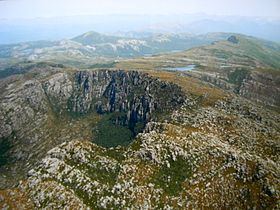
The West Coast Range is a mountain range located in the West Coast region of Tasmania, Australia.
Contents
- Geographical features
- Mountains
- Smaller hills and features
- Rivers
- Lakes
- Reserves
- Vegetation
- Climate
- History and exploration
- Mining
- Hydro Dams
- Pieman River Scheme
- King River Scheme
- Transport
- Railways
- Roads
- Landing grounds
- Historical features and recent sites
- Geological mapping
- References
The range lies to the west and north of the main parts of the Franklin-Gordon Wild Rivers National Park.
The range has had a significant number of mines utilising the geologically rich zone of Mount Read Volcanics. A number of adjacent ranges lie to the east: the Engineer Range, the Raglan Range, the Eldon Range, and the Sticht Range but in most cases these are on a west–east alignment, while the West Coast Range runs in a north–south direction, following the Mount Read volcanic arc.
The range has encompassed multiple land uses including the catchment area for Hydro Tasmania dams, mines, transport routes and historical sites. Of the communities that have existed actually in the range itself, Gormanston, is probably the last to remain.
Geographical features
These are determined by a number of factors - the southerly direction of glaciation in the King River Valley and around the Tyndalls; as well as the general north -south orientation of the West Coast Range itself.
Mountains
The following mountains are contained within the West Coast Range, including sub-ranges without a specifically named peak and also including subsidiary peaks.
Smaller hills and features
Rivers
Lakes
Reserves
Vegetation
The slopes of Mount Owen, Mount Lyell and Mount Sedgwick are covered in stumps of forest trees killed by fires and smelter fumes from the earlier part of the twentieth century. The devastation of forests close to the mining operations at Queenstown was substantial as early as the 1890s and continued late into the twentieth century.
Some Huon Pine on the slopes of Mount Read have been found that show considerable age.
Due to fire, mining and a range of human activities the vegetation zones along the West Coast range can be considered to be mainly modified, and few pockets of vegetation could be considered unchanged since European presence.
The eastern side of the range is on the western boundary of the Franklin-Gordon Wild Rivers National Park, and at these points the forests are in better condition.
Forestry conservation zones exist along its length in accordance with the Regional Forestry Agreement (RFA).
Climate
In the average winter the "1,000 metre snowline" sees most of the mountains with snow. In previous decades, Lake Margaret was the main long-term weather-reporting location, however the Mount Read automatic weather station now maintains extremes regularly reported on the Bureau of Meteorology website for extreme conditions. The rainfall records of Lake Margaret were on a par with Tully in Queensland for the highest rainfall in Australia. Approximations for the West Coast Range are made at 2800–3000 mm precipitation per year.
The prevailing weather is due to the location of the West Coast. It has no landmass shielding it from the Southern Ocean or Antarctic weather, and being in the Roaring Forties cold fronts and extreme weather are regular occurrences on the West Coast. The Cape Sorell Waverider Buoy which was initiated by the BOM in 1998 (there had been earlier testing buoys in the early 1990s) has given good indications of the behaviour of ocean swells to correlate with weather conditions.
Earlier weather records were kept for Queenstown and Zeehan. Due to change in population distribution and resources in the west coast, the main weather data is currently from Strahan Airport and Mount Read.
The following BOM recorded locations are relevant to West Coast Range:
History and exploration
Early European exploration of the range was made by explorers, and by convicts escaping from Macquarie Harbour Penal Station on Sarah Island. Most occurred in the late nineteenth century, but as late as the 1940s some government maps had "unexplored" or "insufficient survey" or words to that effect.
Of the mountains that are viewable from Macquarie Harbour - most were names associated with the proponents for and against the ideas that Charles Darwin was putting forward in the late 19th century.
Thomas Bather Moore named Darwin, Geikie and Read and the Tyndall Range. Charles Gould named 1860 between 1862 Murchison, Sedgwick, Lyell and Owen; Huxley and Jukes were named later.
There were very small mining settlements in the Tyndalls, on Mount Darwin and Mount Jukes, and possibly very small camps of short duration in other locations. Linda in the Linda Valley is probably the only other remaining named location with population in a valley in the range. Queenstown lies in the Queen River valley on the western slopes of Mount Owen, or south western slopes of Mount Lyell, and is in effect 'out' of the range.
Mining
The Tasmanian Mines Department (in its various names over the last hundred years) has had guides to the minerals found in Tasmania - most are found in the West Coast region, these include Barium, Copper, Gold, Pyrites, Silver, Zinc.
Mining sites, in most cases short-lived exist on the upper regions of Mount Darwin, and Mount Jukes. Longer lasting mines existed on the middle slopes of Mount Lyell (North, West and South sides), and on the middle and upper slopes of Mount Read. Mineral exploration has occurred on the slopes of almost all of the named mountains over time. Conservation measures in recent decades have put special restrictions on the activity so as to not replicate the damage of the Mount Lyell operation. A good example of the capacity to mine in a sensitive area is the Henty Gold Mine, at the northern end of the range.
See also West Coast Tasmania Mines for mines that occur on the West Coast Range - and in the West Coast region.
Hydro Dams
The West Coast of Tasmania was always attractive to plans for dams for hydro electricity. The King River was surveyed for this at the time of the First World War.
Then in the 1950s and early 1960s the early HEC surveys were conducted. The upper part of the Pieman scheme dammed parts of the West Coast Range, and the final major projects of the HEC dam making project were the Henty and King River Schemes.
Pieman River Scheme
The Pieman River Power Scheme involved the damming of rivers that start in the West Coast Range. It was the scheme that followed the Gordon River Scheme - and was to be followed by the Franklin River Scheme - but in reality was followed by the King River and Henty River schemes instead.
Construction commenced in 1974 and the scheme was completed by 1987. It involved dams on the Murchison and Macintosh rivers, as well as the Pieman River. The main construction town and administrative centre for the Hydro was at Tullah.
The Mackintosh Dam and power station were north of Tullah, while the Murchsion Dam and Lake were south. A third dam - the Bastyan Dam was just north of Rosebery, while the Reece Dam was a long way to the west - close to the town of Corinna.
King River Scheme
The Crotty Dam is an 82 metre high Hydro Tasmania dam on the King River between Mount Huxley and Mount Jukes. The Darwin Dam is a saddle dam at the foot of Mount Darwin. Both of the dams contain the 54 square kilometre Lake Burbury water storage area.
Transport
Initial access to the west coast region was by foot or by access from the sea - railways progressed further into the region much earlier than roads - the road from Hobart was not connected until the 1930s and the north coast until the 1960s.
Railways
See also:Railways on the West Coast of TasmaniaTo support the Mount Lyell and North Mount Lyell mines, railways were built from ports on Macquarie Harbour and travelled to the edge of the Range. They did not traverse the range.
Similarly the lines that connected with the Emu Bay Railway - the North East Dundas Tramway for example, did not traverse the range, but travelled to the foot of the mountains where the mines were active.
Roads
The Lyell Highway connection running through the West Coast range at the Linda Valley was not constructed until the 1930s.
The road to Crotty from Queenstown (or more correctly the locality of Lynchford), built as the Mount Jukes Road by the Hydro as part of the King River dam scheme in the 1980s passed high above the King River Gorge on the northern side of Mount Jukes.
The Anthony Road constructed by the Hydro during the construction of the Anthony Power Scheme also cuts through the northern part of the range, as well as access to the glacial lakes in The Tyndalls - Lake Westwood, Lake Selina and Lake Julia.
Landing grounds
Although not currently serviced as a registered aerodrome the Queenstown airport (in operation in the 1960s and 1970s) just west of the townsite is the closest air service facility. Strahan Airport is the closest registered airport.
There have been a significant number of temporary helicopter landing sites throughout the range used by Hydro Tasmania and mineral exploration activities - but no inventory is known of these locations.
Historical features and recent sites
Tramways and Railways
through the Crotty and Darwin townsites to Pillinger and Kelly Basin.
Townsites
Mine sites
Hydro sites
Main Roads
Geological mapping
Geological maps of Tasmania: Mount Read Volcanics Project P. Komyshan ...et al. Hobart : Geological Survey of Tasmania, Division of Mines and Mineral Resources, Mount Read Volcanics Project, 1986-1993 - 13 maps : col. ; 92 x 96 cm. or smaller.