
 | ||
The North Mount Lyell Railway was built to service the North Mount Lyell mine in West Coast Tasmania at the start of the Twentieth century to take ore from Gormanston east of the West Coast Range to the Crotty smelters, and then on to Pillinger in the Kelly Basin of Macquarie Harbour, from where it was shipped out.
Contents
The North Mount Lyell Railway had exceptionally easy grades compared to its competitor the Mount Lyell Mining and Railway Company which ran its Abt rack system railway through very steep grades from Queenstown to Regatta Point.
Design challenge
The railway route ran across a belt of karst terrain in the area near the current Darwin Dam - and the engineers of the 1890s were possibly the first in Australia to have designed for the possibility of sinkholes when planning the route.
Operation
The line was opened for passengers 15 December 1900, and was taken over by the Mount Lyell Mining and Railway Company on 16 July 1903. The line was serviced by a small rail motor similar to that on the Lake Margaret Tram in the last years of operation. Due to failure of the Crotty smelters and the North Mount Lyell operations in general, and the amalgamation of the Mount Lyell and North Mount Lyell mines and companies, the railway had a short operational life. It closed to passengers in July 1924 and closed in 1929.
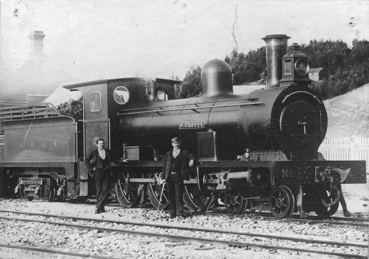
The railway was serviced by three Avonside Engines J.Crotty (No.1)(AE 1392/1899), JP Lonergan (No.2)(AE 1393/1899), and DJ Mackay (No.3)(AE 1394/1899). It also had three Shay engines - Number 4 (Lima 698/1902) - 3 cylinder two truck, Number 5 (Lima 697/1902), Number 6 (Lima 704/1902)
The company also had its own ship (the SS North Lyell) in its service which transported rolling stock to Kelly Basin
After closure
The railway bridge at the King River and the old rail formation were utilised right up to the damming of the River and the creation of Lake Burbury by the Hydro Electric Commission in the 1980s. The railway formation between the Linda Valley and the old locality of Darwin is now under water.
The railway formation between Mount Owen and Mount Jukes was known as the Kelly Basin Road during the No Dams campaign of December 1982 - and was a location of interaction between members of the Tasmanian Police and protesters.
Access
Considerable parts of the old railway line alignment are now under Lake Burbury or destroyed by the related works.
Kelly Basin Road is accessed from Jukes Highway, at one point on the left (gated and locked) a track to one of the sites related to the Franklin Dam is located. Kelly Basin Road (the old formation) reaches a bridge, where access is by foot is needed to complete the journey to Kelly Basin. Walking time is 3 to 4 hours one way, but an easy grade.