
Basin countries Australia | Islands Sarah Island Ocean/sea source Southern Ocean | |
 | ||
Sections/sub-basins Birchs InletHells GatesKelly BasinRegatta Point | ||
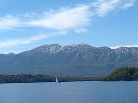
Birchs inlet macquarie harbour tasmania
Macquarie Harbour is a large, shallow, inlet, located in the West Coast region of Tasmania, Australia. The inlet is navigable by shallow draft vessels. The main channel is kept clear by the presence of a rock wall on the outside of the channels curve. This man made wall prevents erosion and keeps the channel deep and narrow, rather than allowing the channel to become wide and shallow.
Contents
- Birchs inlet macquarie harbour tasmania
- Map of Macquarie Harbour Tasmania Australia
- Macquarie harbour tasmania
- History
- Convict era
- Rivers
- Islands
- Settlements
- Named features
- Tourism
- Salmon farms
- References
Map of Macquarie Harbour, Tasmania, Australia
The harbour is named in honour of Scottish Major General Lachlan Macquarie, the fifth Colonial Governor of New South Wales.
Macquarie harbour tasmania
History
James Kelly wrote in his narrative "First Discovery of Port Davey and Macquarie Harbour" how he sailed from Hobart in a small open five-oared whaleboat to discover Macquarie Harbour on 28 December 1815.
However, different accounts of the journey have indicated different methods and dates of the discovery. In the commentary to the Historical Records of Australia, the editor notes that T.W. Birch stated before the commission of inquiry into the state of the colony in 1820 that Kelly had discovered Macquarie Harbour after proceeding along in a boat from Port Davey where they had travelled in the schooner Henrietta Packet. Kelly gave evidence before the commission, and did not mention any discoveries. In a letter dated 11 April 1816, preserved in the record office, London, T.W. Birch transmitted an account of this voyage, which records the discovery of Macquarie Harbour on 26 December 1815.
Charles Whitham notes variations on the date.
Surveyor-General Oxley of New South Wales in March 1820 battled with the seas around the heads and Hells Gates. Surveyor-General Evans travelled in the area in 1821-22.
Convict era
The harbour was established as a prison which was a place of "extreme physical and mental torture" . It was built for British convicts but many Irish patriots and Tasmanian Aborigines were also detained there.
Rivers
The King River which cuts through the West Coast Range and the Gordon River empty into Macquarie Harbour. The narrow entrance to Macquarie Harbour has hazardous tidal currents and is called Hell's Gates. Outside of the Harbour the entrance area is known as Macquarie Heads, and the most western point is Cape Sorell. The sheer volume of fresh water that pours into the Harbour through the rivers, combined with the narrow exit result in barometric tides. When there is rain in the mountains surrounding the Harbour, the tide rises, and it falls when the atmospheric pressure reverses and results in less rain.
The Queen River, King River and Macquarie Harbour were all polluted by mine waste from the Mount Lyell Mining and Railway Company until its closing in 1994. It is estimated that 100 million tonnes of tailings were disposed of into the Queen River. The Mount Lyell Remediation and Research and Demonstration Program was carried out by the office of Supervising Scientist and the Tasmanian Department of Environment and Land Management over the following two years. The result of the program a marked reduction in the waste material entering the rivers and harbour.
Islands
The Islands are regularly surveyed
Settlements
The first settlement at Macquarie Harbour was on Sarah Island, a small island in the harbour. This island was used as a prison for recalcitrant prisoners from other settlements in Tasmania, due to its extreme isolation and extreme climate.
Later the small port of Strahan was developed on the shores of Macquarie Harbour to support the nearby mining settlements, mainly Queenstown. Another port was developed on the south east section of the harbour in Kelly Basin along with townsite of Pillinger. The settlement and port were short lived as was the North Mount Lyell company that developed the facilities.
Named features
Tourism
Today Strahan is the base for tourism on the west coast. The West Coast Wilderness Railway takes part of the north eastern shore of the Harbour, before turning inland at the mouth of the King River.
Boats take tourists to Hell's Gates and Macquarie Heads, Sarah Island and up the lower reaches of the Gordon River. Also charter flights utilise Strahan Airport for helicopter and fixed wing flights.
Salmon farms
Salmon farming, and a range of associated environmental issues in Macquarie Harbour, has been present for some years.
Current management practices have been questioned and challenged
Also the fate of the endangered Maugean skate has been examined in relation to current practices