
Type Geologic unit Primary Sandstone, Siltstone | ||
 | ||
Thickness 200 feet (61 m) max (100-200 ft typical) Extent Underlies Esplanade Sandstone, Supai Group | ||
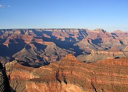
The (Upper) Late Pennsylvanian Wescogame Formation is a slope-forming, sandstone, red-orange geologic unit, formed from an addition of eolian sand, added to marine transgression deposits, (siltstones, etc.), and found throughout sections of the Grand Canyon, in Arizona, Southwest United States. It is one of the upper members of the Supai Group 'redbeds' (member three of four major units), with the Supai Group found in other sections of Arizona, especially in the Verde Valley region, or as a basement unit below the Mogollon Rim, just eastwards or part of the basement Supai Group of the southwest & south Colorado Plateau.
Contents
Coeval units of Wescogame Formation and the Supai Group are replaced by geologic units formed from geology deposited in relationship to the former basin to the south-southeast in Arizona, the Pedregosa Basin, of the Pedregosa Sea, which extended northeast to the Verde Valley region, and the earlier deposition of the red rock sandstone of the Schnebly Hill Formation, of the Sedona, Arizona region, (Oak Creek Canyon, Sycamore Canyon, and other related sub-regions).
Geologic sequence
The Late Pennsylvanian-Early Permian geologic sequence of the Supai Group common in the Grand Canyon: The Pennsylvanian is the Late Carboniferous.
The Supai Group members were created from marine (oceanic) sequences of marine transgression, and regression, thus the alternating sandstone, siltsones, conglomerate subsections (facies); the subsections are not always a continuous transition into the above section, mostly due to ocean levels, falling, or rising, glaciation, or regional subsidence-(basins, etc.) or uplift of land. Today's Wasatch Front is the approximate lineage, NNE to SSW of the western coast region of North America from where the oceans transgressed. The ancient Antler Mountains-(Antler orogeny, off-shore volcanic island arch(es)), of ancient Nevada supplied material, from the west, off the 'ancestral' West Coast. The continent supplied material from the east, both directions supplying the offshore basin, the Cordilleran Basin which became part of the Basin and Range Province, in later epochs. Three other basins were involved in this history: southwest of the Ancestral Rocky Mountains was the Paradox Basin-(eastern Utah to Southwest Colorado), northeast was the Central Colorado Basin-(NW Colorado, NE Utah, SW Wyoming); the Oquirrh Basin was north-northwest, at present day northwest Utah.
Supai Group and Hermosa Group, coeval units
The approximate coeval Supai and Hermosa Groups, Arizona, Utah, and northwest Colorado:
Because marine transgressions cover distances, over time, the coeval units are separated by distance, and type of deposition material; the local subsidence, or uplift, as well as glaciation, and sea level changes, can cause variations in the deposition sequences of transgression-regressions. The ocean was to the west of the proto-North American continent, but also northwest, or southwest.
Fossil footprints
Fossil footprints were first discovered in the area in 1915 by Charles Schuchert. Charles Gilmore visited the Grand Canyon area during the 1920s to collect specimens of these footprints for the Smithsonian Institution. He also wanted to create an exhibit and interpretive center for Paleozoic tracks like these at Hermit Trail. Lockley and Hunt (1995) described Gilmore's work as "successful" and he ended by publishing several papers about the local footprints including those from the Early Permian Hermit Shale and the Middle Permian Coconino Sandstone.