
Length 8.9 mi (14.3 km) Trail difficulty Very Strenuous | Elevation change 4,240 ft (1,290 m) | |
 | ||
Highest point South Rim, 6,640 ft (2,020 m) Sights Grand Canyon, Colorado River Similar Grand Canyon Village, Grand Canyon, Hermits Rest, Grandview Trail, Bright Angel Trail | ||
Nbs off hermit trail grand canyon national park
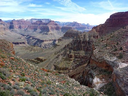
The Hermit Trail is a hiking trail in Grand Canyon National Park, located in the U.S. state of Arizona. This trail provides access to a historic area of Grand Canyon and offers a more challenging route to the Colorado River for more experienced canyon hikers.
Contents
- Nbs off hermit trail grand canyon national park
- Map of Hermit Trail Grand Canyon Village AZ 86023 USA
- Hermit trail of the grand canyon
- Access and description
- Condition
- Water availability
- Camping
- Hazards
- History
- Geology
- References
Map of Hermit Trail, Grand Canyon Village, AZ 86023, USA
Hermit trail of the grand canyon
Access and description
The trailhead is located 0.25 miles (0.40 km) southwest of Hermit's Rest on the South Rim of the Grand Canyon. The trailhead is accessible by shuttle bus from Grand Canyon Village, Arizona on the Hermit Road. The road is closed to private vehicles between April and October annually, and is open to all traffic other months. Two exceptions are for vehicles with government issued handicap placards and backpackers with valid permits for overnight camping in the Hermit use area. Those users can obtain the gate code by visiting the Backcountry Information Center in the park.
Condition
Grand Canyon National Park categorizes the Hermit Trail as a threshold trail and does not officially maintain it. The trail is rutted in many places, and the once exquisite construction of placed stones on the upper half of the trail is now crumbling and rough.
Numerous rockslides cut through the trail and require rock scrambling and route finding to pass. The most recent major rockslide occurred in the evening of 1 March 1983, when a large section of rock in the Supai Group broke away from a cliff face and scattered down Hermit Canyon, cutting the Hermit Trail in two places. A rockslide that took place in the early 1930s cuts through the trail in a third place. These breaks in the trail require scrambling to get over, but are well marked with cairns.
Water availability
All water sources along this trail must be treated, filtered, or boiled before drinking.
Water is available year-round at Hermit Creek and the Colorado River. The trail between the Hermit Creek camping area and the Colorado River parallels Hermit Creek and provides additional water accessibility. Also, water flows periodically from Santa Maria Spring, located 2 trail miles in from the trailhead, but should not be counted on.
Hermit Creek above the Hermit Creek campsite is dry except in time of flood or flash flood.
The park's Backcountry Information Center has current water conditions for all water sources along the Hermit Trail.
Camping
Camping is allowed in designated sites along the Hermit Trail by permit only, issued by the Grand Canyon National Park Backcountry Information Center. Use of these areas overnight are regulated by the National Park Service, and they call for a maximum number of groups (7 to 11 people) and parties (1 to 6 people), as well as a maximum total number of persons.
There are two designated campsites in the Hermit Use Area. The three letter code indicates the park's use area designation:
Use permits are available on a first-come, first-served basis from the park's Backcountry Information Center. Requests are taken beginning on the 1st day of the month, up to four months before the requested first night of camping.
Hazards
Hazards hikers can encounter along the Hermit Trail include dehydration, sudden rainstorms, flash flooding, loose footing, rockfall, encounters with wildlife, and extreme heat. At the Colorado River, additional hazards include hypothermia (due to the river's consistently cold temperatures), trauma (due to collisions with boulders in rapids), and drowning.
History
This trail was built in the last decade of the 19th century by horsetheives, but was improved by different prospectors of that era. The Atchison, Topeka and Santa Fe Railway improved the trail further around 1910 to compete with the Camerons' Bright Angel Trail which charged a toll at the time. The railroad operated Hermit Camp about 7 trail miles below the rim until the 1930s when the National Park Service took over control of the Bright Angel Trail and officially rescinded its tolls.
Geology
Major rocks along this trail include limestone, sandstone, chalk, chert, and other sedimentary rocks, as well as obsidian and igneous rocks. Rocks by the Colorado River are often heavily weathered. Some of the limestone is fossiliferous, mostly representing bivalves.