
 | ||
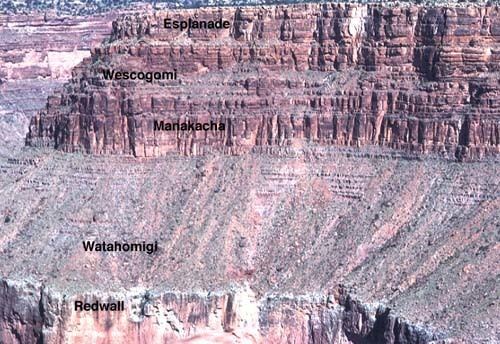
Sub-units 4 named subunits, Esplanade Sandstone, Wescogame Formation, Manakacha Formation, Watahomigi Formation Underlies Hermit Formation-(Permian), Grand Canyon; (Hermit elsewhere in Arizona, (west) Oak Creek Canyon region, Sedona, AZ (townsite)) Overlies Redwall Limestone; locally in Grand Canyon, Surprise Canyon FormationNaco Formation, south and southeast Mogollon Rim region, central Arizona Thickness 1,000 feet (300 m) approximate maximum Region (southwest)-Colorado PlateauNorthern Arizona, Grand Canyon; basement rocks of Verde Valley, Mogollon Rim, etc. AZ; also, southwest Utah Primary Sandstone, Siltstone, Mudstone | ||
Supai group
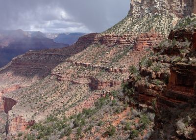
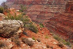
The Pennsylvanian to Lower Permian, (end of the Paleozoic Era), Supai Group, is a slope-forming section of red bed deposits found at the southwest-to-south Colorado Plateau. Cliff-forming interbeds (sandstone) are noticeable throughout the group, as well as the largest cliff-former the topmest member Esplanade Sandstone. The Supai Group is especially exposed throughout the Grand Canyon in northwest Arizona, as well as local regions of southwest Utah (Virgin River valley region). It outcrops southeastwards in Arizona at Chino Point (south Aubrey Valley), Sycamore Canyon, and famously at Sedona as parts of Oak Creek Canyon. In the Sedona region, it is overlain by the Hermit Formation, and the colorful Schnebly Hill Formation.
Contents
- Supai group
- Geology of the 4 member units
- Geologic sequence
- Supai Group and Hermosa Group coeval units
- References
The Supai Group is coeval with the Hermosa Group of east and south Utah; the Hermosa Group extended southeastwards from Utah to Durango, extreme southwest Colorado, and adjacent to the Hermosa type section.
Geology of the 4 member units
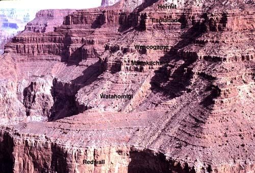
The oldest member (Early Pennsylvanian), the Watahomigi Formation is from sedimentary basins. It is composed of red mudstone, sandstone, and tan limestone. As ocean levels rose, basins filled, and the Manachka Formation was laid down (especially in the Grand Canyon). Continentally aeolian sand became more widespread; the coeval Weber Sandstone was deposited in northeast Utah (Dinosaur National Monument region, northeast of the Uncompahgre Uplift).
From Middle to Late Pennsylvanian, the Ancestral Rocky Mountains, the northeast spur from Colorado, (the Uncompahgre Uplift) became the source region for further continental river and stream deposits. Rising sea levels and erosion led to the deposition of the Wescogame Formation, (Grand Canyon) by Late Pennsylvanian time, and in east Utah, (Paradox Basin, southwest of Uncompahgre Uplift, the Honaker Trail Formation); northeast of the Uncompahgre Uplift, the Weber Sandstone continued deposition.
By Permian time, the Esplanade Sandstone (Supai Group member 4) was being laid down in northwest Arizona (Grand Canyon), and southwest Utah; the coeval Cedar Mesa Sandstone was being deposited in east Utah.
Geologic sequence
The geologic sequences of the coeval Supai and Hermosa Groups.
Geologic sequence
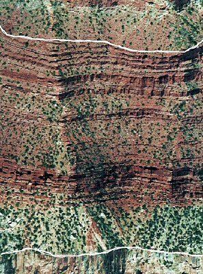
The Late Pennsylvanian-Early Permian geologic sequence of the Supai Group common in the Grand Canyon: The Pennsylvanian is the Late Carboniferous.
The Supai Group members were created from marine (oceanic) sequences of marine transgression, and regression, thus the alternating sandstone, siltsones, conglomerate subsections (facies); the subsections are not always a continuous transition into the above section, mostly due to ocean levels, falling, or rising, glaciation, or regional subsidence-(basins, etc.) or uplift of land. Today's Wasatch Front is the approximate lineage, NNE to SSW of the western coast region of North America from where the oceans transgressed. The ancient Antler Mountains-(Antler orogeny, off-shore volcanic island arch(es)), of ancient Nevada supplied material, from the west, off the 'ancestral' West Coast. The continent supplied material from the east, both directions supplying the offshore basin, the Cordilleran Basin which became part of the Basin and Range Province, in later epochs. Three other basins were involved in this history: southwest of the Ancestral Rocky Mountains was the Paradox Basin-(eastern Utah to Southwest Colorado), northeast was the Central Colorado Basin-(NW Colorado, NE Utah, SW Wyoming); the Oquirrh Basin was north-northwest, at present day northwest Utah.
Supai Group and Hermosa Group, coeval units
The coeval Supai and Hermosa Groups, Arizona, Utah, and northwest Colorado:
Because marine transgressions cover distances, over time, the coeval units are separated by distance, and type of deposition material; the local subsidence, or uplift, as well as glaciation, and sea level changes, can cause variations in the deposition sequences of transgression-regressions. The ocean was to the west of the proto-North American continent, but also northwest, or southwest.