
Country United States Incorporated 1630 Zip code 02472 Population 32,996 (2013) | State Massachusetts Settled 1630 Elevation 36 ft (11 m) Local time Sunday 7:24 AM | |
 | ||
Weather 3°C, Wind W at 11 km/h, 59% Humidity | ||
Community video tour of watertown massachusetts
The Town of Watertown is a city in Middlesex County, Massachusetts, United States. It is part of the Greater Boston area. The population was 31,915 at the 2010 census. Watertown is one of fourteen Massachusetts municipalities that have applied for, and been granted, city forms of government but wish to retain "The town of” in their official names.
Contents
- Community video tour of watertown massachusetts
- Map of Watertown MA USA
- Systematic house to house raids in locked down watertown massachusetts
- History
- Geography
- Demographics
- Armenian population
- Economy
- Transportation
- Education
- Notable people
- Politicians
- Sports
- Culture
- References
Map of Watertown, MA, USA
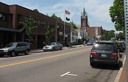
Watertown is made up of six neighborhoods: Bemis, Brigham (Brigham Historic District), Coolidge Square, East Watertown, Watertown Square and the West End.
Systematic house to house raids in locked down watertown massachusetts
History
Archeological evidence suggests that Watertown was inhabited for thousands of years before the arrival of settlers from England. Two tribes of Massachusett, the Pequossette and the Nonantum, had settlements on the banks of the river later called the Charles. The Pequossette built a fishing weir to trap herring at the site of the current Watertown Dam. The annual fish migration, as both alewife and blueback herring swim upstream from their adult home in the sea to spawn in the fresh water where they were hatched, still occurs every spring.
Watertown, first known as Saltonstall Plantation, was one of the earliest of the Massachusetts Bay settlements. It was begun early in 1630 by a group of settlers led by Richard Saltonstall and George Phillips and officially incorporated that same year. The alternate spelling "Waterton" is seen in some early documents.
The first buildings were upon land now included within the limits of Cambridge known as Gerry's Landing. For its first quarter century Watertown ranked next to Boston in population and area. Since then its limits have been greatly reduced. Thrice portions have been added to Cambridge, and it has contributed territory to form the new towns of Weston (1712), Waltham (1738), Lincoln (1754) and Belmont (1859). In 1632 the residents of Watertown protested against being compelled to pay a tax for the erection of a stockade fort at Cambridge; this was the first protest in America against taxation without representation and led to the establishment of representative democracy in the colony. As early as the close of the 17th century, Watertown was the chief horse and cattle market in New England and was known for its fertile gardens and fine estates. Here about 1632 was erected the first gristmill in the colony, and in 1662 one of the first woolen mills in America was built here.
The Massachusetts Provincial Congress, after adjournment from Concord, met from April to July 1775 in the First Parish Church, the site of which is marked by a monument. The Massachusetts General Court held its sessions here from 1775 to 1778. Committees met in the nearby Edmund Fowle House. Boston town meetings were held here during the siege of Boston, when many Boston families made their homes in the neighborhood. For several months early in the American Revolution the committees of safety and committee of correspondence made Watertown their headquarters and it was from here that General Joseph Warren set out for Bunker Hill.
From 1832 to 1834 Theodore Parker conducted a private school here and his name is still preserved in the Parker School, though the building no longer operates as a public school.
The Watertown Arsenal operated continuously as a military munitions and research facility from 1816 until 1995, when the Army sold the property, by then known as the Army Materials Technology Laboratory, to the town of Watertown. The Arsenal is notable for being the site of a 1911 strike prompted by the management methods of operations research pioneer Frederick Winslow Taylor (Taylor and 1911 Watertown Arsenal Strike). Taylor's method, which he dubbed "Scientific Management," broke tasks down into smaller components. Workers no longer completed whole items; instead, they were timed using stopwatches as they did small tasks repetitively, as Taylor attempted to find the balance of tasks that resulted in the maximum output from workers. The strike and its causes were controversial enough that they resulted in Congressional hearings in 1911; Congress passed a law in 1915 banning the method in government owned arsenals. Taylor's methods spread widely, influencing such industrialists as Henry Ford, and the idea is one of the underlying inspirations of the factory (assembly) line industrial method. The Watertown Arsenal was the site of a major superfund clean-up in the 1990s, and has now become a center for shopping, dining and the arts, with the opening of several restaurants and a new theatre. The site includes the Arsenal Center for the Arts, a regional arts center that opened in 2005. The Arsenal is now owned by athenahealth. Arsenal Street features two shopping malls across the street from one another, with the Watertown Mall on one side, and The Arsenal Project of Watertown (formerly the Arsenal Mall) on the other.
The Perkins School for the Blind, founded in 1829, has been located in Watertown since 1912.
The Stanley Brothers built the first of their steam-powered cars, which came to be known as Stanley Steamers, in Watertown in 1897.
In 1988, Watertown Square became the new location for the Armenian Library and Museum of America, said to host the largest collection of Armenian artifacts in North America.
Shortly after midnight of April 18–19, 2013, the two suspects in the Boston Marathon bombing engaged in a protracted battle with police, in Watertown involving the use of firearms and explosives. Tamerlan Tsarnaev was critically wounded and later pronounced dead and the town was completely locked down for hours as police, FBI, and Army National Guard personnel patrolled it, looking for the remaining suspect, Dzhokhar Tsarnaev, who was captured wounded but alive in a boat shortly after the lockdown ended on the following evening.
Geography
Watertown is located at 42°22′17″N 71°10′55″W (42.37139, -71.18194). To the north, it is bordered by the town of Belmont, along Belmont Street; to the south, it is bordered by Newton and Brighton - the border being largely formed by the Charles River. In Watertown Square, the nexus of the town, the town's border extends south of the Charles to encompass the neighborhood surrounding Casey Playground. To the east lies the City of Cambridge, the border to which is almost entirely the well-known Mount Auburn Cemetery, most of which is actually in Watertown (though commonly believed to be in Cambridge). To the west lies the more expansive city of Waltham, but there is no distinct geographic feature dividing the two municipalities.
According to the United States Census Bureau, the city has a total area of 4.2 square miles (11 km2), of which 4.1 square miles (11 km2) is land and 0.1 square miles (0.1 km² or 1.20%) is water.
Demographics
As of the census of 2000, there were 32,986 people, 14,629 households, and 7,329 families residing in the city. The population density was 8,025.7 people per square mile (3,098.8/km²). There were 15,008 housing units at an average density of 3,651.5 per square mile (1,409.9/km²). The racial makeup of the city was 91.42% White, 1.73% African American, 0.16% Native American, 3.87% Asian, 0.02% Pacific Islander, 0.85% from other races, and 1.95% from two or more races. Hispanic or Latino of any race were 2.68% of the population.
There were 14,629 households out of which 17.8% had children under the age of 18 living with them, 37.9% were married couples living together, 8.7% had a female householder with no husband present, and 49.9% were non-families. 34.1% of all households were made up of individuals and 12.4% had someone living alone who was 65 years of age or older. The average household size was 2.17 and the average family size was 2.86.
In the city, the population was spread out with 14.1% under the age of 18, 9.4% from 18 to 24, 39.8% from 25 to 44, 20.0% from 45 to 64, and 16.7% who were 65 years of age or older. The median age was 37 years. For every 100 females there were 86.1 males. For every 100 females age 18 and over, there were 83.8 males.
The median income for a household in the city was $59,764, and the median income for a family was $67,441. Males had a median income of $46,642 versus $39,840 for females. The per capita income for the city was $33,262. About 4.5% of families and 6.3% of the population were below the poverty line, including 8.6% of those under age 18 and 7.5% of those age 65 or over.
Armenian population
Watertown is a major center of the Armenian diaspora in the United States, with the third-largest Armenian community in the United States, estimated as numbering 7,000 to over 8,000 as of 2007. Watertown ranks only behind the California cities of Glendale and Fresno. Watertown is also the venue for the publication of long-running Armenian newspapers in English and Armenian, including:
Economy
Major employers based in Watertown include the Tufts Health Plan, the Perkins School for the Blind, Sasaki, Harvard Business Publishing, Bright Horizons Family Solutions and athenahealth.
Transportation
Watertown borders Soldiers Field Road and the Massachusetts Turnpike, major arteries into downtown Boston. Watertown is served by several MBTA bus and trackless trolley routes. Most of them pass through or terminate in Watertown Square or Watertown Yard. The former A-Watertown branch of the MBTA's Green Line ran to Watertown until 1969.
Education
Watertown Public Schools operates public schools in the city.