
Country United States County Middlesex Incorporated 1859 Area 12.2 km² Population 24,729 (2010) | State Massachusetts Settled 1636 Elevation 44 ft (13 m) Zip code 02478 Local time Thursday 12:15 PM | |
 | ||
Weather 3°C, Wind W at 45 km/h, 32% Humidity | ||
Video of 47 glendale road belmont massachusetts real estate homes
Belmont is a town in Middlesex County, Massachusetts, a suburb of Boston. It is part of the Boston metropolitan area. Its population was 24,729 at the 2010 census.
Contents
- Video of 47 glendale road belmont massachusetts real estate homes
- Map of Belmont MA USA
- History
- Railroad history
- Present day
- Geography
- Environmental concerns
- Demographics
- Foreign born population
- Points of interest
- Government
- Education
- Media
- Roads
- Public transit
- Health care
- Notable people
- Business
- Politics and government
- Arts and music
- Sports
- Literature
- Academics
- References
Map of Belmont, MA, USA
History
Belmont was established on March 10, 1859, by former citizens of, and land from the bordering towns of Watertown, to the south; Waltham, to the west; and Arlington, then known as West Cambridge, to the north. They also wanted a town where no one could buy or sell alcohol. Even today, a person cannot buy alcohol in this town. The town was named after Bellmont, the 200 acre (0.8 km²) estate of one of the leading and largest donor to its createion, John Perkins Cushing. Cushing Square is named after him and what was left of his estate after it nearly burned to the ground became a Belmont Public Library branch. The easternmost section of the town, including the western portion of Fresh Pond, was annexed by Camobridge in 1880 in a dispute over a slaughterhouse licensed in 1878 on Fresh Pond, so that Cambridge could protect Fresh Pond, a part of its municipal water system.
Preceding its incorporation, Belmont was an agrarian based town, with several large farms servicing Boston for produce and livestock. It remained largely the same until the turn of the twentieth century, when trolley service and better roads were introduced, making the town more attractive as a residential area, most notably for the building of large estates.
Belmont's population grew by over 90 percent during the 1920s.
The economics of the town shifted from purely agrarian to a commercial greenhouse base: much of the flower and vegetable needs of Boston were met from the Belmont 'hothouses' which persisted until about 1983 when Edgar's, the last large greenhouse firm in the area, closed. Other commercial enterprises in Belmont included mining and waste management. The reclamation of a large dump and quarry off Concord Avenue into sites for the Belmont High School and the Clay Pit Pond stands as a lasting example of environmental planning. With the introduction of automobiles and highways Belmont continued its transition to a commuter-based suburb throughout the twentieth century.
Belmont was the home of the headquarters of the John Birch Society from the organization's founding in 1958 until its relocation to Appleton, Wisconsin in 1989.
In 1963, English composer Arthur Bliss wrote The Belmont Variations based on the town of Belmont MA, where his wife Lady Trudy Bliss was born. The work was used at the Royal Albert Hall (London) as the test piece for the National Brass Band Championships of Great Britain.
The residents of Belmont did not have cable until 1989. They could only watch cable televisi be a department that is part of the town government. It would be called The Belmont Cable Department. As this had never been donw before by any Mass. town, the Town of Belmont had to get a special law passed by the Massachusetts legislature to makne this caple dept. possible. The local cable companies like Time Warner and Cablevision did not like this special law and spent most of the 1980s fighting the law tooth and nail. The cable companies won and in 1989, the cable system was set up by Time Warner. 3
In 1993, this small suburban was overwhelmed by Japanese tourists. Crown Prince of Japan had just become engaged to Masako Owada, the future Crown Princess of Japan. Her parents were part of the Japanese diplomatic service and they had lived in Belmont in the early 1980s. She graduated from Belmont High School. The Japanese tourists came to see the house where she had lived and the local schools she attended. This is probably the only time that this small town had ever been mentioned in newspapers throughout the world.
Railroad history
Belmont was once served by two railroads, the Fitchburg Railroad and the Central Massachusetts Railroad, both of which were later to become part of the Boston & Maine Railroad system. Originally the two railroads had their own tracks through town, but in 1952 the Central Mass tracks were lifted between Hill's Crossing and Clematis Brook (Waltham). Traffic was then rerouted over the Fitchburg line.
Today the MBTA owns the trackage that runs through Belmont. It is known as the Fitchburg Line. Passenger service on this line currently ends at Fitchburg, but it once was the area's main route into New York state. As of 2011, the MBTA was planning to extend future service to West Fitchburg.
The station stops at Belmont Center and Waverley were once grade crossings, meaning pedestrian and vehicular traffic had to cross directly over rails that were in public roads. In 1907 the grade at Belmont Center was eliminated by constructing a stone bridge to carry the tracks past a new station building. At Waverley, the grade was lowered so that the tracks ran under Trapelo Road.
A second railroad station building exists in Belmont, though it is not obvious. The Wellington Hill Station was originally built in the 1840s as a private school, not far from its current location in Belmont Center. It was then used by the Fitchburg Railroad from 1852 to 1879. When the railroad decided to replace the station with a larger structure, the building was moved to the Underwood Estate and used as a summer house. In 1974, the station was donated to the Belmont Historical Society. It was restored and relocated to its current location in 1980.
Present day
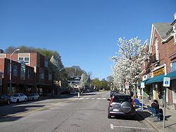
Belmont remains a primarily residential suburb with little growth since the 1950s. It is best known for the mansion-filled Belmont Hill neighborhood, although most residents live in more densely settled, low-lying areas around the Hill. There are three major commercial centers in the town: Belmont Center in the center, Cushing Square in the south, and Waverley Square in the west. Town Hall and other civic buildings are located in Belmont Center. Large tracts of land from former farms and greenhouse estates form public or publicly accessible areas such as Rock Meadow, Habitat (Mass Audubon), portions of the McLean Hospital tract and various town fields.
Geography
According to the United States Census Bureau, the town has a total area of 4.7 square miles (12.2 km²), of which 4.7 square miles (12.1 km²) is land and 0.1 square miles (0.1 km²), or 1.06%, is water.
Belmont is bordered by Cambridge on the east, Arlington on the north, Lexington on the northwest, Waltham on the west, and Watertown on the south.
Environmental concerns
In 2002, Middlesex County was ranked in the worst 10% of polluted counties in the United States in terms of air and water pollution. Two companies that ranked in the top 10 for polluters in the county were Cambridge Plating Company in Belmont and the Polaroid Corporation in Waltham.
The chemicals released were trichloroethylene and dichloromethane, both of which are harmful and have been shown to cause cancer. These chemicals are released into the air so it is difficult to trace them and to determine the source as there are also several other industries in the area that release the same pollutants. It is estimated that 3% of homes in Belmont are at risk of having lead hazards.
In 2004, the town of Belmont first hosted an annual community environmental fair to encourage environmentally friendly behavior for its residents.
Demographics
As of the census of 2010, there were 24,729 people. The 2010 census lists 10,184 housing units. The population density was 5,316.9 people per square mile (2,004.6/km²). The racial make up of the town was 83.5% White, 1.8% Black or African American, 0.1% Native American, 11.1% Asian, and 2.7% from two or more races. Hispanic or Latino of any race were 3.0% of the population. 6.3% of the population are under the age of five, 24.6% are under the age of eighteen, and 15.8% are 65 years of age or older; 53% are female. The median household income was $95,377.
The 2000 census listed 9,732 households out of which 31.0% had children under the age of 18 living with them, 54.9% were married couples living together, 8.8% had a female householder with no husband present, and 33.7% were non-families. 25.9% of all households were made up of individuals and 11.9% had someone living alone who was 65 years of age or older. The average household size was 2.45 and the average family size was 3.01.
Foreign-born population
In 2010, 20% of the residents of Belmont were born outside of the United States. In 2000 this percentage was 15%.
Points of interest
Government
The executive branch of the town government consists of a three-person Board of Selectmen elected by the residents. The Selectmen appoint a Town Administrator who is in charge of daily operations.
The legislative branch is a representative town meeting, with eight districts each electing 36 representatives, plus ex-officio members and a Town Moderator to run the annual meeting.
Belmont is part of the 24th Middlesex District (for the Massachusetts House of Representatives), the 2nd Middlesex and Suffolk District (for the Massachusetts Senate), and Massachusetts's 5th congressional district (for the United States House of Representatives).
Education
Belmont is served by the Belmont Public Schools, governed by an independently elected school committee.
There are four public elementary schools in Belmont, the Mary Lee Burbank, Daniel Butler, Winn Brook, and Roger Wellington schools. The Mary Lee Burbank School was founded in 1931. Two other public elementary schools, Payson Park and Kendall, were closed in the 1970s and 1980s, respectively. The former closed after being destroyed by fire, the latter closed due to population shifts and was converted to an arts center, which was later also destroyed by fire. There is one public middle school, the Winthrop L. Chenery Middle School, which was rebuilt on the same location after an electrical fire damaged the auditorium in 1995, and one public high school, Belmont High School.
Belmont High is noted for its college placement, strong athletics, academics, music, and theater arts; a typical class size of about 290 students; and average SATs for the class of 2004 of 1179. Belmont students also have the option to attend Minuteman Career and Technical High School in Lexington. Minuteman High also offers adult education courses. In 2009, U.S. News & World Report gave Belmont High School a gold medal and named it the 100th best non-private high school in the United States and the second best in the state of Massachusetts (after Boston Latin School).
Belmont Hill School is a private, non-sectarian high school, grades 7-12. Belmont Day School is a private, non-sectarian PK-8 school. There are several smaller private schools.
Lexington Chinese School holds classes at Belmont High on Sundays. In 2003, over 400 students attended.
Media
The Belmont Citizen-Herald is a newspaper covering Belmont since 1988. The print edition of the newspaper is available in stores on Thursday. The Citizen-Herald was actually two newspapers at one time. The Belmont Citizen began publishing in 1920, and the Belmont Herald started in 1930. The Boston Globe and Boston.com publish a Belmont Your Town website that provides local news and information. Belmont Patch and The Belmontonian provides online news.
Roads
Major roads in the town are Concord Avenue, which bisects the town from east to west, Common Street and Pleasant Street (Route 60) which travel north-south through Belmont, and Trapelo Road and Belmont Street which run along the southern edge of the town. Massachusetts Route 2 runs along the northern border of the town.
Belmont is served directly by two state routes. Running close to the middle of town is Route 60, locally known as Pleasant Street. On the northern border, Route 2 predominantly outlines Belmont's boundary with the neighboring town of Arlington. Despite the smallness of the town, Belmont has 5 exits on Route 2. Her nearby major routes include I-95/MA-Route 128, Route 16, Route 3, and Route 20.t h
Public transit
Belmont is served by the Massachusetts Bay Transportation Authority's Fitchburg Commuter Rail line and its bus lines.
Two rail stations—Waverley and Belmont Center on the MBTA Commuter Rail—are located in the town. Belmont is roughly sixteen minutes away from the rail line's terminus at North Station, Boston.
Nearby in Cambridge lies Alewife Station, the western terminus of the Red Line; providing a connection to Boston and the entire metropolitan rapid transit system. Belmont residents bike or take their cars to get to this station. There are laos taxis avaiable to take a person home.
Health care
Located in Belmont is McLean Hospital, a psychiatric hospital and research center. It is also the largest landowner in town and is also featured in the movie called Girl Inerrupted.
Notable people
Due to its proximity to Harvard and MIT universities, amongst others, Belmont has had several Nobel Prize winners in residence at one time or another. Notable past and present residents include: