
Elevation 0–716 m (0–2,350 ft) | Time zone ET (UTC-5) | |
 | ||
Principal municipalities Washington, Arlington, Alexandria | ||
The Washington metropolitan area is the metropolitan area centered on Washington, D.C., the capital of the United States. The area includes all of the federal district and parts of the U.S. states of Maryland and Virginia, along with a small portion of West Virginia.
Contents
- Nomenclature
- Composition
- Political subdivisions
- District of Columbia
- Maryland
- Virginia
- West Virginia
- Metropolitan Washington Council of Governments
- Principal cities
- Politics
- Racial composition
- Social indicators
- Economy
- Real estate and housing market
- Net worth wealth disparities and business ownership
- Primary industries
- Largest companies
- History
- Transportation
- Major airports
- Rail transit systems
- Bus transit systems
- Bicycle sharing systems
- Sports teams
- Media
- Area codes
- References
The Washington metropolitan area is one of the most educated and most affluent metropolitan areas in the United States. The metro area anchors the southern end of the densely populated Northeast megalopolis, with an estimated total population of 6,097,684 as of the 2014 U.S. Census Bureau estimate, making it the sixth-largest metropolitan area in the country and largest metropolitan area in the Census Bureau's Southeast region.
Nomenclature
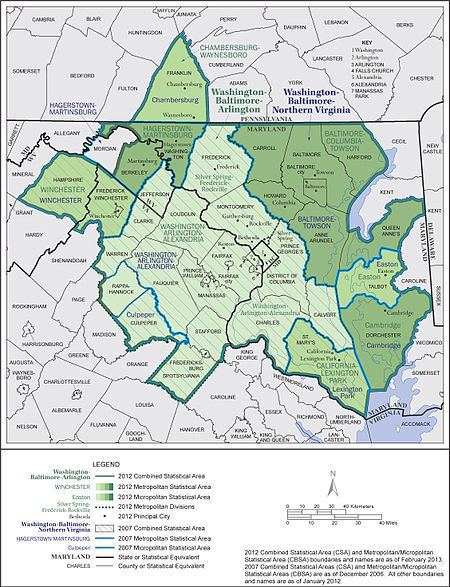
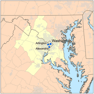
The U.S. Office of Management and Budget defines the area as the Washington–Arlington–Alexandria, DC–VA–MD–WV metropolitan statistical area, a metropolitan statistical area used for statistical purposes by the United States Census Bureau and other agencies. The region's three largest cities are the federal territory of Washington, D.C., the county (and Census-designated place) of Arlington, and the independent city of Alexandria. The Office of Management and Budget also includes the metropolitan statistical area as part of the larger Baltimore–Washington metropolitan area, which has a population of 9,546,579 as of the 2014 Census Estimate.
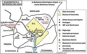
The area is also sometimes referred to as the National Capital Region, particularly by federal agencies such as the military Department of Homeland Security. Another term used to describe the region is the D.C. Area. The area is increasingly referred to as the DMV, a shorthand for the District of Columbia, Maryland, and Virginia. The area in the region that is surrounded by Interstate 495 is also referred to as being "inside the Beltway". The city of Washington, which is at the center of the area, is referred to as "the District" because it is the federal District of Columbia, and is not part of any state. The Virginian portion of the region is known as Northern Virginia.
Composition
The U.S. Census Bureau divides the Washington statistical metropolitan area into two metropolitan divisions:
Political subdivisions
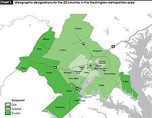
The area includes the following counties, districts, and independent cities:
District of Columbia
Maryland
Virginia
West Virginia
Metropolitan Washington Council of Governments
Founded in 1957, the Metropolitan Washington Council of Governments (MWCOG) is a regional organization of 21 Washington-area local governments, as well as area members of the Maryland and Virginia state legislatures, the U.S. Senate, and the U.S. House of Representatives. MWCOG provides a forum for discussion and the development of regional responses to issues regarding the environment, transportation, public safety, homeland security, affordable housing, community planning, and economic development.
The National Capital Region Transportation Planning Board, a component of MWCOG, is the federally designated metropolitan planning organization for the metropolitan Washington area.
Principal cities
The metropolitan area includes the following principal cities (not all of which are incorporated as cities; one, Arlington, is actually a county, and another, Bethesda, is not a city, simply a census-designated unincorporated area.
Politics
The relative strength of the major political parties within the region is shown by the presidential election results since 1960, as presented in the adjacent table.
Racial composition
The area has been a magnet for international immigration since the late 1960s. It is also a magnet for internal migration (persons moving from one region of the U.S. to another). Census estimates show that persons of post-1965 immigrant stock will likely represent 25% of the region's population by 2010, forming a bigger population bloc than native blacks for the first time.
Racial composition of the Washington, D.C. area:
Social indicators
The Washington metropolitan area has ranked as the highest-educated metropolitan area in the nation for four decades. As of the 2006–2008 American Community Survey, the three most educated places with 200,000 people or more in Washington–Arlington–Alexandria by bachelor's degree attainment (population 25 and over) are Arlington, Virginia (68.0%), Fairfax County, Virginia (58.8%), and Montgomery County, Maryland (56.4%). Forbes magazine stated in its 2008 "America's Best- And Worst-Educated Cities" report: "The D.C. area is less than half the size of L.A., but both cities have around 100,000 Ph.D.'s."
The Washington, D.C. metro area has held the top spot in the American College of Sports Medicine's annual American Fitness Index ranking of the United States' 50 most populous metropolitan areas for two years running. The report cites, among other things, the high average fitness level and healthy eating habits of residents, the widespread availability of health care and facilities such as swimming pools, tennis courts, and parks, low rates of obesity and tobacco use relative to the national average, and the high median household income as contributors to the city's community health.
In the 21st century, the Washington metropolitan area has overtaken the San Francisco Bay Area as the highest-income metropolitan area in the nation. The median household income of the region is US$72,800. The two highest median household income counties in the nation – Loudoun and Fairfax County, Virginia – are components of the MSA (and #3 is Howard County, officially in Baltimore's sphere but strongly connected with Washington's); measured in this way, Alexandria ranks 10th among municipalities in the region – 11th if Howard is included – and 23rd in the entire United States. 12.2% of Northern Virginia's 881,136 households, 8.5% of suburban Maryland's 799,300 households, and 8.2% of Washington's 249,805 households have an annual income in excess of $200,000, compared to 3.7% nationally.
According to a report by the American Human Development Project, women in the Washington metropolitan area are ranked as having the highest income and educational attainment among the 25 most populous metropolitan areas in the nation, while Asian American women in the region had the highest life expectancy, at 92.3 years.
Economy
The Washington, D.C. area has the largest science and engineering work force of any metropolitan area in the nation in 2006 according to the Greater Washington Initiative at 324,530, ahead of the combined San Francisco Bay Area work force of 214,500, and Chicago metropolitan area at 203,090, citing data from U.S. Census Bureau, the Bureau of Labor Statistics, Claritas Inc., and other sources.
The Washington, D.C. area was ranked as the second best High-Tech Center in a statistical analysis of the top 100 Metropolitan areas in the United States by American City Business Journals in May 2009, behind the Silicon Valley and ahead of the Boston metropolitan area. Fueling the metropolitan area's ranking was the reported 241,264 tech jobs in the region, a total eclipsed only by New York, Los Angeles, and the combined San Jose–San Francisco–Oakland regions, as well as the highest master's or doctoral degree attainment among the 100 ranked metropolitan areas. A Dice.com report showed that the Washington–Baltimore area had the second-highest number of tech jobs listed: 8,289, after the New York metro area with 9,195 jobs.
Real estate and housing market
Changes in house prices for the D.C. area are publicly tracked on a regular basis using the Case–Shiller index; the statistic is published by Standard & Poor's and is also a component of S&P's 10-city composite index of the value of the U.S. residential real estate market.
McLean ZIP code 22102 had the highest median home prices among ZIP codes within the Washington metropolitan area as of 2013.
Net worth, wealth disparities, and business ownership
The economy of the Washington metropolitan region is characterized by significant wealth disparities, which were heightened by the Great Recession and the 2007-09 housing crisis, which adversely affected black and Hispanic households more than other households.
A 2016 Urban Institute report found that the median net worth (i.e., assets minus debt) for white households in the D.C. region was $284,000, while the median net worth for Hispanic/Latino households was $13,000, and for African American households as $3,500. Asian Americans had the highest median net worth in the Washington area ($220,000 for Chinese American households, $430,000 for Vietnamese American households, $496,000 for Korean American households, and $573,000 for Indian American households).
Although the median net worth for white D.C.-area households was 81 times that of black D.C.-area households, the two groups had comparable rates of business ownership (about 9%). The Urban Institute report suggests that this "may be driven by the presence of a large federal government and a local district government whose membership and constituents have been largely Black, coupled with government policies designed to increase contracting opportunities for minority-owned businesses."
Primary industries
Biotechnology
The Washington metropolitan area has a significant biotechnology industry; companies with a major presence in the region as of 2011 include Merck, Pfizer, Human Genome Sciences, Martek Biosciences, MedImmune and Qiagen.
Defense contracting
Many defense contractors are based in the region to be close to the Pentagon in Arlington. Local defense contractors include Lockheed Martin, the largest, as well as Raytheon, General Dynamics, BAE Systems, Northrup Grumman, Computer Sciences Corporation (CSC), Science Applications International Corporation (SAIC), CACI, and Orbital Sciences Corporation.
Tourism
Tourism is a significant industry in the Washington metropolitan region. In 2015, more than 74,000 tourism-sector jobs existed in the District of Columbia, a record-setting 19.3 million domestic tourists visited the city, and domestic and international tourists combined spent $7.1 billion. The convention industry is also significant; in 2016, D.C. hosted fifteen "city-wide conventions" with an estimated total economic impact of $277.9 million.
Tourism is also significant outside the District of Columbia; in 2015, a record-setting $3.06 billion in tourism spending was reported in Arlington, Virginia, and $2.9 million in Fairfax County, Virginia. A 2016 National Park Service report estimated that there were 56 million visitors to national parks in the National Capital Region, sustaining 16,917 and generating close to $1.6 billion in economy impact.
Largest companies
The following Fortune 500 companies are headquartered in the region:
History
The 2005 Base Realignment and Closure resulted in a significant shuffling of military, civilian, and defense contractor employees in the Washington D.C. area. The largest individual site impacts of the time are as follows:
BRAC 2005 was the largest infrastructure expansion by the Army Corps of Engineers since World War II, resulting in the Mark Center, tallest building they have ever constructed, as well as National Geospatial-Intelligence Agency Campus East, which at 2.4 million square feet is the largest building the Corps have constructed since the Pentagon.
Transportation
'WMATA'-indicated systems are run by Washington Metropolitan Area Transit Authority and always accept Washington Metro fare cards, others may or may not.
Major airports
Rail transit systems
Bus transit systems
Bicycle sharing systems
Sports teams
Listing of the professional sports teams in the Washington metropolitan area:
Media
The Washington metropolitan area is home to USA Today, C-SPAN, PBS, NPR, POLITICO, BET, TV One and Discovery Communications. The two main newspapers are The Washington Post and The Washington Times. Local television channels include WRC-TV 4 (NBC), WTTG 5 (FOX), WJLA 7 (ABC), WUSA 9 (CBS), WDCA 20 (MyNetworkTV), WETA-TV 26 (PBS), WDCW 50 (CW), and WPXW 66 (Ion). NewsChannel 8 is a 24/7 local news provider available only to cable subscribers. Radio stations serving the area include: WETA-FM, WIHT, WMAL-AM, and WTOP.