
Primary inflows Surface elevation 1,197 m Length 1,974 m Area 142 ha Primary outflow Walupt Creek | Primary outflows Walupt Creek Max depth 91 m Max width 1,262 m Shore length 5.5 km | |
 | ||
Catchment area 13.7 square miles (35 km) | ||
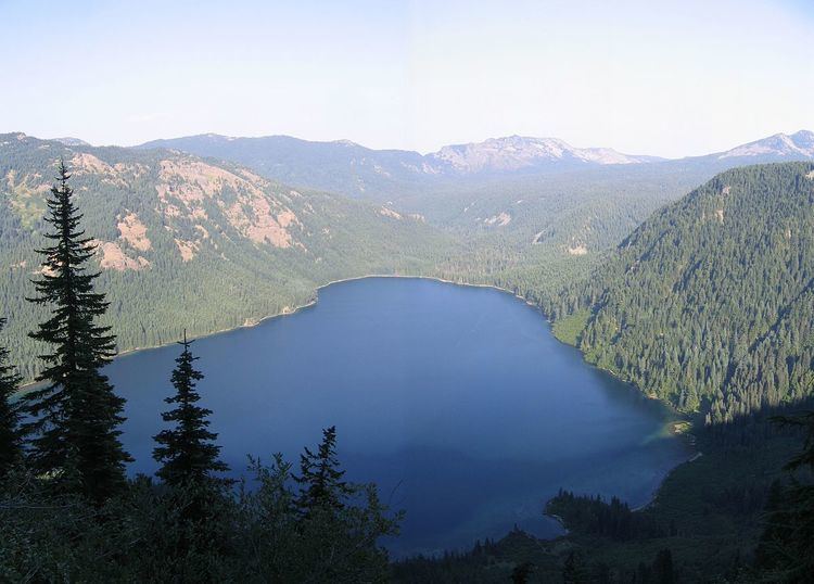
Walupt Lake is a large freshwater lake located in the Gifford Pinchot National Forest in the Cascade Mountains of Washington. It is located near the town of Packwood and is popular for camping, boating, and hiking. The eastern half of the lake is within the Goat Rocks Wilderness. It is the deepest and second largest natural lake in Lewis County.
Contents
Map of Walupt Lake, Washington 98377, USA
Hydrology
Walupt Lake is ribbon lake situated near the end of a long glacial valley. The main inflow of Walupt Lake is the perennial, snowmelt-fed Walupt Creek, which flows out of this long valley into the east end of the lake. Other small streamlets flow into the lake from the steep valley walls above. The lake's watershed encompasses 13.7 square miles (35 km2) of land in the southern Goat Rocks with the majority of this watershed being forested or unproductive and the rest being the lake itself. The outflow, Walupt Creek, is on the northwestern corner of the lake. Walupt Lake is vaguely boot-shaped with the toe pointed to the east, up the valley. The widest part of the lake is on the western end at 4,140 feet (1,260 m) and the longest part is the southern third at 6,475 feet (1,974 m). Walupt Lake has an area of 350 acres (140 ha) with an average depth of 180 feet (55 m). The lake is the deepest lake in Lewis County and is also one of the deepest in Washington with a maximum depth of 300 feet (91 m). The great average depth gives the lake its large volume of 62,000 acre feet (76,000,000 m3) of water, putting it among the top 25 lakes in Washington by volume.
History
The name Walupt is of Yakama origin. It was given to the lake by Albert Hale Sylvester. Even though it was a large lake, it did not appear on any older maps and he had not heard of it. While he was working on the ridge above the lake, he encountered a Native American who told him that Walupt was what the region was called by the Yakamas, so Sylvester applied the name to the lake. The Indian also related a legend of the lake to Sylvester. A great Yakama hunter pursued a mighty deer for many days, until finally the deer led him to the lake. The deer jumped in, swam around for a while, and then disappeared. Since then, any hunter whose chase leads to the lake will sometimes see the deer swimming in the lake.
Recreation
The eastern half of Walupt Lake is within the Goat Rocks Wilderness of the Gifford Pinchot National Forest. Walupt Lake Campground is a popular campground and day use area on the west end of the lake with 42 primitive sites and a boat ramp. The campground is also a popular access point for the Goat Rocks Wilderness. While very little of the surrounding countryside is visible from the lake, once on the ridges above the lake, there are up close views of the surrounding Goat Rocks, Mount Adams off to the south and Mount Rainier to the northwest. The Nannie Ridge Trail #98 and Walupt Lake Trail #101 both start at the eastern end of the campground and provide different views of the wilderness and surrounding area on the way to their respective junctions with the Pacific Crest National Scenic Trail.