
Existed: 1933 – present Length 117.1 km | East end: SR 400 in Alexandria Constructed 1933 | |
 | ||
Counties | ||
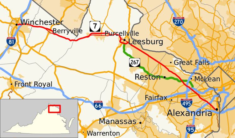
State Route 7 (SR 7) is a major primary state highway and busy commuter route in northern Virginia, United States. It travels southeast from downtown Winchester to SR 400 (Washington Street) in downtown Alexandria. Its route largely parallels those of the Washington & Old Dominion Trail (W&OD Trail) and the Potomac River. West of I-395, SR 7 is part of the National Highway System.
Contents
- Map of VA 7 Virginia USA
- Route description
- Planned
- Berryville business route
- Purcellville business route
- Leesburg business route
- References
Map of VA-7, Virginia, USA
Route description
SR 7 begins downtown in the independent city of Winchester, as East Piccadilly Street at an intersection with US Route 11 (US 11) and US 522, and it continues through the east end of the city, along North East Lane, National Avenue, and finally Berryville Avenue. SR 7 exits the city into surrounding Frederick County, where its name changes to Berryville Pike and it becomes a four-lane highway. SR 7 continues across Interstate 81 (I-81) and then into Clarke County.
SR 7 enters Clarke County from Frederick County, crossing Opequon Creek, and continues towards the town of Berryville. Business SR 7 (SR 7 Bus.) splits off just west of Berryville and passes through the town, while the main route bypasses the town to the north. Both routes cross US 340, and SR 7 Bus. rejoins SR 7 just east of the town. SR 7 crosses the Shenandoah River and its name changes to the Harry Flood Byrd Highway. SR 7 crosses the Loudoun–Clarke county line and the Appalachian Trail at the summit of Snickers Gap in the Blue Ridge Mountains.
SR 7 enters the rural western part of Loudoun County as the Harry Flood Byrd Highway at Snickers Gap, and then it descends out of the Blue Ridge Mountains. It crosses the Snickersville Turnpike, and then it passes through the village of Bluemont (formerly Snickersville). Next SR 7 curves just south of Jefferson County, West Virginia.
SR 7 becomes a divided, limited-access highway with a speed limit of 55 mph (89 km/h) just west of the town of Round Hill, where another SR 7 Bus. splits off to serve the towns of Round Hill, Purcellville, and Hamilton, while the main road runs outside of the towns as a bypass. SR 7 Bus. rejoins the main road at the interchange with SR 9 in Paeonian Springs.
SR 7 continues towards the well-developed eastern half of Loudoun County as a four-lane divided highway with some at-grade intersections, and it passes through Clarke's Gap in Catoctin Mountain. Another SR 7 Bus. splits off on the western side of the town of Leesburg, the county seat of Loudoun County. The main road continues as the Leesburg Bypass, and merges with the bypass of US 15 around the southern side of Leesburg, while the business route passes through town as Market Street. SR 7 intersects with US 15 Bus. (King Street) by the county courthouse in the center of Leesburg.
The Virginia Department of Transportation (VDOT) has plans to widen the section of SR 7 between SR 9 and East Market Street. However, due to highway budget restrictions, this project was put on hold in June 2008. As of December 2014, construction had begun on the widening of this section of SR 7. In addition to widening Westbound SR 7 from two to three lanes, the median will be modified to limit left turns into and out of Roxbury Hall Road, Leeland Orchard Road, Fort Johnston Road, White Gate Place, and Beechnut Place. In addition to the work on SR 7, roundabouts will be installed at the interchange between SR 7 and SR 9. The southern roundabout will combine the separate intersections of the on and off ramps from SR 7 and Colonial Highway/Dry Mill Road into one.
The SR 7 bypass crosses the Washington & Old Dominion Trail just before the US 15 bypass splits off from SR 7 in eastern Leesburg, and then SR 7 Bus. rejoins the main highway near the same location. SR 7 continues on through the eastern half of Leesburg, with six lanes. It then crosses Goose Creek, and passes through Ashburn.
SR 7 has been planned to be rebuilt as a controlled-access highway through eastern Loudoun County. To accomplish this, highway interchanges would be constructed to replace the ordinary intersections at Belmont Ridge Road, Loudoun County Parkway, and Ashburn Village Boulevard. A new overpass was constructed to carry Sycolin Road across SR 7 in Leesburg, which opened to traffic on August 11, 2014. The plans include building more overpasses at Lexington Drive and Riverside Parkway, both in Ashburn. Construction is to begin October 2015 on the Belmont Ridge Road intersection. An additional interchange is planned at Battlefield Parkway in Leesburg.
SR 7 passes by numerous housing subdivisions and businesses before it reaches an interchange with SR 28, close to the Fairfax County line in Sterling.
SR 7 is named Leesburg Pike all the way across Fairfax County, where it is mainly a suburban route. It enters Fairfax County at the interchange with the Fairfax County Parkway (SR 286) and Algonkian Parkway. It continues through Fairfax County, passing by subdivisions and strip malls. It passes through Tysons Corner, where it intersects SR 123 and SR 267, the Dulles Access and Toll Roads. It then intersects the Capital Beltway (I-495) in McLean and intersects I-66 a half mile (0.8 km) west of the West Falls Church Metro station.
SR 7 then enters the independent city of Falls Church and becomes Broad Street and marks the north/south division for city streets. The road intersects US 29 in the city's center and crosses the W&OD Trail in the city's west end. SR 7 then re-enters Fairfax County as Leesburg Pike and passes through Seven Corners, named for the five roads that intersect, including SR 338 (Hillwood Avenue) and US 50 (Arlington Boulevard), which is grade separated from the rest of the intersection. From there, it travels to Bailey's Crossroads, where it intersects SR 244 (Columbia Pike).
SR 7 enters the City of Alexandria from Fairfax County and briefly forms the border between the Alexandria and Arlington County, and then intersects I- 395. It continues as King Street through Alexandria, passing by T. C. Williams High School, George Washington Masonic National Memorial, Union Station (Amtrak and Virginia Railway Express), and the King Street – Old Town Metro station. SR 7 ends at the intersection of King Street and SR 400 (Washington Street) in Old Town Alexandria, one quarter of a mile (0.4 km) west of the Potomac River.
Planned
Frederick County
Clarke County
Fairfax County
Berryville business route
State Route 7 Business (SR 7 Bus.) is a business route in the U.S. state of Virginia. It follows Main Street through downtown Berryville.
Purcellville business route
State Route 7 Business (SR 7 Bus.) is a business route in the U.S. state of Virginia. It runs 9.28 miles (14.93 km) from SR 7 in Round Hill to SR 9 in Leesburg, where the roadway continues east and south as SR 699. The route provides access from the main route, SR 7, to Purcellville. The route has multiple names along its length including Loudoun Street, Main Street, and Colonial Highway. The route was formed in two segments. The first one was formed in 1980, and the second one was formed in 1987.
The route's western end is at its parent route, SR 7. It then intersects New Cut Road and Main Street, both part of SR 719. It meets SR 7 once again at a diamond interchange. After that, the route meets State Route 287 (SR 287) at a roundabout. The route's eastern end is at State Route 9 (SR 9) (Charles Town Pike), where it goes east and south as SR 699 (Dry Mill Rd.).
The first segment of the route was commissioned in 1980 between SR 287 and SR 9. The second segment of the route was commissioned in 1987 between SR 287 and SR 7. These segments were both built along the former alignment of its parent route, SR 7.
Leesburg business route
State Route 7 Business (SR 7 Bus.) in downtown Leesburg is a very narrow two-laned street, but towards its eastern terminus, it widens and becomes multilane.