
State Virginia Elevation 341 ft (104 m) ZIP codes 20175-20178 Population 47,673 (2013) | County Loudoun Time zone Eastern (EST) (UTC-5) Local time Tuesday 6:18 PM | |
 | ||
Country United States of America Weather 1°C, Wind NW at 47 km/h, 62% Humidity Points of interest Morven Park, The Marshall House, Ida Lee Park Recreatio, Ball’s Bluff Battlefield Regional, Olde Izaak Walton Park | ||
Leesburg is a historic town within and the county seat of Loudoun County, Virginia. Leesburg is located 33 miles (53 km) west-northwest of Washington, D.C. along the base of Catoctin Mountain and adjacent to the Potomac River. Its population according to the 2010 Census is 42,616. The town is also the northwestern terminus of the Dulles Greenway, a private toll road that connects to the Dulles Toll Road at Washington Dulles International Airport.
Contents
- Map of Leesburg VA USA
- Etymology
- History
- Historic sites
- Symbol
- Geography
- Demographics
- Education and public services
- Newspapers and radio stations
- Business and industry
- Top employers
- Parks
- Events
- Notable people
- References
Map of Leesburg, VA, USA
Leesburg, like the rest of Loudoun, has undergone considerable growth and development over the last 30 years, transforming from a small, rural, piedmont town to a suburban bedroom community for commuters to the national capital. Current growth in the town and its immediate area to the east (Lansdowne/Ashburn) concentrates along the Dulles Greenway and State Route 7, which roughly parallels the Potomac River between Winchester to the west and Alexandria to the east.
The Federal Aviation Administration's Washington Air Route Traffic Control Center is located in Leesburg.
Etymology
Leesburg was named to honor the influential Thomas Lee and not, as is popular belief, his son Francis Lightfoot Lee who lived in Loudoun and brought up the bill to establish Leesburg, nor as is sometimes thought, Robert E. Lee (his great-grandnephew).
History
Prior to European settlement, the area around Leesburg was occupied by various Native American tribes. John Lederer (1670) testified that the entire Piedmont region had once been occupied by the "Tacci, alias Dogi", but that the Siouan tribes, driven from the northwest, had occupied it for 400 years. In 1699, the Algonquian Piscataway (Conoy) moved to an island in the Potomac in the environs of Leesburg, and were there when the first known Europeans visited what is now Loudoun.
What would become known as the Old Carolina Road (present day U.S. Route 15) was a major route of travel between north and south for Native tribes. According to local historians, a pitched battle was fought near present Leesburg between the warring Catawba and Lenape tribes, neither of whom lived in the area. A war party of Lenape had traveled from their home in New Jersey and neighboring regions, all the way to South Carolina to inflict a blow on their distant enemies, the Catawba. As they were returning northward, a party of Catawbas overtook them before they reached the Potomac, but were defeated in a pitched battle two miles (3 km) south of Leesburg. The surviving Lenape buried their dead in a huge burial mound, and early settlers reported that they would return to this mound to honor their dead on the anniversary of this battle for many years thereafter. The date of this conflict is unknown, but it seems the Lenape and Catawba were indeed at war in the 1720s and 1730s.
European settlement of near Leesburg began in the late 1730s as tidewater planters moved into the area from the south and east establishing large farms and plantations. Many of the First Families of Virginia were among those to settle in the area including the Carters, Lees and Masons. The genesis of Leesburg occurred sometime before 1755 when Nicholas Minor acquired land around the intersection of the Old Carolina Road and the Potomac Ridge Road (present day Route 7) and established a tavern there. Despite lack of growth around the tavern, upon Loudoun's formation in 1757, Minor dubbed the sparse collection of buildings about his tavern "George Town" in honor of the reigning monarch of Great Britain. The village's prosperity changed the following year when the British Colonial Council ordered the establishment of the county Court House at the crossroads. Accordingly, Minor had a town laid out on the traditional Virginia plan of six criss-cross streets. On October 12 of that year (1758) the Virginia General Assembly founded the town of Leesburg upon the 60 acres (0.24 km2) that Minor laid out. Leesburg was renamed to honor the influential Thomas Lee and not, as is popular belief, his son Francis Lightfoot Lee who lived in Loudoun and brought up the bill to establish Leesburg, nor as is sometimes thought, Robert E. Lee (his great-grandnephew). When the post office was established in Leesburg in 1803 the branch was named "Leesburgh"; the 'h' persisted until 1894.
During the War of 1812, Leesburg served as a temporary haven for the United States Government and its archives (including the Declaration of Independence and the U.S. Constitution and portraits of early American leaders like Benjamin Franklin) when it was forced to flee Washington, D.C. in the face of the British Army. When reconstruction began on the Capitol, Potomac Marble from quarries just south of Leesburg was used.
Early in the American Civil War Leesburg was the site of the Battle of Balls Bluff, a resounding Confederate victory. The battlefield is marked by one of America's smallest national cemeteries. The town frequently changed hands over the course of the war as both armies traversed the area during the Maryland and Gettysburg campaigns. The Battle of Mile Hill was fought just north of the town prior to its occupation by Robert E. Lee in September 1862. Leesburg also served as a base of operations for Col. John S. Mosby and his partisan Raiders, for whom the Loudoun County High School mascot is named (the Raiders). Some people consider the local courthouse among the few courthouses in Virginia not burned during the Civil War (1861–1865); though it was not built until 1894.
In the 20th century, Leesburg was the home of World War II General George C. Marshall, architect of the famous Marshall Plan that helped re-build Europe after the war, and radio personality Arthur Godfrey, who donated land for the town's first airport.
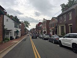
Today Leesburg continues to serve as the center of government and commerce for Loudoun County. The town's Historic District was placed on the National Register of Historic Places in 1970 and cited as one of the best preserved and most picturesque downtowns in Virginia. Downtown merchants have recently labeled themselves "Loudoun's (or, Loudoun County's, depending on the audience) Original Town Center," largely in response to the growing number of mixed-use shopping in proximity. As of 2007, the town had been county seat for 249 of the previous 250 years.
Historic sites
The Leesburg area contains 21 entries on the National Register of Historic Places, including:
At least 63 historic markers are located in and near Leesburg.
Symbol
On September 14, 2008, The Town of Leesburg celebrated its 250th birthday. During that celebration, the town unveiled its new flag.
Colors: Red is the color from the Lee Family Coat of Arms.
White is from the Lee Family Coat of Arms.
Blue is from the Lee Family of Virginia Coat of Arms.
Yellow is from the Lee Family Coat of Arms.
Symbology: This flag represents the coat of arms that was in use by the Lee Family of Virginia when Leesburg was founded in 1758. The blue and yellow checkerboard band on the red back ground represents the Lee Family Coat of Arms at which Leesburg is named for and the white Cinquefoil (five petal flower) on a blue background comes from the Astley Family Coat of Arms. The coats of arms were quartered like the flag is showing. The white cross indicates Leesburg as a crossroads.
Geography
Leesburg is located at 39°7′N 77°33′W (39.109, -77.558).
According to the United States Census Bureau, the town has a total area of 12.5 square miles (32.3 km²), nearly all of it land.
Leesburg is located in the northern Virginia Piedmont at the base of the easternmost chain of the Blue Ridge Mountains, Catoctin Mountain. The town is an area of the Piedmont known as the Culpeper Basin (an inland sea during the Jurassic period) and is also in the valley of the Potomac River, so that the overall relief is much less dramatic than other Virginia Piedmont towns. Elevation in town ranges from about 350 feet (110 m) to 400 feet (120 m), though portions of western Leesburg along the foot of Catoctin Mountain may be considerably higher. The principal drainage for the town is Tuscarora Creek and its northern branch, referred to as the Town Branch, which empties into Goose Creek just east of the town.
Demographics
Census estimates as of July 1, 2013, showed the population of Leesburg at 47,673 people. According to the 2010 census, there were 42,616 people including 14,441 households, and 10,522 families residing in the town. The population density was 3,673 people per square mile (1,418.2/km²). There were 15,119 housing units at an average density of 1220.2 per square mile (471.1/km²). The racial makeup of the town was 71.1% white, 9.5% African American, 0.4% Native American, 7.1% Asian, 0.0% Pacific Islander, 7.5% from other races, and 4.3% from two or more races. Hispanic or Latino of any race were 17.4% of the population.
Of all households, 44.4% have children under the age of 18 living with them, 57.8% were married couples living together, 10.5% had a female householder with no husband present, and 27.1% were non-families. 21.1% are made up of individuals and 4.9% had someone living alone who was 65 years of age or older. The average household size was 2.93 and the average family size was 3.42.
In the town, the population was spread out with 30.7% under the age of 18, 5.5% from 18 to 24, 32.9% from 25 to 44, 23.4% from 45 to 64, and 6.1% who were 65 years of age or older. The median age was 33.3 years. For every 100 females there were 95.7 males. For every 100 females age 18 and over, there were 93.6 males.
The median income of the households in the town is $68,861, and the median income of the families is $78,111 (these figures had risen to $87,346 and $105,260 respectively as of a 2007 estimate). Males had a median income of $51,267 versus $35,717 for females. The per capita income for the town was $30,116. About 2.4% of families and 3.6% of the population were below the poverty line, including 3.8% of those under age 18 and 8.2% of those age 65 or over.
Education and public services
Leesburg currently has four public high schools operated by the Loudoun County Public School system; Loudoun County High School, which serves the western portion, Heritage High School, which serves the eastern portion, Tuscarora High School, which serves the northern portion, and Riverside High School, which serves the community of Lansdowne. Leesburg is also served by several private schools, including Dominion Academy, a K–8 non-denominational Christian school; Leesburg Christian School, a K–12 non-denominational Christian school; and pre-K-8 Loudoun Country Day School.
The Leesburg Volunteer Fire Company provides fire protection services. The Loudoun County Volunteer Rescue Squad provides rescue and emergency medical services. Both the fire company and rescue squad are volunteer organizations supplemented with partial staffing from the Loudoun County Department of Fire, Rescue and Emergency Management. The fire company can trace its roots back to 1863; the rescue squad was formed in 1952.
Leesburg is also served by a town police department.
Newspapers and radio stations
Business and industry
Leesburg operates the Leesburg Executive Airport at Godfrey Field, which serves Loudoun County with private and corporate aircraft operations. A designated reliever airport for Dulles International, the airport accounts for nearly $78 million per year in economic impact according to a 2011 study by the Virginia Department of Aviation. It is home (as of 2005) to over 240 aircraft, and hosts 20–30 jet operations per day.The airport was built in 1963 to replace the original Leesburg airport, which Arthur Godfrey owned and referred to affectionately as "The Old Cow Pasture" on his radio show. Godfrey, who, by the early 1950s, had purchased the Beacon Hill Estate west of Leesburg, used a DC-3 to commute from his farm to studios in New York City every Sunday night during the 1950s and 1960s. His DC-3 was so powerful and noisy that Godfrey built a new airport, funding it through the sale of the old field. Originally named Godfrey Field, it is now known as Leesburg Executive Airport at Godfrey Field.
Also located near Leesburg is the National Conference Center, which the Xerox Corporation built in the 1970s. Government entities and private business use the Conference Center for meetings and conferences. Three main focal points connect this maze of underground buildings, one of which is currently the headquarters of Civilian Police International, a government sub-contract company.
Market Station, located in the southeast portion of Leesburg's Historic District, contains a number of high-tech and legal offices, retail shops, and restaurants that are housed within seven restored historic buildings (a railroad freight station, a railroad stationmaster's house, a log house, two barns and two gristmills, some of which were reconstructed in or relocated to the site. A plaza on the east side of the site contains several structures painted in the yellow and green colors of the stations of the Washington and Old Dominion Railroad, which served the town until 1968.
Iridium Communications Inc. (formerly Iridium Satellite LLC) system of satellites is "guided from the basement of a featureless two-story office building" located in Leesburg.
Top employers
According to Leesburg's FY 2014 Comprehensive Annual Financial Report, the top employers in the town are: