
Existed: 1940 – present Length 47.11 km | Constructed 1940 | |
 | ||
Counties | ||
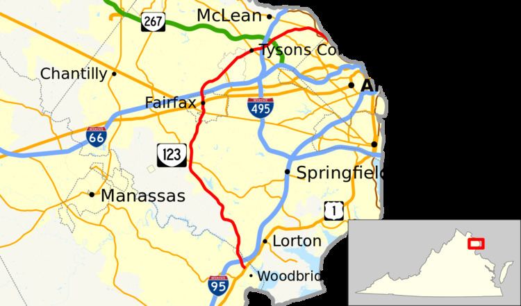
State Route 123 (SR 123) is a primary state highway in the U.S. state of Virginia. The state highway runs 29.27 miles (47.11 km) from U.S. Route 1 (US 1) in Woodbridge north to the Chain Bridge across the Potomac River into Washington from Arlington. It goes by three local names. From its southern terminus to the Occoquan River Bridge, it is known as Gordon Boulevard. From the Occoquan River Bridge to the city of Fairfax it is known as Ox Road. North from Fairfax, it is known as Chain Bridge Road. SR 123 is a partial circumferential highway in Northern Virginia that connects Woodbridge in eastern Prince William County with the independent city of Fairfax and the Fairfax County communities of Vienna, Tysons Corner, and McLean, the last the home of the National Counterterrorism Center and the Central Intelligence Agency. The state highway also connects all of the major highways that radiate from Washington, including Interstate 95, I-66, US 29, US 50, SR 267, and the George Washington Memorial Parkway. Furthermore, SR 123 crosses another pair of circumferential highways, I-495 and the Fairfax County Parkway, and SR 7, a major northwest–southeast highway through Northern Virginia. The state highway is a part of the National Highway System for its entire length.
Contents
Map of VA-123, Virginia, USA
Route description
SR 123 begins at an intersection with US 1 (Jefferson Davis Highway) between the Woodbridge Amtrak and Virginia Railway Express station and US 1's bridge over the Occoquan River in Woodbridge. The state highway heads north as Gordon Boulevard, a four- to six-lane divided highway. SR 123 meets I-95 at a partial cloverleaf interchange that contains a reversible ramp to and from the Interstate's HOV lanes in the direction of Washington. There is no access from southbound I-95 to southbound SR 123; that movement is provided indirectly via I-95's interchange with US 1 across the river in Fairfax County. The state highway passes through the eastern edge of the town of Occoquan and crosses the Occoquan River on a six-lane bridge.
SR 123 continues into Fairfax County as Ox Road, which passes through the western part of Lorton. The state highway passes by the former Lorton Reformatory and reduces to four lanes north of SR 611 (Furnace Road). SR 123 passes northwest along the edge of the suburban communities of Laurel Hill, Crosspointe, and South Run. The state highway serves the park surrounding Burke Lake, then veers north through a partial cloverleaf interchange with SR 286 (Fairfax County Parkway) to the west of Burke Centre. SR 123 crosses over Norfolk Southern Railway's Washington District rail line, which also carries the Manassas Line of Virginia Railway Express, at Springfield.
North of its intersection with SR 620 (Braddock Road), SR 123 passes along the west side of the campus of George Mason University, which includes the Patriot Center. The university's athletic complex, including George Mason Stadium, lies to the west of the state highway south of its intersection with University Drive, which heads east onto the campus as SR 383. North of University Drive, SR 123 enters the city of Fairfax and its name changes to Chain Bridge Road. The highway becomes undivided north of Judicial Drive; the state highway passes the Barbour House, the Historic Fairfax County Courthouse, and the Fairfax County offices and judicial center. North of SR 236 (Main Street), SR 123 reduces to two lanes and passes through an S-curve, then heads through a residential area before expanding to a four-lane divided highway at its intersection with US 29 and US 50 (Fairfax Boulevard).
SR 123 leaves the city of Fairfax at its partial cloverleaf interchange with I-66; the interchange includes a flyover ramp from westbound I-66 to southbound SR 123. The state highway curves northeast through Oakton, then enters the town of Vienna and becomes four-lane undivided Maple Avenue just south of its intersection with SR 243 (Nutley Street). SR 123 intersects the Washington and Old Dominion Trail adjacent to the Vienna Town Green. The state highway becomes a divided highway named Chain Bridge Road again on leaving the town limits and entering Tysons Corner, at the southwest edge of which SR 123 has a partial cloverleaf interchange with SR 7 (Leesburg Pike). SR 123 expands to six lanes and begins to parallel Washington Metro's Silver Line and intersects SR 684 (International Drive) before passing between a pair of shopping malls: Tysons Galleria to the north and Tysons Corner Center to the south.
At the eastern edge of Tysons Corner, SR 123 passes under Westpark Drive has a cloverleaf interchange with I-495 (Capital Beltway). The state highway, now named Dolley Madison Boulevard, follows the Silver Line northeast through office parks to a partial cloverleaf interchange with SR 267 (Dulles Toll Road), which leads west to the Dulles Access Road (unsigned SR 90004) and Washington Dulles International Airport and east to I-66. There is no access from northbound SR 123 to westbound SR 267; that movement requires using I-495. North of the interchange, in the hamlet of Lewinsville, the state highway reduces to four lanes and intersects SR 694 (Lewinsville Road), which provides access to the National Counterterrorism Center. SR 123 passes through McLean, the center of which is accessed via SR 309 (Old Dominion Drive).
East of the center of McLean, SR 123 passes by the preserved Salona estate and close to Hickory Hill—a historic house on Chain Bridge Road that was home to Robert F. Kennedy—in Langley, where the state highway meets the eastern end of SR 193 (Old Georgetown Pike). That state highway provides access to the Claude Moore Colonial Farm on the campus of the George Bush Center for Intelligence, the headquarters of the Central Intelligence Agency. The agency's southern main entrance is on SR 123. East of its partial cloverleaf interchange with the George Washington Memorial Parkway, the state highway's name becomes Chain Bridge Road and reduces to two lanes as it descends into the valley of the Potomac River. SR 123 passes by the Marden House before entering the northwestern corner of Arlington County and meeting the northern end of SR 120 (Glebe Road). There, SR 123 turns north and crosses the Potomac River into Washington on the three-lane Chain Bridge, which leads to the Clara Barton Parkway into Maryland and Canal Road, which follows the river east to Georgetown.
History
SR 123, along with SR 120, was SR 25 until the 1933 renumbering and SR 9 from then until the 1940 renumbering.
Fairfax County is considering upgrading the intersection between SR 123 and SR 620 to a full interchange. The designs being considered are diamond, modified diamond, single-point urban interchange (SPUI), and tight SPUI.
VDOT has drafted plans to create an interchange between SR 123 and US 1 in Woodbridge. However, due to budget cutbacks, the project has been put on hold.