
 | ||
An unmanned aerial vehicle (UAV), commonly known as a drone, is an aircraft without a human pilot aboard. UAVs are a component of an unmanned aircraft system (UAS); which include a UAV, a ground-based controller, and a system of communications between the two. The flight of UAVs may operate with various degrees of autonomy: either under remote control by a human operator, or fully or intermittently autonomously, by onboard computers.
Contents
- Terminology
- History
- Classification
- UAV components
- Body
- Power supply and platform
- Computing
- Sensors
- Actuators
- Software
- Loop principles
- Flight controls
- Communications
- Autonomy
- Basic principles
- Autonomy features
- Functions
- Reactive autonomy
- Simultaneous localization and mapping
- Swarming
- Cognitive radio
- Learning capabilities
- Market trends
- Animal imitation Ethology
- Endurance
- Reliability
- Aerospace
- Military
- Reconnaissance
- Attack
- Targets for military training
- Demining
- Civil
- Hobby and recreational use
- Commercial aerial surveillance
- Professional aerial surveying
- Commercial and motion picture filmmaking
- Journalism
- Law enforcement
- Search and rescue
- Scientific research
- Conservation
- Surveying
- Agriculture
- Passenger transport
- Existing UAVs
- Air traffic
- Malicious use
- Security vulnerabilities
- Wildfires
- Regulation
- Republic of Ireland
- Netherlands
- Canada
- South Africa
- Italy
- Recreational use
- Commercial use
- Government use
- Popular culture
- UAE Drones for Good Award
- References
Compared to manned aircraft, UAVs are often preferred for missions too "dull, dirty or dangerous" for humans. They originated mostly in military applications, although their use is expanding in commercial, scientific, recreational, agricultural, and other applications, such as policing and surveillance, product deliveries, aerial photography, agriculture and drone racing. Civilian drones now vastly outnumber military drones, with estimates of over a million sold by 2015.
Terminology
Multiple terms are used for unmanned aerial vehicles, which generally refer to the same concept.
The term drone, more widely used by the public, was coined in reference to the resemblance of navigation and loud-and-regular motor sounds of old military unmanned aircraft to the male bee. The term has encountered strong opposition from aviation professionals and government regulators.
The term unmanned aircraft system (UAS) was adopted by the United States Department of Defense (DoD) and the United States Federal Aviation Administration in 2005 according to their Unmanned Aircraft System Roadmap 2005–2030. The International Civil Aviation Organization (ICAO) and the British Civil Aviation Authority adopted this term, also used in the European Union's Single-European-Sky (SES) Air-Traffic-Management (ATM) Research (SESAR Joint Undertaking) roadmap for 2020. This term emphasizes the importance of elements other than the aircraft. It includes elements such as ground control stations, data links and other support equipment. A similar term is an unmanned-aircraft vehicle system (UAVS) remotely piloted aerial vehicle (RPAV), remotely piloted aircraft system (RPAS). Many similar terms are in use.
A UAV is defined as a "powered, aerial vehicle that does not carry a human operator, uses aerodynamic forces to provide vehicle lift, can fly autonomously or be piloted remotely, can be expendable or recoverable, and can carry a lethal or nonlethal payload". Therefore, missiles are not considered UAVs because the vehicle itself is a weapon that is not reused, though it is also unmanned and in some cases remotely guided.
The relation of UAVs to remote controlled model aircraft is unclear. UAVs may or may not include model aircraft. Some jurisdictions base their definition on size or weight, however, the US Federal Aviation Administration defines any unmanned flying craft as a UAV regardless of size. A radio-controlled aircraft becomes a drone with the addition of an autopilot artificial intelligence (AI), and ceases to be a drone when an AI is removed.
History
In 1849 Austria sent unmanned, bomb-filled balloons to attack Venice. UAV innovations started in the early 1900s and originally focused on providing practice targets for training military personnel.
UAV development continued during World War I, when the Dayton-Wright Airplane Company invented a pilotless aerial torpedo that would explode at a preset time.
The earliest attempt at a powered UAV was A. M. Low's "Aerial Target" in 1916. Nikola Tesla described a fleet of unmanned aerial combat vehicles in 1915. Advances followed during and after World War I, including the Hewitt-Sperry Automatic Airplane. The first scaled remote piloted vehicle was developed by film star and model-airplane enthusiast Reginald Denny in 1935. More emerged during World War II – used both to train antiaircraft gunners and to fly attack missions. Nazi Germany produced and used various UAV aircraft during the war. Jet engines entered service after World War II in vehicles such as the Australian GAF Jindivik, and Teledyne Ryan Firebee I of 1951, while companies like Beechcraft offered their Model 1001 for the U.S. Navy in 1955. Nevertheless, they were little more than remote-controlled airplanes until the Vietnam War.
In 1959, the U.S. Air Force, concerned about losing pilots over hostile territory, began planning for the use of unmanned aircraft. Planning intensified after the Soviet Union shot down a U-2 in 1960. Within days, a highly classified UAV program started under the code name of "Red Wagon". The August 1964 clash in the Tonkin Gulf between naval units of the U.S. and North Vietnamese Navy initiated America's highly classified UAVs (Ryan Model 147, Ryan AQM-91 Firefly, Lockheed D-21) into their first combat missions of the Vietnam War. When the Chinese government showed photographs of downed U.S. UAVs via Wide World Photos, the official U.S. response was "no comment".
The War of Attrition (1967–1970) featured the introduction of UAVs with reconnaissance cameras into combat in the Middle East.
In the 1973 Yom Kippur War Israel used drones as decoys to spur opposing forces into wasting expensive anti-aircraft missiles.
In 1973 the U.S. military officially confirmed that they had been using UAVs in Southeast Asia (Vietnam). Over 5,000 U.S. airmen had been killed and over 1,000 more were missing or captured. The USAF 100th Strategic Reconnaissance Wing flew about 3,435 UAV missions during the war at a cost of about 554 UAVs lost to all causes. In the words of USAF General George S. Brown, Commander, Air Force Systems Command, in 1972, "The only reason we need (UAVs) is that we don't want to needlessly expend the man in the cockpit." Later that year, General John C. Meyer, Commander in Chief, Strategic Air Command, stated, "we let the drone do the high-risk flying ... the loss rate is high, but we are willing to risk more of them ... they save lives!"
During the 1973 Yom Kippur War, Soviet-supplied surface-to-air missile batteries in Egypt and Syria caused heavy damage to Israeli fighter jets. As a result, Israel developed the first UAV with real-time surveillance. The images and radar decoys provided by these UAVs helped Israel to completely neutralize the Syrian air defenses at the start of the 1982 Lebanon War, resulting in no pilots downed. The first time UAVs were used as proof-of-concept of super-agility post-stall controlled flight in combat-flight simulations involved tailless, stealth technology-based, three-dimensional thrust vectoring flight control, jet-steering UAVs in Israel in 1987.
With the maturing and miniaturization of applicable technologies in the 1980s and 1990s, interest in UAVs grew within the higher echelons of the U.S. military. In the 1990s, the U.S. DoD gave a contract to AAI Corporation along with Israeli company Malat. The U.S. Navy bought the AAI Pioneer UAV that AAI and Malat developed jointly. Many of these UAVs saw service in the 1991 Gulf War. UAVs demonstrated the possibility of cheaper, more capable fighting machines, deployable without risk to aircrews. Initial generations primarily involved surveillance aircraft, but some carried armaments, such as the General Atomics MQ-1 Predator, that launched AGM-114 Hellfire air-to-ground missiles.
CAPECON was a European Union project to develop UAVs, running from 1 May 2002 to 31 December 2005.
As of 2012, the USAF employed 7,494 UAVs – almost one in three USAF aircraft. The Central Intelligence Agency also operated UAVs.
In 2013 at least 50 countries used UAVs. China, Iran, Israel and others designed and built their own varieties.
Classification
UAVs typically fall into one of six functional categories (although multi-role airframe platforms are becoming more prevalent):
The U.S. Military UAV tier system is used by military planners to designate the various individual aircraft elements in an overall usage plan.
Vehicles can be categorised in terms of range/altitude. The following has been advanced as relevant at industry events such as ParcAberporth Unmanned Systems forum:
Other categories include:
Classifications according to aircraft weight are quite simpler:
UAV components
Manned and unmanned aircraft of the same type generally have recognizably similar physical components. The main exceptions are the cockpit and environmental control system or life support systems. Some UAVs carry payloads (such as a camera) that weigh considerably less than an adult human, and as a result can be considerably smaller. Though they carry heavy payloads, weaponized military drones are lighter than their manned counterparts with comparable armaments.
Small civilian UAVs have no life-critical systems, and can thus be built out of lighter but less sturdy materials and shapes, and can use less robustly tested electronic control systems. For small UAVs, the quadcopter design has become popular, though this layout is rarely used for manned aircraft. Miniaturization means that less-powerful propulsion technologies can be used that are not feasible for manned aircraft, such as small electric motors and batteries.
Control systems for UAVs are often different than manned craft. For remote human control, a camera and video link almost always replace the cockpit windows; radio-transmitted digital commands replace physical cockpit controls. Autopilot software is used on both manned and unmanned aircraft, with varying feature sets.
Body
The primary difference for planes is the absence of the cockpit area and its windows. Tailless Quadcopters are a common form factor for rotary wing UAVs while tailed mono- and bi-copters are common for manned platforms.
Power supply and platform
Small UAVs mostly use lithium-polymer batteries (Li-Po), while larger vehicles rely on conventional airplane engines.
Battery elimination circuitry (BEC) is used to centralize power distribution and often harbors a microcontroller unit (MCU). Costlier switching BECs diminish heating on the platform.
Computing
UAV computing capability followed the advances of computing technology, beginning with analog controls and evolving into microcontrollers, then system-on-a-chip (SOC) and single-board computers (SBC).
System hardware for small UAVs is often called the Flight Controller (FC), Flight Controller Board (FCB) or Autopilot.
Sensors
Position and movement sensors give information about the aircraft state. Exteroceptive sensors deal with external information like distance measurements, while exproprioceptive ones correlate internal and external states.
Non-cooperative sensors are able to detect targets autonomously so they are used for separation assurance and collision avoidance.
Degrees of freedom (DOF) refer to both the amount and quality of sensors on-board: 6 DOF implies 3-axis gyroscopes and accelerometers (a typical inertial measurement unit – IMU), 9 DOF refers to an IMU plus a compass, 10 DOF adds a barometer and 11 DOF usually adds a GPS receiver.
Actuators
UAV actuators include digital electronic speed controllers (which control the RPM of the motors) linked to motors/engines and propellers, servomotors (for planes and helicopters mostly), weapons, payload actuators, LEDs and speakers.
Software
UAV software called the flight stack or autopilot. UAVs are real-time systems that require rapid response to changing sensor data. Examples include Raspberry Pis, Beagleboards, etc. shielded with NavIO, PXFMini, etc. or designed from scratch such as Nuttx, preemptive-RT Linux, Xenomai, Orocos-Robot Operating System or DDS-ROS 2.0.
List of civil-use open-source stacks include:
Loop principles
UAVs employ open-loop, closed-loop or hybrid control architectures.
Flight controls
Flight control is one of the lower-layer system and is similar to manned aviation: plane flight dynamics, control and automation, helicopter flight dynamics and controls and multirotor flight dynamics were researched long before the rise of UAVs.
Automatic flight involves multiple levels of priority.
UAVs can be programmed to perform aggressive manœuvres or landing/perching on inclined surfaces, and then to climb toward better communication spots. Some UAVs can control flight with varying flight modelisation, such as VTOL designs.
UAVs can also implement perching on a flat vertical surface.
Communications
Most UAVs use a radio frequency front-end that connects the antenna to the analog-to-digital converter and a flight computer that controls avionics (and that may be capable of autonomous or semi-autonomous operation).
Radio allows remote control and exchange of video and other data. Early UAVs had only uplink. Downlinks (e.g., realtime video) came later.
In military systems and high-end domestic applications, downlink may convey payload management status. In civilian applications, most transmissions are commands from operator to vehicle. Downstream is mainly video. Telemetry is another kind of downstream link, transmitting status about the aircraft systems to the remote operator. UAVs use also satellite "uplink" to access satellite navigation systems.
The radio signal from the operator side can be issued from either:
Autonomy
ICAO classifies unmanned aircraft as either remotely piloted aircraft or fully autonomous. Actual UAVs may offer intermediate degrees of autonomy. E.g., a vehicle that is remotely piloted in most contexts may have an autonomous return-to-base operation.
Basic autonomy comes from proprioceptive sensors. Advanced autonomy calls for situational awareness, knowledge about the environment surrounding the aircraft from exterioceptive sensors: sensor fusion integrates information from multiple sensors.
Basic principles
One way to achieve autonomous control employs multiple control-loop layers, as in hierarchical control systems. As of 2016 the low-layer loops (i.e. for flight control) tick as fast as 32,000 times per second, while higher-level loops may cycle once per second. The principle is to decompose the aircraft's behavior into manageable "chunks", or states, with known transitions. Hierarchical control system types range from simple scripts to finite state machines, behavior trees and hierarchical task planners. The most common control mechanism used in these layers is the PID controller which can be used to achieve hover for a quadcopter by using data from the IMU to calculate precise inputs for the electronic speed controllers and motors.
Examples of mid-layer algorithms:
Evolved UAV hierarchical task planners use methods like state tree searches or genetic algorithms.
Autonomy features
UAV manufacturers often build in specific autonomous operations, such as:
Functions
Full autonomy is available for specific tasks, such as airborne refueling or ground-based battery switching; but higher-level tasks call for greater computing, sensing and actuating capabilities. One approach to quantifying autonomous capabilities is based on OODA terminology, as suggested by a 2002 US Air Force Research Laboratory, and used in the table below:
Medium levels of autonomy, such as reactive autonomy and high levels using cognitive autonomy, have already been achieved to some extent and are very active research fields.
Reactive autonomy
Reactive autonomy, such as collective flight, real-time collision avoidance, wall following and corridor centring, relies on telecommunication and situational awareness provided by range sensors: optic flow, lidars (light radars), radars, sonars.
Most range sensors analyze electromagnetic radiation, reflected off the environment and coming to the sensor. The cameras (for visual flow) act as simple receivers. Lidars, radars and sonars (with sound mechanical waves) emit and receive waves, measuring the round-trip transit time. UAV cameras do not require emitting power, reducing total consumption.
Radars and sonars are mostly used for military applications.
Reactive autonomy has in some forms already reached consumer markets: it may be widely available in less than a decade.
Simultaneous localization and mapping
SLAM combines odometry and external data to represent the world and the position of the UAV in it in three dimensions. High-altitude outdoor navigation does not require large vertical fields-of-view and can rely on GPS coordinates (which makes it simple mapping rather than SLAM).
Two related research fields are photogrammetry and LIDAR, especially in low-altitude and indoor 3D environments.
Swarming
Robot swarming refers to networks of agents able to dynamically reconfigure as elements leave or enter the network. They provide greater flexibility than multi-agent cooperation. Swarming may open the path to data fusion. Some bio-inspired flight swarms use steering behaviors and flocking.
Future military potential
In the military sector, American Predators and Reapers are made for counterterrorism operations and in war zones in which the enemy lacks sufficient firepower to shoot them down. They are not designed to withstand antiaircraft defenses or air-to-air combat. In September 2013, the chief of the US Air Combat Command stated that current UAVs were "useless in a contested environment" unless manned aircraft were there to protect them.[167] A 2012 Congressional Research Service (CRS) report speculated that in the future, UAVs may be able to perform tasks beyond intelligence, surveillance, reconnaissance and strikes; the CRS report listed air-to-air combat ("a more difficult future task") as possible future undertakings.[168] The Department of Defense's Unmanned Systems Integrated Roadmap FY2013-2038 foresees a more important place for UAVs in combat.[169] Issues include extended capabilities, human-UAV interaction, managing increased information flux, increased autonomy and developing UAV-specific munitions.[169] DARPA's project of systems of systems, or General Atomics work may augur future warfare scenarios, the latter disclosing Avenger swarms equipped with High Energy Liquid Laser Area Defense System (HELLADS).
Cognitive radio
Cognitive radio technology may have UAV applications.
Learning capabilities
UAVs may exploit distributed neural networks.
Market trends
The UAV global military market is dominated by pioneers United States and Israel. The US held a 60% military-market share in 2006. It operated over 9,000 UAVs in 2014. From 1985 to 2014, exported drones came predominantly from Israel (60.7%) and the United States (23.9%); top importers were The United Kingdom (33.9%) and India (13.2%). Northrop Grumman and General Atomics are the dominant manufacturers on the strength of the Global Hawk and Predator/Mariner systems.
The leading civil UAV companies are currently (Chinese) DJI with $500m global sales, (French) Parrot with $110m and (US) 3DRobotics with $21.6m in 2014. As of February 2016, about 325,000 civilian drones were registered with the U.S. FAA, though it is estimated more than a million have been sold in the United States alone.
UAV companies are also emerging in developing nations such as India for civilian use, although it is at a very nascent stage, a few early stage startups have received support and funding.
Some universities offer research and training programs or degrees. Private entities also provide online and in-person training programs for both recreational and commercial UAV use.
Animal imitation – Ethology
Flapping-wing ornithopters, imitating birds or insects, are a research field in microUAVs. Their inherent stealth recommends them for spy missions.
The Nano Hummingbird is commercially available, while sub-1g microUAVs inspired by flies, albeit using a power tether, can "land" on vertical surfaces.
Other projects include unmanned "beetles" and other insects.
Research is exploring miniature optic-flow sensors, called ocellis, mimicking the compound insect eyes formed from multiple facets, which can transmit data to neuromorphic chips able to treat optic flow as well as light intensity discrepancies.
Endurance
UAV endurance is not constrained by the physiological capabilities of a human pilot.
Because of their small size, low weight, low vibration and high power to weight ratio, Wankel rotary engines are used in many large UAVs. Their engine rotors cannot seize; the engine is not susceptible to shock-cooling during descent and it does not require an enriched fuel mixture for cooling at high power. These attributes reduce fuel usage, increasing range or payload.
Hydrogen fuel cells, using hydrogen power, may be able to extend the endurance of small UAVs, up to several hours.
Micro air vehicles endurance is so far best achieved with flapping-wing UAVs, followed by planes and multirotors standing last, due to lower Reynolds number.
Solar-electric UAVs, a concept originally championed by the AstroFlight Sunrise in 1974, have achieved flight times of several weeks.
Solar-powered atmospheric satellites ("atmosats") designed for operating at altitudes exceeding 20 km (12 miles, or 60,000 feet) for as long as five years could potentially perform duties more economically and with more versatility than low earth orbit satellites. Likely applications include weather monitoring, disaster recovery, earth imaging and communications.
Electric UAVs powered by microwave power transmission or laser power beaming are other potential endurance solutions.
Another application for a high endurance UAV would be to "stare" at a battlefield for a long interval (ARGUS-IS, Gorgon Stare, Integrated Sensor Is Structure) to record events that could then be played backwards to track battlefield activities.
Reliability
Reliability improvements target all aspects of UAV systems, using resilience engineering and fault tolerance techniques.
Individual reliability covers robustness of flight controllers, to ensure safety without excessive redundancy to minimize cost and weight. Besides, dynamic assessment of flight envelope allows damage-resilient UAVs, using non-linear analysis with ad-hoc designed loops or neural networks. UAV software liability is bending toward the design and certifications of manned avionics software.
Swarm resilience involves maintaining operational capabilities and reconfiguring tasks given unita failures.
Aerospace
Airlines and maintenance, repair, and operations contractors use UAVs for aircraft maintenance. In June 2015 EasyJet began testing UAVs in the maintenance of their Airbus A320s and in July 2016 at the Farnborough Airshow, Airbus (manufacturer of the A320), demonstrated the use of UAVs for the visual inspection of an aircraft. However, some aircraft maintenance professionals remain wary of the technology and its ability to properly catch potential dangers.
A helicopter drone has been proposed to accompany a future NASA Mars rover mission. Investigators believe a solar-powered craft would be able to fly for a few minutes at a time despite the thin atmosphere of the planet, and help the rover scout out interesting destinations.
Military
As of January 2014, the U.S. military operated 7,362 RQ-11B Ravens; 145 AeroVironment RQ-12A Wasps; 1,137 AeroVironment RQ-20A Pumas; 306 RQ-16 T-Hawk small UAS; 246 Predators and MQ-1C Grey Eagles; 126 MQ-9 Reapers; 491 RQ-7 Shadows and 33 RQ-4 Global Hawk large systems.
The MQ-9 Reaper costs $12 million while an F-22 costs over $120 million.
Reconnaissance
The Tu-141 "Swift" reusable Soviet reconnaissance drone is intended for reconnaissance to a depth of several hundred kilometers from the front line at supersonic speeds. The Tu-123 "Hawk" is a supersonic long-range reconnaissance drone (UAV) intended for conducting photographic and signals intelligence to a distance of 3200 km; it was produced beginning in 1964. The La-17P (UAV) is a reconnaissance UAV produced since 1963. In 1945 the Soviet Union began producing "doodlebug". 43 Soviet/Russian UAV models are known.
In 2013, the U.S. Navy launched a UAV from a submerged submarine, the first step to "providing mission intelligence, surveillance and reconnaissance capabilities to the U.S. Navy's submarine force."
Attack
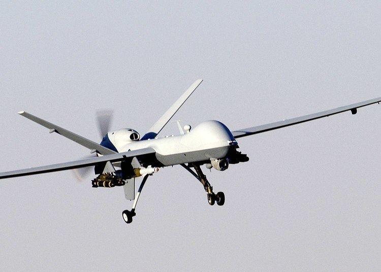
MQ-1 Predator UAVs armed with Hellfire missiles have been used by the U.S. as platforms for hitting ground targets. Armed Predators were first used in late 2001, mostly aimed at assassinating high-profile individuals (terrorist leaders, etc.) inside Afghanistan. UAVs avoid potential diplomatic embarrassment when a manned aircraft is shot down and the pilots captured.
Defense against UAVs
The US armed forces have no defense against low-level drone attack, but the Joint Integrated Air and Missile Defense Organization is working to repurpose existing systems. Two German companies are developing 40-kW lasers to damage UAVs. Other systems still include the OpenWorks Engineering Skywall and the Battelle DroneDefender.
Targets for military training
Since 1997, the US military has used more than 80 F-4 Phantoms converted into UAVs as aerial targets for combat training of human pilots. The F-4s were supplemented in September 2013 with F-16s as more realistically maneuverable targets.
Demining
Since January 2016 British scientists are developing drones with advanced imaging technology to more cheaply and effectively map and speed up the clearing of minefields. The Find A Better Way charity, working since 2011 to advance technologies that will enable safer and more efficient clearance of landmines, teamed up with scientists at the University of Bristol to develop drones fit with hyperspectral imaging technology that can quickly identify landmines buried in the ground. John Fardoulis, project researcher from Bristol University states that "the maps [their] drones will generate should help deminers focus on the places where mines are most likely to be found". Their intended drones will be able to perform flyovers and gather images at various wavelengths which, according to Dr John Day from the University of Bristol, could indicate explosive chemicals seeping from landmines into the surrounding foliage as "chemicals in landmines leak out and are often absorbed by plants, causing abnormalities" which can be detected as "living plants have a very distinctive reflection in the near infrared spectrum, just beyond human vision, which makes it possible to tell how healthy they are".
In the 2015 $1 million Drones for Good competition, Spanish company CATUAV was selected as a finalist for a drone fitted with optical sensors to scan war-affected regions of Bosnia and Herzegovina for landmines buried during the 1990s.
The Dutch Mine Kafon project, led by designer Massoud Hassani is working on a drone system that can quickly detect and clear land mines. The unmanned airborne de-mining system called Mine Kafon Drone uses a three step process to autonomously map, detect and detonate land mines. It flies above potentially dangerous areas, generating a 3D map, and uses a metal detector to pinpoint the location of mines. The drone can then place a detonator above the mines using its robotic gripping arm, before retreating to a safe distance. The firm claims its drone is safer, 20 times faster and up to 200 times cheaper than current technologies and might clear mines globally in 10 years. The project raised funds on the crowdfunding site Kickstarter with their goal set at €70,000 and receiving over €100,000 above it.
Civil
Civil uses include aerial crop surveys, aerial photography, search and rescue, inspection of power lines and pipelines, counting wildlife delivering medical supplies to otherwise inaccessible regions, and detection of illegal hunting, reconnaissance operations, cooperative environment monitoring, border patrol missions, convoy protection, forest fire detection and monitoring, surveillance, coordinating humanitarian aid, plume tracking, land surveying, fire and large-accident investigation, landslide measurement, illegal landfill detection, the construction industry and crowd monitoring.
US government agencies use UAVs such as the RQ-9 Reaper to patrol borders, scout property and locate fugitives. One of the first authorized for domestic use was the ShadowHawk in Montgomery County, Texas SWAT and emergency management offices.
Private citizens and media organizations use UAVs for surveillance, recreation, news-gathering, or personal land assessment. In February 2012, an animal rights group used a MikroKopter hexacopter to film hunters shooting pigeons in South Carolina. The hunters then shot the UAV down. In 2014, a drone was used to successfully locate a man with dementia, who was missing for 3 days.
Hobby and recreational use
Model aircraft (small UAS) have been flown by hobbyists since the earliest days of manned flight. In the United States, hobby and recreational use of such UAS is permitted (a) strictly for hobby or recreational use; (b) when operated in accordance with a community-based set of safety guidelines and nationwide community-based organizations; (c) when limited to not more than 55 pounds (with exceptions); (d)without interfering with and giving way to any manned aircraft; and (e) within 5 miles of an airport only after notifying air traffic control. The Academy of Model Aeronautics is a community based organization that maintains operational safety guidelines with a long proven history of effectiveness and safety.
Recreational uses of drones include:
Commercial aerial surveillance
Aerial surveillance of large areas is possible with low-cost UAS. Surveillance applications include livestock monitoring, wildfire mapping, pipeline security, home security, road patrol and antipiracy. UAVs in commercial aerial surveillance is expanding with the advent of automated object detection.
Professional aerial surveying
UAS technologies are used worldwide as aerial photogrammetry and LiDAR platforms.
Commercial and motion picture filmmaking
For commercial drone camerawork inside the United States, industry sources state that usage relies on the de facto consent – or benign neglect – of local law enforcement. Use of UAVs for filmmaking is generally easier on large private lots or in rural and exurban areas with fewer space constraints. In localities such as Los Angeles and New York, authorities have actively interceded to shut down drone filmmaking over safety or terrorism concerns.
In June 2014, the FAA acknowledged that it had received a petition from the Motion Picture Association of America seeking approval for the use of drones for aerial photography. Seven companies behind the petition argued that low-cost drones could be used for shots that would otherwise require a helicopter or a manned aircraft, saving money and reducing risk for pilot and crew. Drones are already used by media in other parts of the world.
UAVs have been used to film sporting events, such as the 2014 Winter Olympics, as they have greater freedom of movement than cable-mounted cameras.
Journalism
Journalists are interested in using drones for newsgathering. The College of Journalism and Mass Communications at University of Nebraska-Lincoln established the Drone Journalism Lab. University of Missouri created the Missouri Drone Journalism Program. The Professional Society of Drone Journalists was established in 2011. Drones have covered disasters such as typhoons. A coalition of 11 news organizations is working with the Mid-Atlantic Aviation Partnership at Virginia Tech on how reporters could use unmanned aircraft to gather news.
Law enforcement
Many police departments in India have procured drones for law and order and aerial surveillance.
UAVs have been used for domestic police work in Canada and the United States. A dozen US police forces had applied for UAV permits by March 2013. In 2013, the Seattle Police Department's plan to deploy UAVs was scrapped after protests. UAVs have been used by U.S. Customs and Border Protection since 2005. with plans to use armed drones. The FBI stated in 2013 that they use UAVs for "surveillance".
In 2014, it was reported that five English police forces had obtained or operated UAVs for observation. Merseyside police caught a car thief with a UAV in 2010, but the UAV was lost during a subsequent training exercise and the police stated the UAV would not be replaced due to operational limitations and the cost of staff training.
In August 2013, the Italian defence company Selex ES provided an unarmed surveillance drone to the Democratic Republic of Congo to monitor movements of armed groups in the region and to protect the civilian population more effectively.
Dutch train networks use tiny UAVs to look out for graffiti as an alternative to CCTV cameras.
Search and rescue
UAVs were used in search and rescue after hurricanes struck Louisiana and Texas in 2008. Predators, operating between 18,000 and 29,000 feet, performed search and rescue and damage assessment. Payloads were an optical sensor and a synthetic aperture radar. The latter can penetrate clouds, rain or fog and in daytime or nighttime conditions, all in real time. Photos taken before and after the storm are compared and a computer highlights damage areas. Micro UAVs, such as the Aeryon Scout, have been used to perform search and rescue activities on a smaller scale, such as the search for missing persons.
In 2014, a drone helped locate an 82-year-old man who had been missing for three days. The drone searched a 200-acre field and located the man in 20 minutes.
UAVs have been tested as airborne lifeguards, locating distressed swimmers using thermal cameras and dropping life preservers to swimmers.
Scientific research
UAVs are especially useful in accessing areas that are too dangerous for manned aircraft. The U.S. National Oceanic and Atmospheric Administration began using the Aerosonde unmanned aircraft system in 2006 as a hurricane hunter. The 35-pound system can fly into a hurricane and communicate near-real-time data directly to the National Hurricane Center. Beyond the standard barometric pressure and temperature data typically culled from manned hurricane hunters, the Aerosonde system provides measurements from closer to the water's surface than before. NASA later began using the Northrop Grumman RQ-4 Global Hawk for hurricane measurements.
Conservation
In 2011, Lian Pin Koh and Serge Wich conceived the idea of using UAVs for conservation-related applications, before coining the term 'Conservation Drone' in 2012.
By 2012 the International Anti-Poaching Foundation was using UAVs.
Anti-poaching
In June 2012, World Wide Fund for Nature (WWF) announced it would begin using UAVs in Nepal to aid conservation efforts following a successful trial of two aircraft in Chitwan National Park. The global wildlife organization planned to train ten personnel to use the UAVs, with operational use beginning in the fall. In August 2012, UAVs were used by members of the Sea Shepherd Conservation Society in Namibia to document the annual seal cull. In December 2013, the Falcon UAV was selected by the Namibian Government and WWF to help combat rhinoceros poaching. The drones will operate in Etosha National Park and will use implanted RFID tags.
In 2012, the WWFund supplied two FPV Raptor 1.6 UAVs to Nepal National Parks. These UAVs were used to monitor rhinos, tigers and elephants and deter poachers. The UAVs were equipped with time-lapse cameras and could fly for 18 miles at 650 feet.
In December 2012, Kruger National Park started using a Seeker II UAV against rhino poachers. The UAV was loaned to the South African National Parks authority by its manufacturer, Denel Dynamics of South Africa.
Anti-whaling activists used an Osprey UAV (made by Kansas-based Hangar 18) in 2012 to monitor Japanese whaling ships in the Antarctic.
In 2012, the Ulster Society for the Prevention of Cruelty to Animals used a quadcopter UAV to deter badger baiters in Northern Ireland. In March 2013, the British League Against Cruel Sports announced that they had carried out trial flights with UAVs and planned to use a fixed-wing OpenRanger and an "octocopter" to gather evidence to make private prosecutions against illegal hunting of foxes and other animals. The UAVs were supplied by ShadowView. A spokesman for Privacy International said that "licensing and permission for drones is only on the basis of health and safety, without considering whether privacy rights are violated." CAA rules prohibit flying a UAV within 50 m of a person or vehicle.
In Pennsylvania, Showing Animals Respect and Kindness used drones to monitor people shooting at pigeons for sport. One of their drones was shot down by hunters.
In March 2013, UAV conservation nonprofit ShadowView, founded by former members of Sea Shepherd Conservation Society, worked with antihunting charity the League Against Cruel Sports to expose illegal fox hunting in the UK. Hunt supporters have argued that using UAVs to film hunting is an invasion of privacy.
In 2014, Will Potter proposed using drones to monitor conditions on factory farms. The idea is to circumvent ag-gag prohibitions by keeping the drones on public property, but equipping them with cameras sensitive enough to monitor distant activities. Potter raised nearly $23,000 in 2 days for this project on Kickstarter.
Pollution monitoring
UAVs equipped with air quality monitors provide real time air analysis at various elevations.
Surveying
Oil, gas and mineral exploration and production
UAVs can be used to perform geophysical surveys, in particular geomagnetic surveys where measurements of the Earth's varying magnetic field strength are used to calculate the nature of the underlying magnetic rock structure. A knowledge of the underlying rock structure helps to predict the location of mineral deposits. Oil and gas production entails the monitoring of the integrity of oil and gas pipelines and related installations. For above-ground pipelines, this monitoring activity can be performed using digital cameras mounted on UAVs.
In 2012, Cavim, the state-run arms manufacturer of Venezuela, claimed to be producing its own UAV as part of a system to survey and monitor pipelines, dams and other rural infrastructure.
Disaster relief
Drones can help in disaster relief by providing intelligence across an affected area.
For example, two George Mason University students are aiming to design a device that uses soundwaves to extinguish fire. Their idea specifies using the technology with drones: Equip unmanned aerial vehicles with an extinguisher that works through soundwaves and send them into fires that are too dangerous for people to enter.
T-Hawk and Global Hawk drones were used to gather information about the damaged Fukushima Number 1 nuclear plant and disaster-stricken areas of the Tōhoku region after the March 2011 tsunami.
Archaeology
In Peru, archaeologists used drones to speed up survey work and protect sites from squatters, builders and miners. Small drones helped researchers produce three-dimensional models of Peruvian sites instead of the usual flat maps – and in days and weeks instead of months and years.
"You can go up three metres and photograph a room, 300 metres and photograph a site, or you can go up 3,000 metres and photograph the entire valley."
Drones have replaced expensive and clumsy small planes, kites and helium balloons. Drones costing as little as £650 have proven useful. In 2013, drones flew over Peruvian archaeological sites, including the colonial Andean town Machu Llacta 4,000 m (13,000 ft) above sea level. The drones had altitude problems in the Andes, leading to plans to make a drone blimp.
In Jordan, drones were used to discover evidence of looted archaeological sites.
In September 2014, drones were used for 3D mapping of the above-ground ruins of Aphrodisias and the Gallo-Roman remains in Switzerland.
On 6 February 2017 it was reported that scientists from the UK and Brazil discovered hundreds of ancient earthworks similar to those at Stonehenge in the Amazon rainforest with the use of drones.
Cargo transport
UAVs can transport medicines and medical specimens into and out of inaccessible regions. In 2013, in a research project of DHL, a small quantity of medicine was delivered via a UAV.
Initial attempts at commercial use of UAVs, such as the Tacocopter company for food delivery, were blocked by FAA regulation. A 2013 announcement that Amazon was planning deliveries using UAVs was met with skepticism.
In 2014, the prime minister of the United Arab Emirates announced that the UAE planned to launch a fleet of UAVs to deliver official documents and supply emergency services at accidents.
Google revealed in 2014 it had been testing UAVs for two years. The Google X program aims to produce drones that can deliver items.
16 July 2015, A NASA Langley fixed-wing Cirrus SR22 aircraft, flown remotely from the ground, operated by NASA's Langley Research Center in Hampton and a hexacopter drone delivered pharmaceuticals and other medical supplies to an outdoor free clinic at the Wise County Fairgrounds, Virginia. The aircraft picked up 10 pounds of pharmaceuticals and supplies from an airport in Tazewell County in southwest Virginia and delivered the medicine to the Lonesome Pine Airport in Wise County. The aircraft had a pilot on board for safety. The supplies went to a crew, which separated the supplies into 24 smaller packages to be delivered by small, unmanned drone to the free clinic, during multiple flights over two hours. A company pilot controlled the hexacopter, which lowered the pharmaceuticals to the ground by tether. Health care workers distributed the medications to appropriate patients.
The Uvionix Nksy aerial delivery service is planning to allow local shops to deliver goods from a drone. The company wants to deliver fast food, beer, coffee, soda, electronics, prescriptions and personal care products.
Agriculture
Japanese farmers have been using Yamaha's R-50 and RMAX unmanned helicopters to dust their crops since 1987. Some farming initiatives in the U.S. use UAVs for crop spraying, as they are often cheaper than a full-sized helicopter.
UAV are also now becoming an invaluable tool by farmers in other aspect of farming, such as monitoring livestock, crops and water levels. NDVI images, generated with a near-IR sensor, can provide detailed information on crop health, improving yield and reducing input cost. Sophisticated UAV have also been used to create 3D images of the landscape to plan for future expansions and upgrading.
Passenger transport
In January 2016, Ehang UAV announced drones capable of carrying passengers.
Light show
Drones equipped with LED's can be used to give a nighttime aerial display, for example Intels "Shooting star" drone system used by Disney and Super Bowl 2017 halftime show
Criminal and terrorist
Some drones have been observed dropping contraband onto U.S. prisons. The New York City Police Department is concerned about drone attacks with chemical weapons, firearms, or explosives; one drone nearly collided with an NYPD helicopter. Others have voiced concerns about assassinations and attacks on nuclear power stations.
Uses already seen include:
Existing UAVs
UAVs are being developed and deployed by many countries around the world. Due to their wide proliferation, no comprehensive list of UAV systems exists.
The export of UAVs or technology capable of carrying a 500 kg payload at least 300 km is restricted in many countries by the Missile Technology Control Regime.
As of 2016 China had exhibited many UAV designs, and its ability to operate them was beyond other countries.
Air traffic
UAVs can threaten airspace security in numerous ways, including unintentional collisions or other interference with other aircraft, deliberate attacks or by distracting pilots or flight controllers.
Malicious use
UAVs could be loaded with dangerous payloads, and crashed into vulnerable targets. Payloads could include explosives, chemical, radiologial or biological hazards.
Drones with generally non-lethal payloads could possibly be hacked and put to malicious purposes.
Security vulnerabilities
The interest in UAVs cyber security has been raised greatly after the Predator UAV video stream hijacking incident in 2009, where Islamic militants used cheap, off-the-self equipment to stream video feeds from a UAV. Another risk is the possibility of hijacking or jamming a drone in flight. In recent years several security researchers have made public vulnerabilities for commercial UAVs, in some cases even providing full source code or tools to reproduce their attacks. At a workshop on drones and privacy in October 2016, researchers from the Federal Trade Commission showed they were able to hack into three different consumer quadcopters and noted that drone manufacturers can make their drones more secure by the basic security measures of encrypting the Wi-Fi signal and adding password protection.
Wildfires
In the United States, flying close to a wildfire is punishable by a maximum $25,000 fine. Nonetheless, in 2014 and 2015, firefighting air support in California was hindered on several occasions, including at the Lake Fire and the North Fire. In response, California legislators introduced a bill that would allow firefighters to disable drones which invaded restricted airspace. The FAA later required registration of most drones.
The use of drones is also being investigated to help detect and fight wildfires, whether through observation or launching pyrotechnic devices to start backfires.
Regulation
Ethical concerns and UAV-related accidents have driven nations to regulate the use of UAVs.
Republic of Ireland
The Irish Aviation Authority (IAA) requires all UAVs over 1 kg must be registered with drones weighing 4 kg or more requiring a license to be issued by the IAA.
Netherlands
As of May 2016, the Dutch police is testing trained bald eagles to intercept offending drones.
Canada
In 2016 Transport Canada proposed the implementation of new regulations that would require all drones over 250 grams to be registered and insured and that operators would be required to be a minimum age and pass an exam in order to get a license. These regulations are expected to be introduced in 2017.
South Africa
In April 2014, the South African Civil Aviation Authority announced that it would clamp down on the illegal flying of UAVs in South African airspace. "Hobby drones" with a weight of less than 7 kg at altitudes up to 500m with restricted visual line-of-sight below the height of the highest obstacle within 300m of the drone are allowed. No license is required for such vehicles.
Italy
The ENAC (Ente Nazionale per l'Aviazione Civile), that is, the Italian_Civil_Aviation_Authority for technical regulation, certification, supervision and control in the field of civil aviation, issued on May 31st, 2016 a very detailed regulation for all UAV, determining which types of vehicles can be used, where, for which purposes, and who can control them. The regulation deals with the usage of UAV for either commercial and recreational use. Last version was published on December 22nd, 2016.
Recreational use
From 21 December 2015 all hobby type UAV's between 250 grams and 25 kilograms needed to be registered with FAA no later than 19 February 2016.
The new FAA UAV registration process includes requirements for:
Commercial use
On 21 June 2016 the Federal Aviation Administration announced regulations for commercial operation of small UAS craft (sUAS), those between 0.55 and 55 pounds (about 250 gm to 25 kg) including payload. The rules, which exclude hobbyists, require the presence at all operations of a licensed Remote Pilot in Command. Certification of this position, available to any citizen at least 16 years of age, is obtained solely by passing a written test and then submitting an application. For those holding a sport pilot license or higher, and with a current flight review, a rule-specific exam can be taken at no charge online at the faasafety.gov website. Other applicants must take a more comprehensive examination at an aeronautical testing center. All licensees are required to take a review course every two years. At this time no ratings for heavier UAS are available.
Commercial operation is restricted to daylight, line-of-sight, under 100 mph, under 400 feet, and Class G airspace only, and may not fly over people or be operated from a moving vehicle. Some organizations have obtained a waiver or Certificate of Authorization that allows them to exceed these rules. For example, CNN has obtained a waiver for drones modified for injury prevention to fly over people, and other waivers allow night flying with special lighting, or non-line-of-sight operations for agriculture or railroad track inspection.
Previous to this announcement, any commercial use required a full pilot's license and an FAA waiver, of which hundreds had been granted.
Government use
The use of UAVs for law-enforcement purposes is regulated at a state level.
Popular culture
UAE Drones for Good Award
In 2014, the United Arab Emirates announced an annual international competition and $1 million award, UAE Drones for Good, aiming to encourage useful and positive applications for UAV technology in applications such as in search and rescue, civil defence and conservation. The 2015 award was won by Swiss company Flyability, while the 2016 edition awarded Loon Copter's sea-hybrid UAV.