
Constructed 11 November 1926 | Length 801.5 km | |
 | ||
Existed: November 11, 1926 (1926-11-11) – October 6, 1989 (1989-10-06) Counties Yuma County, Arizona, Maricopa County, Arizona, Pinal County, Arizona, Pima County, Arizona, Cochise County, Arizona | ||
U.S. Route 80 (US 80) also known as the Ocean-to-Ocean Highway was a major transcontinental highway which existed in the U.S. state of Arizona from November 11, 1926 to October 6, 1989. At its peak, US 80 traveled from the California border in Yuma to the New Mexico state line near Lordsburg. Locals often used US 80 to reach the beaches around San Diego during the hot Arizona summers. US 80 was a particularly long highway, reaching almost 500 miles (800 km) long within the state of Arizona alone. With the advent of the Interstate Highway System, Interstate 10 and Interstate 8 both replaced US 80 within the state. US 80 was removed from Arizona in 1989; the remainder of it now being State Route 80.
Contents
History
The general path of the Gila Trail in Arizona was traversed by Native Americans for thousands of years. The first non-Native person to travel the Gila Trail was a Spanish owned African slave named Esteban, who had been brought to North America in 1527 as part of the colonization of Florida by Charles V of Spain. In 1538, Esteban accompanied a Franciscan Monk by the name of Marcos de Niza on a quest, which included travelling along the Gila Trail. Father Eusebio Kino utilized the Gila Trail to establish missions across present day southern Arizona and California. In 1821, southern Arizona had become part of Mexico. The first Americans on the trail were 19th Century fur trappers, who made use of the nearby Gila River's beaver population. During the Mexican-American War Lieutenant General Stephen W. Kearney of the United States Army sent his Army of the West over the Gila Trail, followed by companies of the Mormon Battalion the following year. Following the Mexican-American War, the Treaty of Guadalupe Hidalgo in 1848 and the Gadsden Purchase in 1853, the land surrounding the Gila Trail became part of the United States and was organized as New Mexico Territory in 1850. Arizona was established as a territory in 1863 and was granted statehood in 1912.
The Gila Trail was improved into Cooke's Wagon Road, named after Captain Philip St. George Cooke, leader of the Mormon Battalion. By 1909, Cooke's Wagon Road had become the East-West Territorial Road and North-South Territorial Road respectively. The former route travelled between Yuma and Phoenix while the latter travelled between Phoenix, Tucson and Douglas. Using funding from the Bureau of Indian Affairs, the Ocean-to-Ocean bridge was constructed between Winterhaven, California and Yuma in 1914. Between 1917 and 1919, the Dixie Overland Highway was established from Savannah, Georgia to San Diego, California, becoming the first Auto trail to be designated over what would later be U.S. Route 80. From Yuma to New Mexico, the Dixie Overland Highway followed the basic route of US 80 in Arizona very closely. This was joined by the Bankhead Highway in 1920 and the Old Spanish Trail highway in 1923. Between 1916 and 1924, these early routes were re-aligned between Dome and Buckeye to follow the Southern Pacific Railroad more closely. The re-alignment moved the routes off the northern edge of the Gila River, where the highway had been subject to numerous washouts. Paving within Arizona began in 1920.
In April 1925, the Joint Board on Interstate Highways, appointed by the then Secretary of Agriculture to simplify the transcontinental highways, proposed a new nationwide numbered highway system. The new highways were to follow a uniform standard of shields and numbering. This system was to become the U.S. Numbered Highway System. By October 1925, a proposed route under the numeric designation "80" was proposed along a similar path to the Dixie Overland Highway, Old Spanish Trail and Bankhead Highway. In November 1926, the American Association of State Highway Officials (AASHO) approved of the new system, which included US 80 between Savannah, Georgia and San Diego, California.
In 1927, a steel truss bridge was constructed over the Gila River next to the Gillespie Dam. Prior to the construction of the bridge, traffic utilized a concrete apron constructed at the foot of the dam to cross the river. At the time, it was the largest steel structure in the state of Arizona. The bridge was added to the National Register of Historic Places on May 5, 1981. In 1928, the section of US 80 through telegraph pass was constructed, being paved by 1931. That same year, the Mill Street Bridge in Tempe was constructed. Reconstruction and paving on the section through Mule Pass occurred in 1932. The Cienega Creek Bridge east of Tucson was completed in 1934 as was the Stone Avenue railroad underpass within Tucson in 1936. By 1939, the entire highway was paved within the state of Arizona, save for a small section between Florence and Oracle Junction. By 1945, that section was reconstructed and paved. Further reconstruction of the section through Telegraph Pass was completed in 1948. The Mule Pass Tunnel was constructed in 1952, becoming the longest tunnel in Arizona. Two straighter and faster alignments of US 80 were constructed in 1956, bypassing the Gillespie Dam area and Cienega Creek.
Following the creation of the Interstate Highway System in 1957, Interstate 10 and Interstate 8 were both slated to replace US 80. Construction on the first section of I-10 had been completed in 1953 as SR 84A and the first section completed to Interstate standards opened in 1955. The first sections of I-8 were completed in 1959. Construction on both Interstates progressed steadily throughout the 1960s and 1970s. Between 1964 and 1969, California retired its section of US 80 in favor of I-8, effectively moving the western end of US 80 to the California state line in Yuma.
In 1977, Arizona requested a truncation of US 80 to Benson. The AASHTO approved the request, decommissioning all of US 80 between Yuma and Benson as of October 28 of that year. Part of the section of US 80 between Gila Bend and Phoenix became an extension of SR 85. In 1989, both Arizona and New Mexico requested the elimination of US 80 in both states, removing US 80 entirely from Arizona on October 6. A former section of US 80 between Buckeye and Phoenix, signed as SR 85 at the time, was still used by Interstate traffic through Phoenix until I-10 completed construction through Phoenix in 1990. A few sections of old US 80 throughout Arizona pay homage to the retired highway in their names, such as Old U.S. Highway 80 between Gila Bend and Buckeye.
Route description
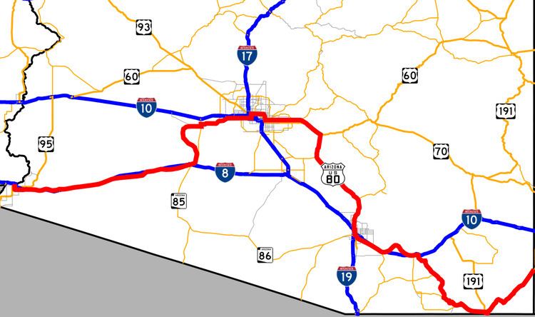
On its journey across Arizona, US 80 made two indirect "loops" to both Phoenix and Douglas. Both loops were likely bypassed often by travelers, using SR 84 and SR 86 respectively to decrease travel time between California and New Mexico. The odd shape created by the two "loops" gave US 80 an incredible length through the state of Arizona alone, coming close to 500 miles (800 km) in total. In 1934, US 80 was 500.5 miles (805.5 km) long. By 1951, the total length had reduced to about 498 miles (801 km), shrinking further to 488 miles (785 km) in 1956 with the bypass of Arlington.
US 80 entered Arizona from New Mexico on current New Mexico State Road 80 and Arizona State Route 80 near Rodeo. US 80 wound southwest into Douglas intersecting with US 666 (now US 191). From Douglas, US 80 ran northwest, then north through Lowell, Bisbee, Tombstone and St. David meeting up with SR 86 in Benson. The route between New Mexico and Benson has been subject to change. Prior to the construction of the Mule Pass Tunnel in 1952, US 80 used Main Street and North Old Divide Road through Bisbee. Through Tombstone, US 80 once used Allen Street (which is now a pedestrian mall). Many older gradual curves and alignments of US 80 are visible between Douglas and Benson, some of which are still driveable. Originally, US 80 entered Benson on what is now Catarina Street and Gila Street, before later being switched to the route currently followed by SR 80. US 80 met up with SR 86 (now I-10 Business) in downtown Benson where the two routes headed west towards Tucson. Much of US 80 to Tucson has since been overlaid by Interstate 10 with a few exceptions. Near Exit 302, an old gradual curve of US 80 constitutes as Titan Drive. Older US 80 followed Marsh Station Road between I-10 exits 289 and 281 until the early 1950s. US 80 followed the north Frontage road past Exit 281 before merging back into the routing of I-10.
In Tucson, US 80 and SR 86 left I-10's routing and headed west along Benson Highway, briefly merging back into I-10's routing to meet US 89 at 6th Avenue. SR 86 split off at this junction heading west to Ajo, while US 80 and US 89 headed north through Tucson on 6th Avenue, Stone Avenue, Drachman Street and Oracle Road, passing the junction with SR 84 at the Miracle Mile. US 80 and US 89 continued north along present day SR 77 and SR 79 through Florence. The older route in Florence took the SR 79 business route, Main Street and Ruggles Street through town. US 80/US 89 met up with US 60/70 at Florence Junction, where all four highways headed west towards Phoenix. Modern US 60 still travels this route. The original Florence Junction lies north of the current one. From this point, the earliest routings of US 60, US 80 and US 89 used El Camino Viejo, an old gravel road, before re-joining modern US 60 west of Florence. The latter alignment used modern US 60. At Apache Junction, Old US 60/US 70/US 80/US 89 continued heading northwest onto Old West Highway where present day US 60 turns west onto the Superstition Freeway, then turned west onto East Apache Trail at the intersection with SR 88.
The four highways continued heading west on Apache Trail/Main Street through Mesa into to Tempe, where the concurrent routes turned north onto Mill Street, crossed the Salt River then curved west onto Van Buren Street into Phoenix. At the intersection with Grand Avenue, US 60, US 70 and US 89 left US 80 heading northwest to Wickenburg. US 80 continued west on Van Buren, then turned south onto 17th Avenue, passing in front of the Arizona State Capitol then turned west onto Buckeye Road. US 80 headed west through Avondale, Goodyear and Buckeye using Buckeye Road, MC 85 and Baseline Road. US 80 turned south at the junction with SR 85.
The final route of US 80 took SR 85 south to Gila Bend, while the older route, which was bypassed in 1951, took an "S" shape further west following the Gila River, crossing it at one point over a 1927 bridge south of the Gillespie Dam. The older route is known today as "Old U.S. Highway 80" and is only accessible from SR 85 via Hazen Road and Wilson Road. US 80 met SR 84 again in Gila Bend, where it curved west through town on the Interstate 8 Business Loop, the followed what is now the I-8 south Frontage Road before being subsumed into I-8. The old route of US 80 breaks away from time to time and appears within the freeway median. Around Exit 78, US 80 curved briefly onto the North Frontage Road, passed in front of a Texaco station (now abandoned) then took the south Frontage Road through Dateland. West of Dateland, US 80 became the present day eastbound lanes of Interstate 8 before breaking off again at Exit 54 under the guise of Old Highway 80 through Mohawk Pass along with the hamlets of Owl and Tacna before passing through the town of Wellton. Between Mohawk Pass and Telegraph Pass, there are a few older incarnations of US 80 which deviate from the main route. Some of these older routings are no longer maintained.
West of Wellton, post 1928 US 80 followed present day I-8 through the Telegraph Pass (part of which can be seen around the point where the eastbound and westbound lanes of I-8 switch over) to the I-8 Business Loop, while the earlier route followed Avenue 20 E from Ligurta to a Gravel Road following the Union Pacific Railroad through the ghost town of Dome then southwest along present day US 95 and an abandoned road parallel to the railroad where it met up with the later route in Yuma. US 80 travelled through town along the I-8 Business Loop, turning north, crossing an intersection with US 95 to the Colorado River. The older route used the 1914 Ocean-to-Ocean Bridge, which was bypassed in 1956 to cross into California, while the later alignment continued straight ahead into California.
Major intersections
This list follows the 1951 alignment.