
Constructed 26 November 1926 | Length 265.4 km | |
 | ||
Existed: November 26, 1926 – present | ||
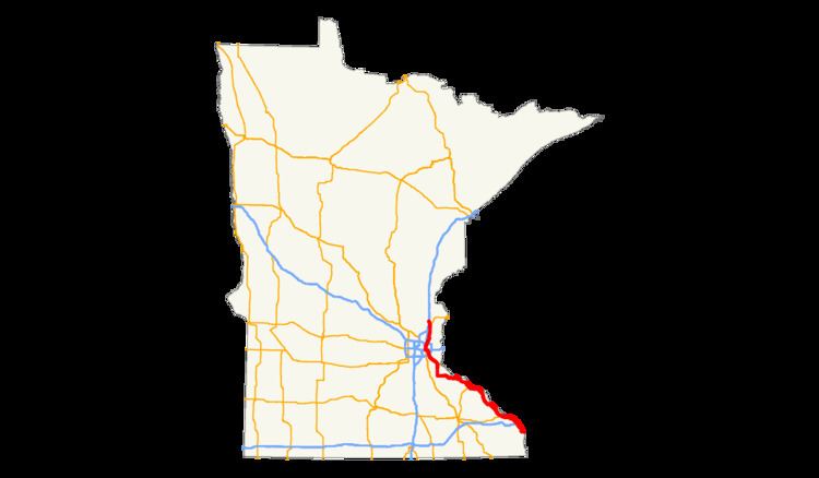
U.S. Highway 61 (U.S. 61) is a highway in southeast and east-central Minnesota, which runs from the River Bridge over the Mississippi River at La Crescent and continues north to its northern terminus at its junction with Interstate 35 at the city of Wyoming.
Contents
U.S. 61 in Minnesota is 165 miles (266 km) in length. The route connects the cities of La Crescent, Winona, Wabasha, Lake City, Red Wing, Hastings, Cottage Grove, Saint Paul, Forest Lake, and Wyoming.
Route description
U.S. Highway 61 enters the state of Minnesota at the city of La Crescent on the River Bridge over the Mississippi River between the cities of La Crosse and La Crescent. U.S. 61 is concurrent with U.S. 14 and State Highway 16 as it enters the state.
The four-lane divided highway continues north through La Crescent. U.S. 61 follows the Mississippi River through southeast Minnesota; through the cities of Winona, Wabasha, Lake City, and Red Wing. Highway 61 is a two-lane roadway between Wabasha and Red Wing.
U.S. 61 crosses the Mississippi River at Hastings over the Hastings High Bridge and joins U.S. 10 at Cottage Grove. U.S. 61 and U.S. 10 are concurrent as a freeway between Cottage Grove and the city of Saint Paul.
Within the city of Saint Paul, U.S. 61 follows Interstate 94 for a short distance, and then follows Mounds Boulevard, East 7th Street, and Arcade Street through the East Side of St. Paul.
U.S. 61 then proceeds north to Maplewood, where it becomes a four-lane highway named "Maplewood Drive" to White Bear Lake. Between Interstate 694 and the central business district of White Bear Lake, the road serves one of the Twin Cities region's major car dealership areas. After leaving White Bear Lake, U.S. 61 is a two-lane roadway again to Forest Lake and then to its northern terminus at the city of Wyoming.
Highway 61 closely parallels Interstate 35E and Interstate 35 from Saint Paul to Wyoming.
120 miles (190 km) of U.S. 61 from La Crescent to Cottage Grove in southeast Minnesota is officially designated the Disabled American Veterans Highway.
Legally, the Minnesota section of U.S. 61 is defined as unmarked legislative routes 3, 104, 102 and 1 in the Minnesota Statutes. U.S. 61 is not marked with these legislative numbers along the actual highway.
History
Highway 61 in Minnesota is an original U.S. Route, established on November 26, 1926. It originally extended north to the U.S.-Canada border at Grand Portage, but was cut back to its present terminus in 1991. The portion between Duluth and Grand Portage is now Minnesota State Highway 61. Segments of the old alignment that parallels MN-61 and I-35 have been designated County Road 61.
In 1929, the only unpaved portions were from Hastings to Wabasha and from Winona to the state line. It was completely paved by 1940.
The expressway sections south of Wabasha were built in the 1960s and the 1970s. The four lane divided highway section between Red Wing and State Highway 316 near Miesville was completed in 1997. The freeway section of U.S. 61 between Cottage Grove and I-494 at Newport was completed in 2007.