
Existed: 1985 – present Constructed 1985 | Length 69.2 km | |
 | ||
Counties | ||
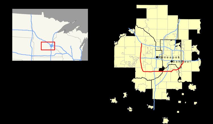
Interstate 494 (I-494) is a loop route making up part of a beltway of Interstate 94, circling through the southern and western portions of the Minneapolis – Saint Paul metropolitan area in Minnesota. The 43-mile (69 km) road is coupled with Interstate 694 (which circles the northern edge of the Twin Cities metro area) at each end, and composes more than half of the major beltway of the region. I-694 / I-494 also act as loop routes for Interstate 35E and Interstate 35W.
Contents
Map of I-494, Minnesota, USA
I-494 has a few intersections with other interstates:
The speed limit on I-494 is 60 miles per hour (100 km/h). Interstate highways outside of the loop in Minnesota may be signed as high as 70 mph (110 km/h). Most highways inside the loop are signed at speeds of 55 mph (90 km/h) or lower, though a few exceptions were added in September 2005, allowing speeds of up to 60 mph (97 km/h) in some places. Those roads had been signed at 60 mph (97 km/h) or higher up until the gasoline crisis of the 1970s.
Route description
Exit numbering of Interstate 494 is unusual in that it begins at the Minnesota River heading westbound (between Mendota Heights and Bloomington), and continues clockwise around the entire beltway. The last exit is #71 to Pilot Knob Road. The most significant landmark on the length of I-494 is Mall of America, just south of the intersection of I-494 and State Highway 77.
Legally, the route of Interstate 494 is defined as part of unmarked legislative route 393 in Minnesota Statutes § 161.12(5). [1] Interstate 494 is not marked with this legislative number along the actual highway.
History
Construction on Interstate 494 first began in the late 1950s, and it was finally completed in 1985. With the most recent upgrade completed in November 2016, Interstate 494 is now at least three lanes in each direction for its entire route.
Expansion of the Wakota Bridge between Newport and South St. Paul over the Mississippi River was completed in the summer of 2010. The bridge is named so because it connects Washington County and Dakota County. Near the end of this effort, Interstate 494 was widened from two to three lanes in each direction between Lake Road and I-94 in Woodbury.
A major reconstruction / widening project of I-494 was completed in fall 2006 between U.S. Highway 212 / State Highway 5 in Eden Prairie and Carlson Parkway at Minnetonka / Plymouth. Plans for up to six lanes in each direction for parts of I-494 in Bloomington are proposed but not yet funded.
494 Corridor Commission
The 494 Corridor Commission, also known as 494 Commuter Services, is a non-profit organization aimed at reducing traffic congestion along the southwest section of the Interstate 494 corridor. In 1988, the cities of Bloomington, Eden Prairie, Edina, Minnetonka, and Richfield joined together to address traffic congestion and work towards improving I-494. The organization's mission is to promote economic growth and regional prosperity through improved transportation options along the highway, such as carpooling and bus transit. The organization's board of directors consists of representatives from each of the five member cities, the Minnesota Department of Transportation, the Metropolitan Council, and the private business community.